Laas (Lasa)
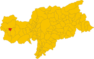
- Italian comune in South Tyrol
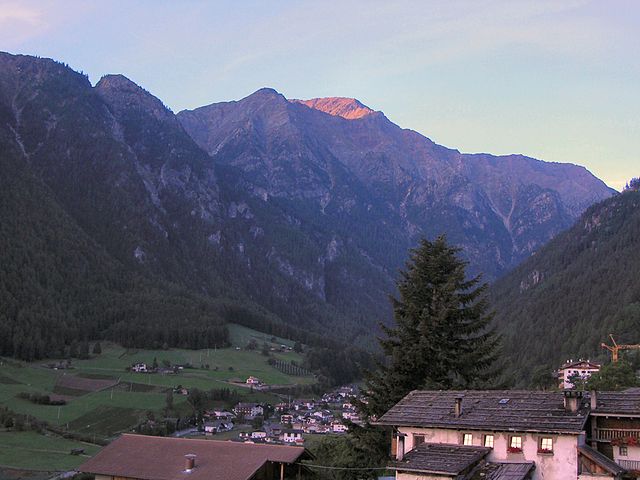
Laas, located in the stunning South Tyrol region of northern Italy, is a small village known for its beautiful landscapes and excellent hiking opportunities. Nestled in the heart of the Alps, Laas boasts a mix of gentle trails and more challenging routes, making it suitable for hikers of all levels.
Key Highlights of Hiking in Laas:
-
Scenic Trails: The trails around Laas offer stunning views of the surrounding mountains, valleys, and forests. Many paths lead through lush meadows dotted with wildflowers in the spring and summer.
-
Variety of Routes: Hikers can choose from various trails that range in difficulty. For example, there are easier walking paths suitable for families, as well as more challenging hikes that lead to high mountain passes and viewpoints.
-
Historical Significance: Some trails may pass historical sites, including old mines and chapels, giving a glimpse into the region's cultural heritage.
-
Wildlife Watching: The area is home to diverse wildlife, so keep an eye out for local fauna, including deer, marmots, and various bird species.
-
Well-Marked Paths: The hiking trails are generally well-marked, making navigation easier. It’s a good idea to have a local hiking map or app to guide you along the routes.
-
Local Cuisine: After a day of hiking, you can enjoy traditional Tyrolean cuisine in local restaurants. Look for dishes featuring local ingredients, including dumplings, speck, and apple strudel.
-
Accessibility: Laas is accessible from larger towns like Glurns or the city of Merano, which serve as good starting points for hiking excursions.
Popular Hiking Routes:
- Laaser Tal: A beautiful valley that offers multiple trails and scenic spots for rest and picnicking.
- Blücch Montalto/Monteleone: A hike that offers fantastic panoramic views of the Venosta Valley and surrounding peaks.
- St. John in the Mountain: A gentle trail that leads to an idyllic church with spectacular views.
Tips for Hiking in Laas:
- Best Time to Hike: Late spring to early autumn is ideal due to mild weather and beautiful scenery. Summer can be warm, while fall offers stunning foliage.
- Gear Up: Ensure you wear appropriate hiking boots and clothing, and carry enough water and snacks.
- Weather Check: Always check the local weather forecast before heading out, as conditions can change quickly in the mountains.
- Respect Nature: Stay on marked paths and follow local guidelines to protect the natural environment.
By exploring the trails of Laas, you will experience the unique beauty of South Tyrol while enjoying the fresh alpine air and breathtaking landscapes. Happy hiking!
- Country:

- Postal Code: 39023
- Local Dialing Code: 0473
- Licence Plate Code: BZ
- Coordinates: 46° 37' 4" N, 10° 41' 52" E


- GPS tracks (wikiloc): [Link]
- AboveSeaLevel: 868 м m
- Area: 110.23 sq km
- Population: 4028
- Web site: http://www.gemeinde.laas.bz.it
- Wikipedia en: wiki(en)
- Wikipedia: wiki(it)
- Wikidata storage: Wikidata: Q420306
- Wikipedia Commons Gallery: [Link]
- Wikipedia Commons Category: [Link]
- Freebase ID: [/m/0g9h8t]
- GeoNames ID: Alt: [6535905]
- VIAF ID: Alt: [144586737]
- OSM relation ID: [47258]
- GND ID: Alt: [4363729-2]
- Library of Congress authority ID: Alt: [no2002071455]
- MusicBrainz area ID: [ca48b0b9-67d5-43c1-9f36-2ef72fcf10eb]
- UN/LOCODE: [ITLAS]
- ISTAT ID: 021042
- Italian cadastre code: E457
Shares border with regions:


Mals
- Italian comune
Mals, located in the Vinschgau Valley in South Tyrol, Italy, is a fantastic spot for hiking enthusiasts. Surrounded by stunning landscapes, picturesque villages, and a rich cultural heritage, it offers a variety of trails suitable for different skill levels....
- Country:

- Postal Code: 39024
- Local Dialing Code: 0473
- Licence Plate Code: BZ
- Coordinates: 46° 41' 16" N, 10° 32' 48" E


- GPS tracks (wikiloc): [Link]
- AboveSeaLevel: 1051 м m
- Area: 247.43 sq km
- Population: 5225
- Web site: [Link]


Martell
- Italian comune in South Tyrol
Martell is a picturesque valley located in South Tyrol, Italy, known for its breathtaking landscapes, diverse flora and fauna, and excellent hiking trails. Here are some key points to consider if you're planning a hiking trip to Martell:...
- Country:

- Postal Code: 39020
- Local Dialing Code: 0473
- Licence Plate Code: BZ
- Coordinates: 46° 33' 17" N, 10° 46' 50" E


- GPS tracks (wikiloc): [Link]
- AboveSeaLevel: 1312 м m
- Area: 142.8 sq km
- Population: 853
- Web site: [Link]


Prad am Stilfser Joch
- Italian comune
 Hiking in Prad am Stilfser Joch
Prad am Stilfser Joch is a charming village located in the South Tyrol region of Italy, nestled at the entrance to the Stilfser Joch National Park. This area is renowned for its stunning natural landscapes, mountainous terrain, and excellent hiking opportunities. Here are some highlights and tips for hiking in this region:...
- Country:

- Postal Code: 39026
- Local Dialing Code: 0473
- Licence Plate Code: BZ
- Coordinates: 46° 37' 8" N, 10° 35' 29" E


- GPS tracks (wikiloc): [Link]
- AboveSeaLevel: 3375 м m
- Area: 51.49 sq km
- Population: 3474
- Web site: [Link]


Schluderns
- Italian comune
Schluderns, located in South Tyrol, Italy, is a charming village surrounded by stunning landscapes and offers a variety of hiking opportunities. The region is characterized by its mountainous terrain, lush forests, and picturesque valleys. Here are some key points to consider when planning a hike in and around Schluderns:...
- Country:

- Postal Code: 39020
- Local Dialing Code: 0473
- Licence Plate Code: BZ
- Coordinates: 46° 39' 55" N, 10° 35' 0" E


- GPS tracks (wikiloc): [Link]
- AboveSeaLevel: 921 м m
- Area: 20.72 sq km
- Population: 1820
- Web site: [Link]


Stilfs
- Italian comune
Stilfs, also known as Stilfs or Stelvio, is a charming village located in the South Tyrol region of northern Italy. It serves as a fantastic gateway for hiking enthusiasts looking to explore the beautiful and diverse landscapes of the nearby Stelvio National Park. Here are some highlights of hiking in and around Stilfs:...
- Country:

- Postal Code: 39020
- Local Dialing Code: 0473
- Licence Plate Code: BZ
- Coordinates: 46° 35' 52" N, 10° 32' 45" E


- GPS tracks (wikiloc): [Link]
- AboveSeaLevel: 1311 м m
- Area: 141.63 sq km
- Population: 1150
- Web site: [Link]


Schlanders
- Italian comune
Schlanders, located in the South Tyrol region of northern Italy, offers a wonderful hiking experience amid stunning alpine scenery. Surrounded by the impressive peaks of the Ortler Alps and near the beautiful Vinschgau Valley, this area is ideal for both novice and experienced hikers....
- Country:

- Postal Code: 39028
- Local Dialing Code: 0473
- Licence Plate Code: BZ
- Coordinates: 46° 37' 42" N, 10° 46' 5" E


- GPS tracks (wikiloc): [Link]
- AboveSeaLevel: 720 м m
- Area: 115.17 sq km
- Population: 6181
- Web site: [Link]
