Lamelouze (Lamelouze)

- commune in Gard, France
- Country:

- Postal Code: 30110
- Coordinates: 44° 11' 38" N, 3° 57' 50" E


- GPS tracks (wikiloc): [Link]
- Area: 8.83 sq km
- Population: 139
- Wikipedia en: wiki(en)
- Wikipedia: wiki(fr)
- Wikidata storage: Wikidata: Q859750
- Wikipedia Commons Category: [Link]
- Freebase ID: [/m/03c0s_z]
- GeoNames ID: Alt: [6431309]
- SIREN number: [213001373]
- BnF ID: [15254777q]
- PACTOLS thesaurus ID: [pcrtlDVuowYLVo]
- INSEE municipality code: 30137
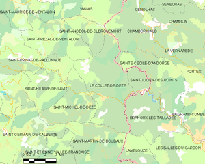
Shares border with regions:


Branoux-les-Taillades
- commune in Gard, France
- Country:
- Postal Code: 30110
- Coordinates: 44° 13' 13" N, 3° 59' 25" E
- GPS tracks (wikiloc): [Link]
- Area: 15.02 sq km
- Population: 1368


Les Salles-du-Gardon
- commune in Gard, France
- Country:
- Postal Code: 30110
- Coordinates: 44° 12' 25" N, 4° 2' 5" E
- GPS tracks (wikiloc): [Link]
- Area: 21.09 sq km
- Population: 2618
Soustelle
- commune in Gard, France
- Country:
- Postal Code: 30110
- Coordinates: 44° 10' 30" N, 4° 0' 41" E
- GPS tracks (wikiloc): [Link]
- AboveSeaLevel: 406 м m
- Area: 11.09 sq km
- Population: 131

Le Collet-de-Dèze
- commune in Lozère, France
- Country:
- Postal Code: 48160
- Coordinates: 44° 14' 44" N, 3° 55' 24" E
- GPS tracks (wikiloc): [Link]
- Area: 26.47 sq km
- Population: 765
Saint-Martin-de-Boubaux
- commune in Lozère, France
- Country:
- Postal Code: 48160
- Coordinates: 44° 12' 0" N, 3° 55' 20" E
- GPS tracks (wikiloc): [Link]
- Area: 31.41 sq km
- Population: 177