Lantan (Lantan)

- commune in Cher, France
- Country:

- Postal Code: 18130
- Coordinates: 46° 54' 24" N, 2° 39' 44" E


- GPS tracks (wikiloc): [Link]
- Area: 13.36 sq km
- Population: 95
- Wikipedia en: wiki(en)
- Wikipedia: wiki(fr)
- Wikidata storage: Wikidata: Q1422833
- Wikipedia Commons Category: [Link]
- Freebase ID: [/m/03mfd1q]
- GeoNames ID: Alt: [6428200]
- SIREN number: [211801212]
- BnF ID: [15249467k]
- INSEE municipality code: 18121
Shares border with regions:


Bussy
- commune in Cher, France
- Country:
- Postal Code: 18130
- Coordinates: 46° 54' 12" N, 2° 37' 16" E
- GPS tracks (wikiloc): [Link]
- Area: 26.69 sq km
- Population: 381

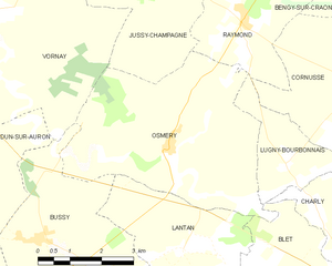
Osmery
- commune in Cher, France
- Country:
- Postal Code: 18130
- Coordinates: 46° 56' 5" N, 2° 39' 18" E
- GPS tracks (wikiloc): [Link]
- Area: 21.27 sq km
- Population: 274
- Web site: [Link]

Blet
- commune in Cher, France
- Country:
- Postal Code: 18350
- Coordinates: 46° 53' 43" N, 2° 43' 53" E
- GPS tracks (wikiloc): [Link]
- Area: 30.08 sq km
- Population: 587

Chalivoy-Milon
- commune in Cher, France
- Country:
- Postal Code: 18130
- Coordinates: 46° 51' 34" N, 2° 42' 20" E
- GPS tracks (wikiloc): [Link]
- Area: 19.61 sq km
- Population: 442