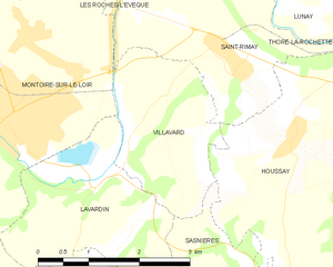
Lavardin (Lavardin)

- commune in Loir-et-Cher, France
- Country:

- Postal Code: 41800
- Coordinates: 47° 44' 31" N, 0° 53' 10" E


- GPS tracks (wikiloc): [Link]
- Area: 6.71 sq km
- Population: 188
- Web site: http://www.lavardin.net
- Wikipedia en: wiki(en)
- Wikipedia: wiki(fr)
- Wikidata storage: Wikidata: Q258911
- Wikipedia Commons Category: [Link]
- Freebase ID: [/m/0bl6tk]
- GeoNames ID: Alt: [6434032]
- SIREN number: [214101131]
- BnF ID: [15259388g]
- VIAF ID: Alt: [245833606]
- Digital Atlas of the Roman Empire ID: [3634]
- INSEE municipality code: 41113
Shares border with regions:


Saint-Martin-des-Bois
- commune in Loir-et-Cher, France
- Country:
- Postal Code: 41800
- Coordinates: 47° 43' 21" N, 0° 49' 38" E
- GPS tracks (wikiloc): [Link]
- Area: 36.4 sq km
- Population: 601

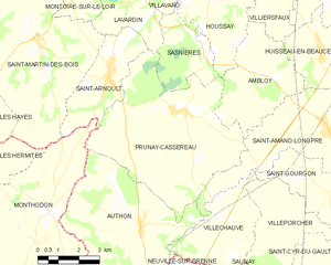
Prunay-Cassereau
- commune in Loir-et-Cher, France
- Country:
- Postal Code: 41310
- Coordinates: 47° 41' 43" N, 0° 55' 16" E
- GPS tracks (wikiloc): [Link]
- Area: 32.85 sq km
- Population: 623
- Web site: [Link]
Sasnières
- commune in Loir-et-Cher, France
- Country:
- Postal Code: 41310
- Coordinates: 47° 43' 6" N, 0° 56' 8" E
- GPS tracks (wikiloc): [Link]
- Area: 7.83 sq km
- Population: 107

Villavard
- commune in Loir-et-Cher, France
- Country:
- Postal Code: 41800
- Coordinates: 47° 45' 32" N, 0° 54' 18" E
- GPS tracks (wikiloc): [Link]
- Area: 5.18 sq km
- Population: 127
Saint-Arnoult
- commune in Loir-et-Cher, France
- Country:
- Postal Code: 41800
- Coordinates: 47° 42' 27" N, 0° 52' 22" E
- GPS tracks (wikiloc): [Link]
- Area: 9.57 sq km
- Population: 318

Montoire-sur-le-Loir
- commune in Loir-et-Cher, France
- Country:
- Postal Code: 41800
- Coordinates: 47° 45' 15" N, 0° 51' 49" E
- GPS tracks (wikiloc): [Link]
- Area: 21.02 sq km
- Population: 3822
- Web site: [Link]