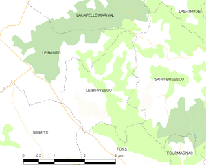
Le Bourg (Le Bourg)

- commune in Lot, France
- Country:

- Postal Code: 46120
- Coordinates: 44° 42' 34" N, 1° 54' 12" E


- GPS tracks (wikiloc): [Link]
- Area: 13.15 sq km
- Population: 320
- Wikipedia en: wiki(en)
- Wikipedia: wiki(fr)
- Wikidata storage: Wikidata: Q1106408
- Wikipedia Commons Category: [Link]
- Freebase ID: [/m/03nwk6h]
- GeoNames ID: Alt: [3005096]
- SIREN number: [214600348]
- BnF ID: [152607758]
- INSEE municipality code: 46034
Shares border with regions:

Le Bouyssou
- commune in Lot, France
- Country:
- Postal Code: 46120
- Coordinates: 44° 41' 32" N, 1° 56' 34" E
- GPS tracks (wikiloc): [Link]
- Area: 5.62 sq km
- Population: 143

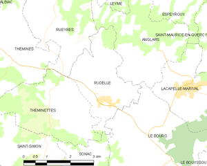
Rudelle
- commune in Lot, France
- Country:
- Postal Code: 46120
- Coordinates: 44° 43' 22" N, 1° 52' 44" E
- GPS tracks (wikiloc): [Link]
- Area: 6.83 sq km
- Population: 166


Sonac
- commune in Lot, France
- Country:
- Postal Code: 46320
- Coordinates: 44° 41' 47" N, 1° 51' 35" E
- GPS tracks (wikiloc): [Link]
- Area: 7.34 sq km
- Population: 83

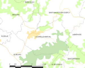
Lacapelle-Marival
- commune in Lot, France
- Country:
- Postal Code: 46120
- Coordinates: 44° 43' 44" N, 1° 55' 33" E
- GPS tracks (wikiloc): [Link]
- Area: 11.61 sq km
- Population: 1287


Anglars
- commune in Lot, France
- Country:
- Postal Code: 46120
- Coordinates: 44° 44' 23" N, 1° 54' 20" E
- GPS tracks (wikiloc): [Link]
- Area: 9.99 sq km
- Population: 211


Assier
- commune in Lot, France
- Country:
- Postal Code: 46320
- Coordinates: 44° 40' 31" N, 1° 52' 36" E
- GPS tracks (wikiloc): [Link]
- Area: 16.49 sq km
- Population: 669


Issepts
- commune in Lot, France
- Country:
- Postal Code: 46320
- Coordinates: 44° 40' 30" N, 1° 55' 33" E
- GPS tracks (wikiloc): [Link]
- Area: 9.15 sq km
- Population: 222