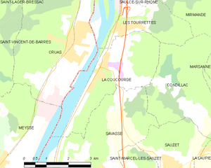
Les Tourrettes (Les Tourrettes)
- commune in Drôme, France
Les Tourrettes is a charming area in the Provence-Alpes-Côte d'Azur region of France, known for its picturesque landscapes and mild Mediterranean climate. While the area may not be as famous for hiking as some of its neighboring regions, it still offers opportunities for those looking to explore the natural beauty of southern France.
Key Hiking Features in Les Tourrettes:
-
Scenic Trails: The hiking trails around Les Tourrettes often lead through vineyards, olive groves, and beautiful forests. You can enjoy views of the surrounding hills and valleys, making it perfect for photography and nature enthusiasts.
-
Historical Sites: Some hikes may take you to nearby historical sites, including ancient ruins and charming villages, allowing you to immerse yourself in the local culture while enjoying the outdoors.
-
Mild Climate: The Mediterranean climate ensures that outdoor activities can be enjoyed throughout much of the year. Spring and autumn are particularly pleasant for hiking, with mild temperatures and blossoming nature.
-
Wildlife and Flora: The region is rich in biodiversity, so hikers may encounter various plants and wildlife, adding to the experience of walking through these landscapes.
-
Nearby Destinations: Les Tourrettes is conveniently located near other notable hiking areas such as the Drôme Valley and the Vercors Regional Natural Park, offering even more trail options and varying levels of difficulty.
Tips for Hiking in Les Tourrettes:
- Trail Maps: It's a good idea to carry a map or use a hiking app to navigate the trails, as signage can vary.
- Stay Hydrated: Always bring enough water, especially during warmer months, as some trails may be exposed to sunlight.
- Dress Appropriately: Wear comfortable hiking shoes and dress in layers to accommodate changing weather conditions.
- Respect Nature: Follow Leave No Trace principles to preserve the beauty of the area.
Consider visiting local tourism offices or outdoor shops for current trail information, guided hikes, or to inquire about any organized hiking events that might be happening during your visit. Happy hiking!
- Country:

- Postal Code: 26740
- Coordinates: 44° 39' 41" N, 4° 47' 22" E


- GPS tracks (wikiloc): [Link]
- Area: 7.34 sq km
- Population: 1042
- Web site: http://www.lestourrettes.fr/
- Wikipedia en: wiki(en)
- Wikipedia: wiki(fr)
- Wikidata storage: Wikidata: Q269141
- Wikipedia Commons Category: [Link]
- Freebase ID: [/m/03mhlky]
- Freebase ID: [/m/03mhlky]
- GeoNames ID: Alt: [6616266]
- GeoNames ID: Alt: [6616266]
- SIREN number: [212603534]
- SIREN number: [212603534]
- BnF ID: [15253213v]
- BnF ID: [15253213v]
- INSEE municipality code: 26353
- INSEE municipality code: 26353
Shares border with regions:


Saulce-sur-Rhône
- commune in Drôme, France
Saulce-sur-Rhône is a charming commune located in the Drôme department in southeastern France. It offers a beautiful natural setting for those who enjoy hiking, particularly due to its proximity to the Rhône River and the picturesque landscapes of the surrounding region....
- Country:

- Postal Code: 26270
- Coordinates: 44° 42' 13" N, 4° 47' 57" E


- GPS tracks (wikiloc): [Link]
- Area: 18.43 sq km
- Population: 1844
- Web site: [Link]

Baix
- commune in Ardèche, France
- Country:

- Postal Code: 07210
- Coordinates: 44° 42' 45" N, 4° 45' 50" E


- GPS tracks (wikiloc): [Link]
- Area: 17.39 sq km
- Population: 1076

Cruas
- commune in Ardèche, France
- Country:

- Postal Code: 07350
- Coordinates: 44° 39' 25" N, 4° 45' 47" E


- GPS tracks (wikiloc): [Link]
- Area: 15.45 sq km
- Population: 2976
- Web site: [Link]


La Coucourde
- commune in Drôme, France
La Coucourde, nestled in the Drôme department of the Auvergne-Rhône-Alpes region in southeastern France, offers a picturesque setting for hiking enthusiasts. The area is characterized by its stunning landscapes, diverse terrain, and rich biodiversity, making it an excellent choice for both casual hikers and more experienced trekkers....
- Country:

- Postal Code: 26740
- Coordinates: 44° 39' 2" N, 4° 47' 1" E


- GPS tracks (wikiloc): [Link]
- Area: 11.15 sq km
- Population: 1039


Mirmande
- commune in Drôme, France
Mirmande is a charming village located in the Drôme region of southeastern France. Known for its picturesque views and medieval architecture, Mirmande is also surrounded by beautiful natural landscapes that offer excellent hiking opportunities....
- Country:

- Postal Code: 26270
- Coordinates: 44° 41' 54" N, 4° 50' 8" E


- GPS tracks (wikiloc): [Link]
- Area: 26.45 sq km
- Population: 553
- Web site: [Link]


Condillac
- commune in Drôme, France
Condillac, located in the Drôme department in southeastern France, offers a variety of hiking opportunities thanks to its picturesque landscapes and varied terrain. The region is characterized by gentle hills, forests, and beautiful views of the Rhône Valley and surrounding mountains....
- Country:

- Postal Code: 26740
- Coordinates: 44° 38' 15" N, 4° 48' 45" E


- GPS tracks (wikiloc): [Link]
- Area: 9.57 sq km
- Population: 141

