Longuyon (Longuyon)

- commune in Meurthe-et-Moselle, France
- Country:

- Postal Code: 54260
- Coordinates: 49° 26' 49" N, 5° 36' 2" E


- GPS tracks (wikiloc): [Link]
- Area: 29.7 sq km
- Population: 5397
- Web site: http://www.longuyon.fr
- Wikipedia en: wiki(en)
- Wikipedia: wiki(fr)
- Wikidata storage: Wikidata: Q659931
- Wikipedia Commons Category: [Link]
- Freebase ID: [/m/0dsgz2]
- Freebase ID: [/m/0dsgz2]
- Freebase ID: [/m/0dsgz2]
- GeoNames ID: Alt: [2997646]
- GeoNames ID: Alt: [2997646]
- GeoNames ID: Alt: [2997646]
- SIREN number: [215403221]
- SIREN number: [215403221]
- SIREN number: [215403221]
- BnF ID: [15264391c]
- BnF ID: [15264391c]
- BnF ID: [15264391c]
- VIAF ID: Alt: [151278375]
- VIAF ID: Alt: [151278375]
- VIAF ID: Alt: [151278375]
- Library of Congress authority ID: Alt: [n81048585]
- Library of Congress authority ID: Alt: [n81048585]
- Library of Congress authority ID: Alt: [n81048585]
- WOEID: [608590]
- WOEID: [608590]
- WOEID: [608590]
- INSEE municipality code: 54322
- INSEE municipality code: 54322
- INSEE municipality code: 54322
Shares border with regions:

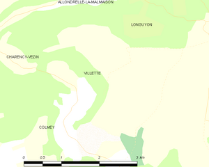
Villette
- commune in Meurthe-et-Moselle, France
- Country:
- Postal Code: 54260
- Coordinates: 49° 28' 29" N, 5° 32' 45" E
- GPS tracks (wikiloc): [Link]
- Area: 4.63 sq km
- Population: 183


Viviers-sur-Chiers
- commune in Meurthe-et-Moselle, France
- Country:
- Postal Code: 54260
- Coordinates: 49° 28' 23" N, 5° 38' 1" E
- GPS tracks (wikiloc): [Link]
- Area: 16.24 sq km
- Population: 640


Allondrelle-la-Malmaison
- commune in Meurthe-et-Moselle, France
- Country:
- Postal Code: 54260
- Coordinates: 49° 30' 37" N, 5° 33' 48" E
- GPS tracks (wikiloc): [Link]
- Area: 13.61 sq km
- Population: 635
- Web site: [Link]


Grand-Failly
- commune in Meurthe-et-Moselle, France
- Country:
- Postal Code: 54260
- Coordinates: 49° 25' 14" N, 5° 30' 52" E
- GPS tracks (wikiloc): [Link]
- Area: 21.87 sq km
- Population: 307


Sorbey
- commune in Meuse, France
- Country:
- Postal Code: 55230
- Coordinates: 49° 23' 44" N, 5° 34' 44" E
- GPS tracks (wikiloc): [Link]
- AboveSeaLevel: 230 м m
- Area: 12.42 sq km
- Population: 263

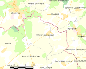
Arrancy-sur-Crusne
- commune in Meuse, France
- Country:
- Postal Code: 55230
- Coordinates: 49° 24' 49" N, 5° 39' 31" E
- GPS tracks (wikiloc): [Link]
- AboveSeaLevel: 288 м m
- Area: 20.16 sq km
- Population: 493


Beuveille
- commune in Meurthe-et-Moselle, France
- Country:
- Postal Code: 54620
- Coordinates: 49° 25' 55" N, 5° 41' 25" E
- GPS tracks (wikiloc): [Link]
- Area: 11.9 sq km
- Population: 772


Tellancourt
- commune in Meurthe-et-Moselle, France
- Country:
- Postal Code: 54260
- Coordinates: 49° 30' 29" N, 5° 38' 0" E
- GPS tracks (wikiloc): [Link]
- Area: 3.76 sq km
- Population: 551

Charency-Vezin
- commune in Meurthe-et-Moselle, France
- Country:
- Postal Code: 54260
- Coordinates: 49° 28' 58" N, 5° 30' 39" E
- GPS tracks (wikiloc): [Link]
- Area: 14.79 sq km
- Population: 652


Colmey
- commune in Meurthe-et-Moselle, France
- Country:
- Postal Code: 54260
- Coordinates: 49° 27' 28" N, 5° 33' 27" E
- GPS tracks (wikiloc): [Link]
- Area: 9.9 sq km
- Population: 259