Lorrez-le-Bocage-Préaux (Lorrez-le-Bocage-Préaux)

- commune in Seine-et-Marne, France
- Country:

- Postal Code: 77710
- Coordinates: 48° 14' 13" N, 2° 54' 3" E


- GPS tracks (wikiloc): [Link]
- Area: 19.9 sq km
- Population: 1291
- Web site: http://www.lorrez-le-bocage-preaux.fr
- Wikipedia en: wiki(en)
- Wikipedia: wiki(fr)
- Wikidata storage: Wikidata: Q1459990
- Wikipedia Commons Category: [Link]
- Freebase ID: [/m/02qys4l]
- Freebase ID: [/m/02qys4l]
- GeoNames ID: Alt: [2997548]
- GeoNames ID: Alt: [2997548]
- SIREN number: [217702612]
- SIREN number: [217702612]
- BnF ID: [15275601v]
- BnF ID: [15275601v]
- INSEE municipality code: 77261
- INSEE municipality code: 77261
Shares border with regions:


Chevry-en-Sereine
- commune in Seine-et-Marne, France
- Country:
- Postal Code: 77710
- Coordinates: 48° 15' 13" N, 2° 56' 35" E
- GPS tracks (wikiloc): [Link]
- Area: 22.81 sq km
- Population: 517
- Web site: [Link]

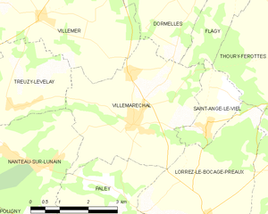
Villemaréchal
- commune in Seine-et-Marne, France
- Country:
- Postal Code: 77710
- Coordinates: 48° 16' 3" N, 2° 52' 6" E
- GPS tracks (wikiloc): [Link]
- Area: 14.23 sq km
- Population: 862
- Web site: [Link]


Égreville
- commune in Seine-et-Marne, France
- Country:
- Postal Code: 77620
- Coordinates: 48° 10' 38" N, 2° 52' 17" E
- GPS tracks (wikiloc): [Link]
- Area: 31.84 sq km
- Population: 2159
- Web site: [Link]


Paley
- commune in Seine-et-Marne, France
- Country:
- Postal Code: 77710
- Coordinates: 48° 14' 30" N, 2° 51' 34" E
- GPS tracks (wikiloc): [Link]
- Area: 9.26 sq km
- Population: 427
- Web site: [Link]


Remauville
- commune in Seine-et-Marne, France
- Country:
- Postal Code: 77710
- Coordinates: 48° 12' 49" N, 2° 49' 24" E
- GPS tracks (wikiloc): [Link]
- Area: 10.88 sq km
- Population: 463


Vaux-sur-Lunain
- commune in Seine-et-Marne, France
- Country:
- Postal Code: 77710
- Coordinates: 48° 13' 39" N, 2° 56' 8" E
- GPS tracks (wikiloc): [Link]
- Area: 8.47 sq km
- Population: 211

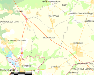
Chaintreaux
- commune in Seine-et-Marne, France
- Country:
- Postal Code: 77460
- Coordinates: 48° 11' 59" N, 2° 49' 10" E
- GPS tracks (wikiloc): [Link]
- Area: 23.92 sq km
- Population: 918

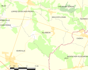
Villebéon
- commune in Seine-et-Marne, France
- Country:
- Postal Code: 77710
- Coordinates: 48° 12' 31" N, 2° 56' 24" E
- GPS tracks (wikiloc): [Link]
- Area: 16.45 sq km
- Population: 480


Thoury-Férottes
- commune in Seine-et-Marne, France
- Country:
- Postal Code: 77940
- Coordinates: 48° 17' 29" N, 2° 56' 32" E
- GPS tracks (wikiloc): [Link]
- Area: 16.49 sq km
- Population: 677
- Web site: [Link]


Saint-Ange-le-Viel
- commune in Seine-et-Marne, France
- Country:
- Postal Code: 77710
- Coordinates: 48° 15' 56" N, 2° 54' 4" E
- GPS tracks (wikiloc): [Link]
- AboveSeaLevel: 119 м m
- Area: 3.23 sq km
- Population: 234