Lourouer-Saint-Laurent (Lourouer-Saint-Laurent)

- commune in Indre, France
- Country:

- Postal Code: 36400
- Coordinates: 46° 37' 24" N, 2° 0' 46" E


- GPS tracks (wikiloc): [Link]
- Area: 11.21 sq km
- Population: 273
- Wikipedia en: wiki(en)
- Wikipedia: wiki(fr)
- Wikidata storage: Wikidata: Q1137531
- Wikipedia Commons Category: [Link]
- Freebase ID: [/m/0c08fc]
- GeoNames ID: Alt: [2997378]
- SIREN number: [213601008]
- BnF ID: [15257404d]
- VIAF ID: Alt: [151667323]
- Library of Congress authority ID: Alt: [no2009019254]
- INSEE municipality code: 36100
Shares border with regions:


Verneuil-sur-Igneraie
- commune in Indre, France
- Country:
- Postal Code: 36400
- Coordinates: 46° 39' 18" N, 2° 0' 38" E
- GPS tracks (wikiloc): [Link]
- Area: 9.84 sq km
- Population: 318


Lacs
- commune in Indre, France
- Country:
- Postal Code: 36400
- Coordinates: 46° 35' 7" N, 2° 1' 26" E
- GPS tracks (wikiloc): [Link]
- Area: 13.46 sq km
- Population: 661

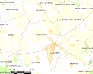
Montgivray
- commune in Indre, France
- Country:
- Postal Code: 36400
- Coordinates: 46° 36' 12" N, 1° 58' 57" E
- GPS tracks (wikiloc): [Link]
- Area: 25.48 sq km
- Population: 1634
- Web site: [Link]

Thevet-Saint-Julien
- commune in Indre, France
- Country:
- Postal Code: 36400
- Coordinates: 46° 38' 14" N, 2° 4' 8" E
- GPS tracks (wikiloc): [Link]
- Area: 30.94 sq km
- Population: 402

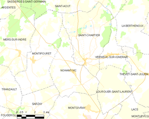
Nohant-Vic
- commune in Indre, France
- Country:
- Postal Code: 36400
- Coordinates: 46° 38' 19" N, 1° 57' 36" E
- GPS tracks (wikiloc): [Link]
- Area: 21.25 sq km
- Population: 463
- Web site: [Link]