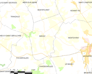
Nohant-Vic (Nohant-Vic)

- commune in Indre, France
- Country:

- Postal Code: 36400
- Coordinates: 46° 38' 19" N, 1° 57' 36" E


- GPS tracks (wikiloc): [Link]
- Area: 21.25 sq km
- Population: 463
- Web site: http://www.nohantvic.fr
- Wikipedia en: wiki(en)
- Wikipedia: wiki(fr)
- Wikidata storage: Wikidata: Q656447
- Wikipedia Commons Category: [Link]
- Freebase ID: [/m/03wp58]
- SIREN number: [213601438]
- BnF ID: [15257447p]
- VIAF ID: Alt: [244148300]
- GND ID: Alt: [4212868-7]
- NKCR AUT ID: [ge1007329]
- INSEE municipality code: 36143
Shares border with regions:


Verneuil-sur-Igneraie
- commune in Indre, France
- Country:
- Postal Code: 36400
- Coordinates: 46° 39' 18" N, 2° 0' 38" E
- GPS tracks (wikiloc): [Link]
- Area: 9.84 sq km
- Population: 318

Sarzay
- commune in Indre, France
- Country:
- Postal Code: 36230
- Coordinates: 46° 36' 6" N, 1° 54' 16" E
- GPS tracks (wikiloc): [Link]
- Area: 18.3 sq km
- Population: 319

Montipouret
- commune in Indre, France
- Country:
- Postal Code: 36230
- Coordinates: 46° 38' 58" N, 1° 54' 1" E
- GPS tracks (wikiloc): [Link]
- Area: 27.89 sq km
- Population: 565


Lourouer-Saint-Laurent
- commune in Indre, France
- Country:
- Postal Code: 36400
- Coordinates: 46° 37' 24" N, 2° 0' 46" E
- GPS tracks (wikiloc): [Link]
- Area: 11.21 sq km
- Population: 273

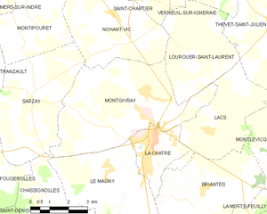
Montgivray
- commune in Indre, France
- Country:
- Postal Code: 36400
- Coordinates: 46° 36' 12" N, 1° 58' 57" E
- GPS tracks (wikiloc): [Link]
- Area: 25.48 sq km
- Population: 1634
- Web site: [Link]


Saint-Chartier
- commune in Indre, France
- Country:
- Postal Code: 36400
- Coordinates: 46° 38' 59" N, 1° 58' 38" E
- GPS tracks (wikiloc): [Link]
- Area: 27.52 sq km
- Population: 532