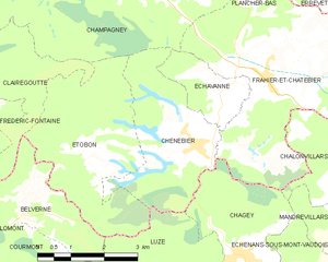
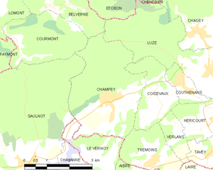
Luze, Haute-Saône (Luze)

- commune in Haute-Saône, France
 Hiking in Luze, Haute-Saône
Luze is a charming commune located in the Haute-Saône department in eastern France, known for its picturesque landscapes and opportunities for outdoor activities, including hiking. The area is characterized by rolling hills, lush forests, and scenic countryside, making it a great destination for hiking enthusiasts.
Hiking Trails
While specific trail maps may vary, there are several well-marked paths around Luze that cater to various skill levels, from easy strolls to more challenging hikes. Some popular routes include:
-
Local Countryside Trails: These often lead walkers through vineyards, orchards, and fields, offering a chance to enjoy the peaceful rural environment.
-
Forest Trails: The surrounding woodlands provide opportunities for shaded hikes, where you might encounter local wildlife and diverse flora.
-
Luze to Nearby Villages: You can find routes that connect Luze with nearby villages, allowing for longer day hikes and the chance to explore more of the Haute-Saône region.
Flora and Fauna
The area around Luze is rich in biodiversity, with various species of trees, plants, and wildlife. Keep an eye out for birds and small mammals, as well as wildflowers in spring and summer.
Tips for Hiking in Luze
- Weather: Since weather conditions can change, always check the forecast before heading out. Dress in layers and prepare for rain if necessary.
- Footwear: Wear sturdy, comfortable hiking boots to navigate different terrains effectively.
- Hydration: Carry enough water, especially on warmer days, to stay hydrated during your hikes.
- Trail Maps: It’s advisable to have a physical or digital map of the trails in the area, as some routes may not be well marked.
Local Amenities
After a day of hiking, you can enjoy local cuisine in Luze, where you may find small cafes and restaurants serving regional dishes. Visiting local farms or markets can also be a delightful way to experience the area's culture.
Overall, hiking in Luze provides a wonderful opportunity to enjoy nature, experience the tranquility of the French countryside, and discover the rich cultural history of the Haute-Saône region.
- Country:

- Postal Code: 70400
- Coordinates: 47° 35' 49" N, 6° 44' 23" E


- GPS tracks (wikiloc): [Link]
- Area: 10.69 sq km
- Population: 711
- Wikipedia en: wiki(en)
- Wikipedia: wiki(fr)
- Wikidata storage: Wikidata: Q513279
- Wikipedia Commons Category: [Link]
- Freebase ID: [/m/03ntfm0]
- GeoNames ID: Alt: [6441989]
- SIREN number: [217003128]
- BnF ID: [15272704f]
- PACTOLS thesaurus ID: [pcrt0SzVdRSU6p]
- INSEE municipality code: 70312
Shares border with regions:


Échenans-sous-Mont-Vaudois
- commune in Haute-Saône, France
Hiking in Échenans-sous-Mont-Vaudois
Échenans-sous-Mont-Vaudois, located in the Bourgogne-Franche-Comté region of France, offers a serene and scenic environment for hiking enthusiasts. While it may not be one of the most prominent hiking destinations, it provides a peaceful escape into nature, particularly for those who enjoy exploring less crowded trails....
- Country:
- Postal Code: 70400
- Coordinates: 47° 36' 10" N, 6° 46' 18" E
- GPS tracks (wikiloc): [Link]
- AboveSeaLevel: 381 м m
- Area: 5.44 sq km
- Population: 499


Étobon
- commune in Haute-Saône, France
- Country:
- Postal Code: 70400
- Coordinates: 47° 38' 36" N, 6° 40' 35" E
- GPS tracks (wikiloc): [Link]
- Area: 12.26 sq km
- Population: 298

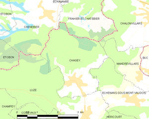
Chagey
- commune in Haute-Saône, France
Hiking in Chagey
Chagey, located in the Haute-Saône department of France, offers a unique hiking experience characterized by its picturesque landscapes and natural beauty. While it is a small village, the surrounding area provides various trails that showcase the region's charming countryside, including rolling hills, forests, and rivers....
- Country:
- Postal Code: 70400
- Coordinates: 47° 36' 43" N, 6° 44' 6" E
- GPS tracks (wikiloc): [Link]
- Area: 6.99 sq km
- Population: 651


Couthenans
- commune in Haute-Saône, France
Hiking in Couthenans
Couthenans is not widely recognized as a hiking destination, so it's possible that there might be a typo or confusion with the name of a location. If you meant "Couthenans" to refer to a specific area, it would be helpful to have more context such as the country or region it's located in....
- Country:
- Postal Code: 70400
- Coordinates: 47° 35' 26" N, 6° 43' 31" E
- GPS tracks (wikiloc): [Link]
- Area: 1.64 sq km
- Population: 748
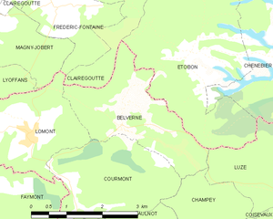
Belverne
- commune in Haute-Saône, France
- Country:
- Postal Code: 70400
- Coordinates: 47° 37' 51" N, 6° 39' 3" E
- GPS tracks (wikiloc): [Link]
- Area: 6.15 sq km
- Population: 144
- Web site: [Link]

Chenebier
- commune in Haute-Saône, France
- Country:
- Postal Code: 70400
- Coordinates: 47° 38' 30" N, 6° 43' 7" E
- GPS tracks (wikiloc): [Link]
- Area: 9.05 sq km
- Population: 706
- Web site: [Link]

Champey
- commune in Haute-Saône, France
Hiking in Champey
Hiking in Champey, also known as Champasak, is a wonderful experience, particularly for those looking to explore the natural beauty and cultural heritage of southern Laos. Here are some key points to consider:...
- Country:
- Postal Code: 70400
- Coordinates: 47° 35' 5" N, 6° 40' 50" E
- GPS tracks (wikiloc): [Link]
- Area: 11.3 sq km
- Population: 874


Coisevaux
- commune in Haute-Saône, France
Hiking in Coisevaux
Coisevaux, located in the scenic Jura region of France, offers an excellent environment for hiking enthusiasts. The Jura mountains are known for their diverse landscapes, which include lush forests, rolling hills, and stunning viewpoints overlooking valleys....
- Country:
- Postal Code: 70400
- Coordinates: 47° 34' 47" N, 6° 42' 22" E
- GPS tracks (wikiloc): [Link]
- Area: 4.18 sq km
- Population: 341