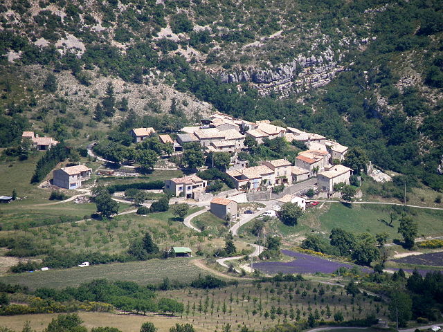
Mévouillon (Mévouillon)

- commune in Drôme, France
 Hiking in Mévouillon
Mévouillon is a small village located in the Drôme department of southeastern France, nestled in the picturesque landscapes of the Provençal countryside. This region is known for its beautiful hiking trails that offer both seasoned hikers and casual walkers an opportunity to explore its natural beauty.
Key Highlights for Hiking in Mévouillon:
-
Scenic Trails: The area around Mévouillon features a variety of trails that wind through lush forests, rolling hills, and vineyards. Hikers can enjoy views of the surrounding mountains and valleys, making it a perfect spot for both leisurely walks and more challenging hikes.
-
Biodiversity: The region is rich in flora and fauna, providing a great opportunity for nature lovers to observe diverse wildlife and plant species. Bring your binoculars if you're interested in birdwatching!
-
Local Attractions: While hiking, you might encounter local historical sites, such as charming old churches, ruins, and traditional farms. The nearby village of Nyons is known for its olive oil and could make a nice stop during your hike.
-
Weather Considerations: The best times to hike around Mévouillon are during spring and fall when temperatures are mild, and the landscapes are particularly vibrant. Summer can get hot, so early morning hikes are recommended.
-
Trail Maps and Guides: It's advisable to have a good map or utilize a hiking app that details the trails in the region. Local tourist offices can provide maps and additional resources.
-
Safety Tips: As with any hiking adventure, ensure you are well-prepared. Bring plenty of water, wear appropriate footwear, and let someone know your hiking plans. Be mindful of the terrain and weather conditions.
-
Accessibility: Most trails are accessible to varying levels of hikers, but it's always good to check the trail difficulty and distance before setting out.
Conclusion
Hiking in Mévouillon offers a unique blend of natural beauty, cultural experiences, and adventure. Whether you are looking for a peaceful walk through nature or a challenging trek, Mévouillon has something to offer. Always remember to respect the environment and leave no trace! Happy hiking!
- Country:

- Postal Code: 26560
- Coordinates: 44° 14' 30" N, 5° 27' 52" E


- GPS tracks (wikiloc): [Link]
- Area: 29.09 sq km
- Population: 246
- Wikipedia en: wiki(en)
- Wikipedia: wiki(fr)
- Wikidata storage: Wikidata: Q470896
- Wikipedia Commons Category: [Link]
- Freebase ID: [/m/03mhj35]
- GeoNames ID: Alt: [6430124]
- SIREN number: [212601819]
- BnF ID: [15253042w]
- VIAF ID: Alt: [249116835]
- INSEE municipality code: 26181
Shares border with regions:

La Rochette-du-Buis
- commune in Drôme, France
Hiking in La Rochette-du-Buis
La Rochette-du-Buis is a picturesque village located in the Drôme department of France, part of the Auvergne-Rhône-Alpes region. It is surrounded by stunning natural landscapes, making it an ideal location for hiking enthusiasts....
- Country:
- Postal Code: 26170
- Coordinates: 44° 16' 9" N, 5° 25' 13" E
- GPS tracks (wikiloc): [Link]
- Area: 10.36 sq km
- Population: 78

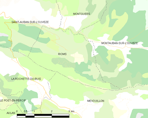
Rioms
- commune in Drôme, France
Hiking in Rioms
Rioms is a picturesque destination in France known for its stunning landscapes and hiking opportunities. The area features a mix of rolling hills, forests, and scenic views, making it a great spot for both casual walkers and experienced hikers....
- Country:
- Postal Code: 26170
- Coordinates: 44° 16' 24" N, 5° 27' 34" E
- GPS tracks (wikiloc): [Link]
- Area: 9.39 sq km
- Population: 26


Villefranche-le-Château
- commune in Drôme, France
Hiking in Villefranche-le-Château
Villefranche-le-Château, located in the beautiful region of France, offers a variety of hiking opportunities amidst picturesque landscapes. The surrounding areas are characterized by rolling hills, dense forests, and charming rural settings, making it a great destination for outdoor enthusiasts....
- Country:
- Postal Code: 26560
- Coordinates: 44° 13' 16" N, 5° 31' 21" E
- GPS tracks (wikiloc): [Link]
- Area: 7.42 sq km
- Population: 24

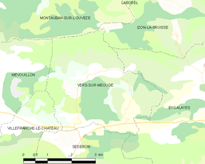
Vers-sur-Méouge
- commune in Drôme, France
Hiking in Vers-sur-Méouge
Vers-sur-Méouge is a charming village located in the Drôme department in southeastern France, known for its natural beauty and outdoor activities, particularly hiking. The surrounding region features stunning landscapes, including the picturesque Méouge River, limestone cliffs, and the scenic backdrop of the Baronnies Provençales Natural Regional Park....
- Country:
- Postal Code: 26560
- Coordinates: 44° 13' 51" N, 5° 34' 14" E
- GPS tracks (wikiloc): [Link]
- Area: 13.81 sq km
- Population: 47


Barret-de-Lioure
- commune in Drôme, France
Hiking in Barret-de-Lioure
Barret-de-Lioure is a picturesque village located in the Drôme department of southeastern France. It is surrounded by stunning natural landscapes that provide excellent opportunities for hiking and outdoor activities. Here are some key points to consider if you're planning a hiking trip in or around Barret-de-Lioure:...
- Country:
- Postal Code: 26570
- Coordinates: 44° 11' 10" N, 5° 29' 37" E
- GPS tracks (wikiloc): [Link]
- Area: 34.64 sq km
- Population: 86


Montauban-sur-l'Ouvèze
- commune in Drôme, France
Hiking in Montauban-sur-l'Ouvèze
Montauban-sur-l'Ouvèze is a charming village located in the Drôme department in southeastern France, nestled in the picturesque region of the Vercors. The area is known for its stunning natural landscapes, making it a great destination for hiking enthusiasts....
- Country:
- Postal Code: 26170
- Coordinates: 44° 16' 28" N, 5° 30' 8" E
- GPS tracks (wikiloc): [Link]
- Area: 32.29 sq km
- Population: 107

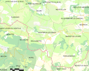
Montbrun-les-Bains
- commune in Drôme, France
Hiking in Montbrun-les-Bains
Montbrun-les-Bains is a charming village located in the Drôme department of southeastern France, nestled in the foothills of the Mont Ventoux. This picturesque area is known for its stunning landscapes, thermal springs, and rich history, making it a great destination for hiking enthusiasts....
- Country:
- Postal Code: 26570
- Coordinates: 44° 10' 32" N, 5° 26' 35" E
- GPS tracks (wikiloc): [Link]
- Area: 33.26 sq km
- Population: 433
- Web site: [Link]


Aulan
- commune in Drôme, France
Hiking in Aulan
Aulan, located in the heart of the Rhône-Alpes region in France, offers a range of hiking opportunities that cater to various skill levels. The natural beauty of the area is characterized by its rolling hills, lush forests, and stunning mountain views, making it a charming destination for outdoor enthusiasts....
- Country:
- Postal Code: 26570
- Coordinates: 44° 13' 19" N, 5° 25' 42" E
- GPS tracks (wikiloc): [Link]
- Area: 10.55 sq km
- Population: 11