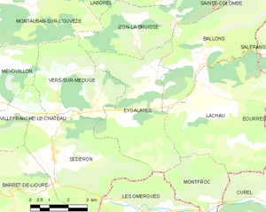
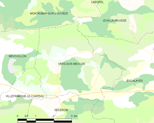
Vers-sur-Méouge (Vers-sur-Méouge)
- commune in Drôme, France
Vers-sur-Méouge is a charming village located in the Drôme department in southeastern France, known for its natural beauty and outdoor activities, particularly hiking. The surrounding region features stunning landscapes, including the picturesque Méouge River, limestone cliffs, and the scenic backdrop of the Baronnies Provençales Natural Regional Park.
Here are some highlights about hiking in Vers-sur-Méouge:
Trails and Routes
-
River Trails: You can find numerous trails that follow the banks of the Méouge River. These trails typically offer gentle terrain and are suitable for families and less experienced hikers, providing beautiful views of the river and surrounding nature.
-
Circular Trails: There are various circular hiking routes that allow you to explore the countryside, including vineyards and forests. Many of these routes are well-marked and provide a good mix of elevation gain and scenic vistas.
-
Elevation Hikes: For more experienced hikers, there are trails that lead to higher elevations, offering panoramic views of the surrounding mountains and valleys. Be aware that these paths can be more challenging, so proper hiking gear and experience are recommended.
Flora and Fauna
The area around Vers-sur-Méouge is rich in biodiversity, with a variety of flora and fauna. You may encounter various bird species, wildflowers, and even some wildlife as you hike through the diverse ecosystems.
Seasonal Considerations
- Spring and Summer: These seasons are ideal for hiking due to mild weather and blooming wildflowers. Summer can be hot, so early morning hikes are recommended.
- Autumn: Fall offers beautiful foliage and is often a quiet time to hike as the summer crowds diminish.
- Winter: Some lower elevation trails may be accessible, but always check conditions and be prepared for colder temperatures.
Local Culture and Amenities
Vers-sur-Méouge boasts a welcoming atmosphere with local shops and eateries. After a day of hiking, you can enjoy regional cuisine, such as local cheeses, olive oil, and wines. Additionally, there may be opportunities to connect with local hiking groups or guides who can enhance your experience.
Safety Tips
- Always carry sufficient water and snacks.
- Wear appropriate clothing and hiking shoes.
- Check the weather forecast before heading out, and be prepared for changes.
- Carry a map or GPS device to navigate the trails.
In summary, hiking in Vers-sur-Méouge offers a wonderful opportunity to explore beautiful landscapes, engage with nature, and experience local culture. Whether you are a beginner or an experienced hiker, you will find trails that suit your skill level and provide memorable experiences.
- Country:

- Postal Code: 26560
- Coordinates: 44° 13' 51" N, 5° 34' 14" E


- GPS tracks (wikiloc): [Link]
- Area: 13.81 sq km
- Population: 47
- Wikipedia en: wiki(en)
- Wikipedia: wiki(fr)
- Wikidata storage: Wikidata: Q314580
- Wikipedia Commons Category: [Link]
- Freebase ID: [/m/03mhlym]
- GeoNames ID: Alt: [6430269]
- SIREN number: [212603724]
- BnF ID: [152532324]
- INSEE municipality code: 26372
Shares border with regions:


Séderon
- commune in Drôme, France
Séderon is a picturesque village located in the Drôme region of southeastern France, known for its stunning landscapes and hiking opportunities. The surrounding area offers a variety of trails that cater to different skill levels and interests, making it an ideal destination for both casual walkers and experienced hikers....
- Country:

- Postal Code: 26560
- Coordinates: 44° 12' 16" N, 5° 32' 14" E


- GPS tracks (wikiloc): [Link]
- Area: 20.3 sq km
- Population: 272


Villefranche-le-Château
- commune in Drôme, France
 Hiking in Villefranche-le-Château
Villefranche-le-Château, located in the beautiful region of France, offers a variety of hiking opportunities amidst picturesque landscapes. The surrounding areas are characterized by rolling hills, dense forests, and charming rural settings, making it a great destination for outdoor enthusiasts....
- Country:

- Postal Code: 26560
- Coordinates: 44° 13' 16" N, 5° 31' 21" E


- GPS tracks (wikiloc): [Link]
- Area: 7.42 sq km
- Population: 24


Izon-la-Bruisse
- commune in Drôme, France
Izon-la-Bruisse is a beautiful destination located in the French Alps, known for its stunning landscapes, diverse flora and fauna, and well-marked hiking trails. Here are some highlights and tips for hiking in this region:...
- Country:

- Postal Code: 26560
- Coordinates: 44° 15' 20" N, 5° 35' 36" E


- GPS tracks (wikiloc): [Link]
- Area: 14.65 sq km
- Population: 9


Montauban-sur-l'Ouvèze
- commune in Drôme, France
 Hiking in Montauban-sur-l'Ouvèze
Montauban-sur-l'Ouvèze is a charming village located in the Drôme department in southeastern France, nestled in the picturesque region of the Vercors. The area is known for its stunning natural landscapes, making it a great destination for hiking enthusiasts....
- Country:

- Postal Code: 26170
- Coordinates: 44° 16' 28" N, 5° 30' 8" E


- GPS tracks (wikiloc): [Link]
- Area: 32.29 sq km
- Population: 107


Mévouillon
- commune in Drôme, France
Mévouillon is a small village located in the Drôme department of southeastern France, nestled in the picturesque landscapes of the Provençal countryside. This region is known for its beautiful hiking trails that offer both seasoned hikers and casual walkers an opportunity to explore its natural beauty....
- Country:

- Postal Code: 26560
- Coordinates: 44° 14' 30" N, 5° 27' 52" E


- GPS tracks (wikiloc): [Link]
- Area: 29.09 sq km
- Population: 246


Eygalayes
- commune in Drôme, France
Eygaliers is a picturesque village in the Drôme department of southeastern France, nestled in the beautiful landscape of the Vercors Regional Natural Park. It offers a variety of hiking opportunities that cater to all levels of experience. Here’s a general overview of hiking in the Eygaliers area:...
- Country:

- Postal Code: 26560
- Coordinates: 44° 14' 21" N, 5° 36' 28" E


- GPS tracks (wikiloc): [Link]
- Area: 17.97 sq km
- Population: 76
- Web site: [Link]
