Mackwiller (Mackwiller)

- commune in Bas-Rhin, France
- Country:

- Postal Code: 67430
- Coordinates: 48° 55' 34" N, 7° 10' 31" E


- GPS tracks (wikiloc): [Link]
- Area: 9.02 sq km
- Population: 573
- Web site: http://www.mairie-mackwiller.fr/
- Wikipedia en: wiki(en)
- Wikipedia: wiki(fr)
- Wikidata storage: Wikidata: Q21479
- Wikipedia Commons Category: [Link]
- Freebase ID: [/m/03m996k]
- Freebase ID: [/m/03m996k]
- GeoNames ID: Alt: [6441211]
- GeoNames ID: Alt: [6441211]
- SIREN number: [216702787]
- SIREN number: [216702787]
- BnF ID: [15271420m]
- BnF ID: [15271420m]
- VIAF ID: Alt: [241904640]
- VIAF ID: Alt: [241904640]
- PACTOLS thesaurus ID: [pcrtBBqFAsMPXu]
- PACTOLS thesaurus ID: [pcrtBBqFAsMPXu]
- INSEE municipality code: 67278
- INSEE municipality code: 67278
Shares border with regions:

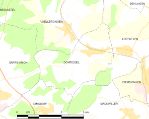
Domfessel
- commune in Bas-Rhin, France
- Country:
- Postal Code: 67430
- Coordinates: 48° 57' 4" N, 7° 9' 13" E
- GPS tracks (wikiloc): [Link]
- Area: 6.23 sq km
- Population: 299
Rexingen
- commune in Bas-Rhin, France
- Country:
- Postal Code: 67320
- Coordinates: 48° 54' 8" N, 7° 10' 53" E
- GPS tracks (wikiloc): [Link]
- Area: 2.32 sq km
- Population: 205
Rimsdorf
- commune in Bas-Rhin, France
- Country:
- Postal Code: 67260
- Coordinates: 48° 55' 46" N, 7° 7' 34" E
- GPS tracks (wikiloc): [Link]
- Area: 6.07 sq km
- Population: 313
Thal-Drulingen
- commune in Bas-Rhin, France
- Country:
- Postal Code: 67320
- Coordinates: 48° 54' 36" N, 7° 8' 44" E
- GPS tracks (wikiloc): [Link]
- Area: 5.25 sq km
- Population: 181


Waldhambach
- commune in Bas-Rhin, France
- Country:
- Postal Code: 67430
- Coordinates: 48° 55' 37" N, 7° 13' 1" E
- GPS tracks (wikiloc): [Link]
- Area: 12.59 sq km
- Population: 613
- Web site: [Link]

Diemeringen
- commune in Bas-Rhin, France
- Country:
- Postal Code: 67430
- Coordinates: 48° 56' 30" N, 7° 11' 12" E
- GPS tracks (wikiloc): [Link]
- Area: 8.81 sq km
- Population: 1625
- Web site: [Link]


Lorentzen
- commune in Bas-Rhin, France
- Country:
- Postal Code: 67430
- Coordinates: 48° 57' 9" N, 7° 10' 29" E
- GPS tracks (wikiloc): [Link]
- Area: 7.85 sq km
- Population: 229

Adamswiller
- commune in Bas-Rhin, France
- Country:
- Postal Code: 67320
- Coordinates: 48° 54' 17" N, 7° 12' 10" E
- GPS tracks (wikiloc): [Link]
- Area: 3.4 sq km
- Population: 378