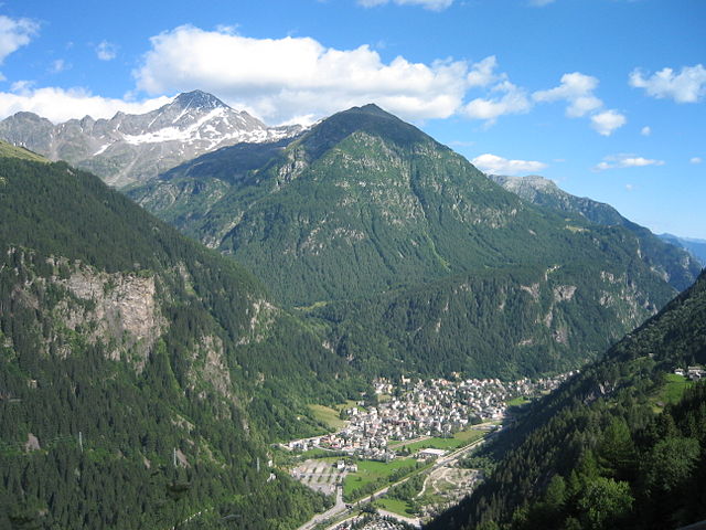
Madesimo (Madesimo)
.svg)
- Italian comune
 Hiking in Madesimo
Madesimo, located in the Lombardy region of Italy, is a popular destination for hiking, especially during the summer months when the snow melts and reveals stunning landscapes. Nestled in the Alps, Madesimo offers a variety of trails suitable for hikers of all ages and skill levels. Here are some key highlights of hiking in the area:
Scenic Trails
- Val di Lei: This picturesque valley features a mix of meadows, forests, and stunning mountain views. The trail leading to the valley is relatively easy and perfect for families.
- Sentiero del Sole: A well-marked trail that allows hikers to enjoy panoramic views of the surrounding mountains and valleys. The route is ideal for those looking for a moderate day hike.
- Pizzo Groppera: For more experienced hikers, the ascent to Pizzo Groppera offers a rewarding challenge with breathtaking views from the summit.
Flora and Fauna
The region is rich in biodiversity, and hikers can expect to see a variety of alpine flora and fauna. During your hike, keep an eye out for local wildlife, including deer, chamois, and a range of bird species.
Best Time to Hike
The best time for hiking in Madesimo is typically from late June to early September, when temperatures are mild, and the trails are generally free of snow. However, it's essential to check local conditions, as weather can vary.
Essential Tips
- Gear: Wear appropriate hiking boots, and consider bringing trekking poles, especially for steeper trails.
- Maps and Guides: Bring a physical map or download offline maps, as mobile signal may be weak on higher trails.
- Hydration and Snacks: Carry plenty of water and energy-boosting snacks, as some trails can be quite demanding.
- Weather Awareness: Always check the weather forecast before heading out, and be prepared for sudden changes, as mountain weather can be unpredictable.
Conclusion
Madesimo is a beautiful hiking destination that caters to all levels of hikers. Whether you are seeking challenging routes or relaxing walks through breathtaking scenery, Madesimo's hiking trails provide unforgettable experiences in the heart of the Alps. Make sure to explore the local culture and cuisine as well, as the area is known for its delightful mountain food!
- Country:

- Postal Code: 23024
- Local Dialing Code: 0343
- Licence Plate Code: SO
- Coordinates: 46° 26' 0" N, 9° 21' 0" E


- GPS tracks (wikiloc): [Link]
- AboveSeaLevel: 1399 м m
- Area: 85.66 sq km
- Population: 517
- Web site: http://www.comune.madesimo.so.it
- Wikipedia en: wiki(en)
- Wikipedia: wiki(it)
- Wikidata storage: Wikidata: Q40931
- Wikipedia Commons Gallery: [Link]
- Wikipedia Commons Category: [Link]
- Freebase ID: [/m/0gj35w]
- GeoNames ID: Alt: [6536119]
- VIAF ID: Alt: [249275622]
- OSM relation ID: [47199]
- archINFORM location ID: [6480]
- DMOZ ID: Alt: [Regional/Europe/Italy/Lombardy/Localities/Madesimo/]
- ISTAT ID: 014035
- Italian cadastre code: E342
Shares border with regions:

Campodolcino
- Italian comune
Hiking in Campodolcino
Campodolcino is a picturesque village located in the province of Sondrio in the Lombardy region of Italy, nestled in the heart of the Italian Alps. This area is not only known for its stunning landscapes but also for the variety of hiking opportunities it offers, catering to all levels of outdoor enthusiasts....
- Country:
- Postal Code: 23021
- Local Dialing Code: 0343
- Licence Plate Code: SO
- Coordinates: 46° 24' 18" N, 9° 21' 11" E
- GPS tracks (wikiloc): [Link]
- AboveSeaLevel: 1071 м m
- Area: 48.49 sq km
- Population: 931
- Web site: [Link]
Piuro
- Italian comune
Hiking in Piuro
Piuro is a picturesque village located in the Lombardy region of northern Italy, nestled in the Seriana Valley and close to the border with Switzerland. The area is known for its stunning natural beauty, making it a great destination for hiking enthusiasts. Here are some highlights about hiking in Piuro:...
- Country:
- Postal Code: 23020
- Local Dialing Code: 0343
- Licence Plate Code: SO
- Coordinates: 46° 19' 51" N, 9° 25' 18" E
- GPS tracks (wikiloc): [Link]
- AboveSeaLevel: 382 м m
- Area: 84.25 sq km
- Population: 1932
- Web site: [Link]


Splügen
- municipality in Graubünden, Switzerland
Hiking in Splügen
Splügen is a picturesque mountain village located in the Swiss Alps, known for its stunning scenery and outdoor activities, making it a fantastic destination for hiking enthusiasts. Here are some key points to consider when hiking in and around Splügen:...
- Country:

- Postal Code: 7435
- Local Dialing Code: 081
- Licence Plate Code: GR
- Coordinates: 46° 32' 59" N, 9° 19' 0" E
- GPS tracks (wikiloc): [Link]
- AboveSeaLevel: 1457 м m
- Area: 60.49 sq km
- Population: 432
- Web site: [Link]


Mesocco
- municipality in Switzerland
Hiking in Mesocco
Mesocco, located in the picturesque Mendrisiotto region of southern Switzerland, offers a variety of hiking opportunities that cater to different skill levels and interests. Nestled in the valley of the Moesa River, this charming area is known for its stunning landscapes, historic villages, and lush nature....
- Country:
- Postal Code: 6563
- Local Dialing Code: 091
- Licence Plate Code: GR
- Coordinates: 46° 23' 29" N, 9° 14' 15" E
- GPS tracks (wikiloc): [Link]
- AboveSeaLevel: 828 м m
- Area: 164.9 sq km
- Population: 1374
- Web site: [Link]


Sufers
- municipality in Switzerland
Hiking in Sufers
Sure! Surfers Paradise, located on the Gold Coast in Queensland, Australia, is primarily known for its stunning beaches, vibrant nightlife, and iconic skyline. While it may not be a hiking destination in the traditional sense, there are several nearby areas and activities that outdoor enthusiasts can enjoy....
- Country:
- Postal Code: 7434
- Local Dialing Code: 081
- Licence Plate Code: GR
- Coordinates: 46° 33' 26" N, 9° 22' 13" E
- GPS tracks (wikiloc): [Link]
- AboveSeaLevel: 1890 м m
- Area: 34.62 sq km
- Population: 141
- Web site: [Link]


Ferrera
- municipality in Graubünden, Switzerland
Hiking in Ferrera
Ferrera is a beautiful area in the Italian region of Emilia-Romagna, known for its stunning landscapes, rich history, and diverse hiking trails. While the specific trails and conditions can vary, here’s a general overview of what you can expect when hiking in the Ferrera area:...
- Country:
- Postal Code: 7444
- Local Dialing Code: 081
- Licence Plate Code: GR
- Coordinates: 46° 33' 0" N, 9° 26' 0" E
- GPS tracks (wikiloc): [Link]
- AboveSeaLevel: 1316 м m
- Area: 75.46 sq km
- Population: 76
- Web site: [Link]