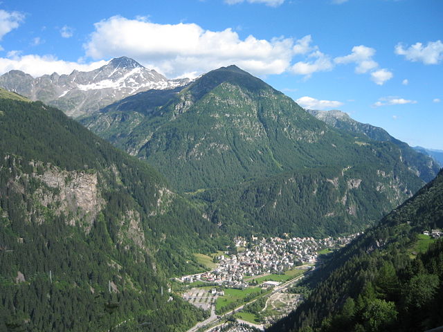
Piuro (Piuro)
.svg)
- Italian comune
 Hiking in Piuro
Piuro is a picturesque village located in the Lombardy region of northern Italy, nestled in the Seriana Valley and close to the border with Switzerland. The area is known for its stunning natural beauty, making it a great destination for hiking enthusiasts. Here are some highlights about hiking in Piuro:
Trails and Terrain
-
Variety of Trails: Piuro offers a range of hiking trails suitable for various skill levels, from easy walks to more challenging hikes. You can explore trails that lead through lush forests, along rivers, and up to panoramic viewpoints.
-
Cascate di Piuro: One of the must-see attractions is the Piuro Waterfalls, a stunning series of cascades that provide a beautiful backdrop for hikes. There are trails that lead to the viewing points of the waterfalls, allowing hikers to appreciate the sound and sight of rushing water.
-
Scenic Views: As you hike, you’ll be treated to breathtaking views of the surrounding mountains, valleys, and vineyards. Some trails offer viewpoints where you can see the entire Seriana Valley.
-
Historical Routes: Many trails in the area are steeped in history, passing by ancient villages, and remnants of old structures. This adds a cultural element to your hiking experience.
Best Time to Hike
- Spring and Fall: The best times for hiking in Piuro are spring (April to June) and fall (September to October) when the weather is mild, and the landscapes are particularly beautiful with blooming flowers in spring and colorful foliage in fall.
- Summer: While summer can also be great for hiking, it might get hot, so early morning or late afternoon hikes are advisable.
Tips for Hikers
- Proper Gear: Wear good hiking boots and dress in layers to adapt to changing weather conditions. A hat and sunscreen are also recommended, especially in the summer months.
- Stay Hydrated: Always carry enough water, particularly on warmer days, and consider bringing snacks for energy.
- Navigation: While many trails are well-marked, carrying a map or using a GPS app can be helpful, especially if you’re venturing off the more popular paths.
Local Amenities
After a long day of hiking, you can enjoy local Italian cuisine in nearby restaurants or cafes. Piuro and the surrounding areas also have accommodations ranging from hotels to bed and breakfasts for those looking to enjoy a longer stay.
Whether you’re looking for a peaceful escape or an adventurous hike, Piuro offers a wonderful opportunity to enjoy the beauty of nature in northern Italy. Make sure to check local maps and guides for the latest trail conditions and options!
- Country:

- Postal Code: 23020
- Local Dialing Code: 0343
- Licence Plate Code: SO
- Coordinates: 46° 19' 51" N, 9° 25' 18" E


- GPS tracks (wikiloc): [Link]
- AboveSeaLevel: 382 м m
- Area: 84.25 sq km
- Population: 1932
- Web site: http://www.piuro.net
- Wikipedia en: wiki(en)
- Wikipedia: wiki(it)
- Wikidata storage: Wikidata: Q39548
- Wikipedia Commons Category: [Link]
- Freebase ID: [/m/0gj3h5]
- GeoNames ID: Alt: [6540281]
- BnF ID: [122367494]
- VIAF ID: Alt: [235649758]
- OSM relation ID: [47093]
- GND ID: Alt: [4368299-6]
- UN/LOCODE: [ITDDI]
- HDS ID: [7071]
- EMLO location ID: [40b9d2bc-76ff-4151-b1ae-d7b3e6de7f6f]
- ISTAT ID: 014050
- Italian cadastre code: G718
Shares border with regions:

Campodolcino
- Italian comune
Hiking in Campodolcino
Campodolcino is a picturesque village located in the province of Sondrio in the Lombardy region of Italy, nestled in the heart of the Italian Alps. This area is not only known for its stunning landscapes but also for the variety of hiking opportunities it offers, catering to all levels of outdoor enthusiasts....
- Country:
- Postal Code: 23021
- Local Dialing Code: 0343
- Licence Plate Code: SO
- Coordinates: 46° 24' 18" N, 9° 21' 11" E
- GPS tracks (wikiloc): [Link]
- AboveSeaLevel: 1071 м m
- Area: 48.49 sq km
- Population: 931
- Web site: [Link]

San Giacomo Filippo
- Italian comune
Hiking in San Giacomo Filippo
San Giacomo Filippo, located in the Sondrio province of Lombardy, Italy, offers a variety of hiking opportunities amidst stunning landscapes of the Valtellina Valley. The region is characterized by its mountainous terrain, charming villages, lush forests, and impressive views of the surrounding Alps....
- Country:
- Postal Code: 23020
- Local Dialing Code: 0343
- Licence Plate Code: SO
- Coordinates: 46° 20' 0" N, 9° 22' 0" E
- GPS tracks (wikiloc): [Link]
- AboveSeaLevel: 679 м m
- Area: 61.85 sq km
- Population: 349
- Web site: [Link]


Villa di Chiavenna
- Italian comune
Hiking in Villa di Chiavenna
Villa di Chiavenna, located in the province of Sondrio in Lombardy, Italy, is a charming destination for hikers and outdoor enthusiasts. Nestled in the heart of the Alps, this area offers stunning landscapes, diverse terrains, and a variety of trails suitable for different skill levels....
- Country:
- Postal Code: 23029
- Local Dialing Code: 0343
- Licence Plate Code: SO
- Coordinates: 46° 20' 0" N, 9° 29' 0" E
- GPS tracks (wikiloc): [Link]
- AboveSeaLevel: 633 м m
- Area: 32.52 sq km
- Population: 990
- Web site: [Link]


Chiavenna
- Italian comune
Hiking in Chiavenna
Chiavenna, located in the Lombardy region of northern Italy, is an excellent destination for hiking due to its stunning natural landscapes and rich cultural history. Nestled at the entrance of the Val Bregaglia and near the borders of Switzerland, this charming town serves as a base for numerous hiking trails that cater to various skill levels....
- Country:
- Postal Code: 23022
- Local Dialing Code: 0343
- Licence Plate Code: SO
- Coordinates: 46° 19' 0" N, 9° 24' 0" E
- GPS tracks (wikiloc): [Link]
- AboveSeaLevel: 333 м m
- Area: 10.77 sq km
- Population: 7313
- Web site: [Link]
Novate Mezzola
- Italian comune
Hiking in Novate Mezzola
Novate Mezzola is a picturesque village located in the province of Sondrio, in the Lombardy region of northern Italy, near the beautiful Lake Mezzola. The surrounding area offers a range of hiking opportunities that cater to various skill levels, all set against the stunning backdrop of the Italian Alps....
- Country:
- Postal Code: 23025
- Local Dialing Code: 0343
- Licence Plate Code: SO
- Coordinates: 46° 13' 0" N, 9° 27' 0" E
- GPS tracks (wikiloc): [Link]
- AboveSeaLevel: 212 м m
- Area: 99.75 sq km
- Population: 1895
- Web site: [Link]


Madesimo
- Italian comune
Hiking in Madesimo
Madesimo, located in the Lombardy region of Italy, is a popular destination for hiking, especially during the summer months when the snow melts and reveals stunning landscapes. Nestled in the Alps, Madesimo offers a variety of trails suitable for hikers of all ages and skill levels. Here are some key highlights of hiking in the area:...
- Country:
- Postal Code: 23024
- Local Dialing Code: 0343
- Licence Plate Code: SO
- Coordinates: 46° 26' 0" N, 9° 21' 0" E
- GPS tracks (wikiloc): [Link]
- AboveSeaLevel: 1399 м m
- Area: 85.66 sq km
- Population: 517
- Web site: [Link]
Prata Camportaccio
- Italian comune
Hiking in Prata Camportaccio
Prata Camportaccio is a picturesque village located in the Valtellina region of northern Italy, surrounded by the stunning landscapes of the Italian Alps. Hiking in this area offers a unique blend of natural beauty, cultural heritage, and a variety of trails suitable for different skill levels....
- Country:
- Postal Code: 23020
- Local Dialing Code: 0343
- Licence Plate Code: SO
- Coordinates: 46° 19' 0" N, 9° 24' 0" E
- GPS tracks (wikiloc): [Link]
- AboveSeaLevel: 352 м m
- Area: 27.94 sq km
- Population: 2950
- Web site: [Link]


Avers
- municipality in the canton of Graubünden, Switzerland
Hiking in Avers
Avers is a beautiful valley located in the Graubünden canton of Switzerland, known for its stunning landscapes, biodiversity, and wide range of hiking opportunities. Here are some highlights and considerations for hiking in the Avers area:...
- Country:

- Postal Code: 7447
- Local Dialing Code: 081
- Licence Plate Code: GR
- Coordinates: 46° 28' 26" N, 9° 30' 49" E
- GPS tracks (wikiloc): [Link]
- AboveSeaLevel: 1960 м m
- Area: 93.12 sq km
- Population: 169
- Web site: [Link]


Ferrera
- municipality in Graubünden, Switzerland
Hiking in Ferrera
Ferrera is a beautiful area in the Italian region of Emilia-Romagna, known for its stunning landscapes, rich history, and diverse hiking trails. While the specific trails and conditions can vary, here’s a general overview of what you can expect when hiking in the Ferrera area:...
- Country:
- Postal Code: 7444
- Local Dialing Code: 081
- Licence Plate Code: GR
- Coordinates: 46° 33' 0" N, 9° 26' 0" E
- GPS tracks (wikiloc): [Link]
- AboveSeaLevel: 1316 м m
- Area: 75.46 sq km
- Population: 76
- Web site: [Link]


Bregaglia
- municipality in Switzerland
Hiking in Bregaglia
Bregaglia, a stunning valley in the southern part of Switzerland, is known for its picturesque landscapes, charming villages, and a wide range of hiking opportunities. Here are some highlights about hiking in the region:...
- Country:
- Postal Code: 7603, 7605, 7606, 7608, 7610, 7516
- Local Dialing Code: 081
- Licence Plate Code: GR
- Coordinates: 46° 20' 0" N, 9° 35' 0" E
- GPS tracks (wikiloc): [Link]
- AboveSeaLevel: 994 м m
- Area: 251.45 sq km
- Population: 1531
- Web site: [Link]