Malmy (Malmy)

- commune in Marne, France
- Country:

- Postal Code: 51800
- Coordinates: 49° 10' 33" N, 4° 48' 40" E


- GPS tracks (wikiloc): [Link]
- Area: 4.83 sq km
- Population: 34
- Wikipedia en: wiki(en)
- Wikipedia: wiki(fr)
- Wikidata storage: Wikidata: Q1115932
- Wikipedia Commons Category: [Link]
- Freebase ID: [/m/03qd7s0]
- GeoNames ID: Alt: [6614258]
- SIREN number: [215103177]
- BnF ID: [152629441]
- INSEE municipality code: 51341
Shares border with regions:


Ville-sur-Tourbe
- commune in Marne, France
- Country:
- Postal Code: 51800
- Coordinates: 49° 11' 12" N, 4° 47' 2" E
- GPS tracks (wikiloc): [Link]
- Area: 11.13 sq km
- Population: 246

Servon-Melzicourt
- commune in Marne, France
- Country:
- Postal Code: 51800
- Coordinates: 49° 12' 54" N, 4° 50' 26" E
- GPS tracks (wikiloc): [Link]
- Area: 25.78 sq km
- Population: 111


Berzieux
- commune in Marne, France
- Country:
- Postal Code: 51800
- Coordinates: 49° 9' 53" N, 4° 47' 50" E
- GPS tracks (wikiloc): [Link]
- Area: 11.67 sq km
- Population: 72

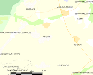
Virginy
- commune in Marne, France
- Country:
- Postal Code: 51800
- Coordinates: 49° 10' 33" N, 4° 45' 37" E
- GPS tracks (wikiloc): [Link]
- Area: 12.28 sq km
- Population: 85