Massello (Massello)

- Italian comune
 Hiking in Massello
Massello is a small village located in the Susa Valley of the Piedmont region in Italy, nestled within the beautiful backdrop of the Alps. It's a fantastic destination for hiking enthusiasts due to its stunning landscapes, diverse trails, and rich natural beauty.
Hiking Trails
-
Sentiero dei Tedeschi: Known as the "Path of the Germans," this historic trail offers breathtaking views and takes hikers through picturesque landscapes. It is well-marked and provides insights into the history of the region.
-
Val di Susa Trails: There are numerous trails in and around the Val di Susa area. Many of these paths lead you through lush forests, past rivers and waterfalls, and up to scenic viewpoints.
-
Alta Via dei Parchi: This high-altitude trail runs through several parks and offers a variety of hiking experiences. Portions of it can be accessed from Massello.
-
Mount Rocciamelone: For more adventurous hikers, a climb to Rocciamelone, one of the tallest peaks in the area, can be a rewarding experience. Be prepared for a strenuous hike that offers stunning panoramic views from the summit.
Preparation and Safety
- Weather: Check local weather conditions before heading out as mountain weather can change rapidly.
- Equipment: Proper hiking gear is essential including sturdy boots, a backpack, water, snacks, a map, and a first aid kit.
- Maps and Trails: Utilize local maps or GPS apps to stay on track. The paths are usually well-marked, but it's always wise to be prepared.
Best Times to Hike
- Late spring to early autumn is typically the best time to hike in Massello. However, early summer and early autumn can offer the most pleasant weather and less crowded trails.
Local Wildlife and Flora
While hiking, you're likely to encounter diverse flora and fauna unique to the alpine environment. Keep an eye out for local birds, deer, and the beautiful wildflowers that bloom in the spring and summer months.
Conclusion
Massello is an excellent base for hiking in the Susa Valley, offering a mix of easy and challenging trails amidst breathtaking alpine scenery. Whether you're a seasoned hiker or a beginner, you'll find something enjoyable in this beautiful region. Just remember to respect nature and leave no trace while exploring!
- Country:

- Postal Code: 10060
- Local Dialing Code: 0121
- Licence Plate Code: TO
- Coordinates: 44° 58' 0" N, 7° 3' 0" E


- GPS tracks (wikiloc): [Link]
- Area: 38.26 sq km
- Population: 52
- Web site: http://www.comune.massello.to.it
- Wikipedia en: wiki(en)
- Wikipedia: wiki(it)
- Wikidata storage: Wikidata: Q9452
- Wikipedia Commons Category: [Link]
- Freebase ID: [/m/0g6x5l]
- GeoNames ID: Alt: [6540132]
- VIAF ID: Alt: [247441976]
- OSM relation ID: [43874]
- ISTAT ID: 001145
- Italian cadastre code: F041
Shares border with regions:


Pragelato
- Italian comune
Hiking in Pragelato
Pragelato, located in the Susa Valley in the Piedmont region of Italy, is a fantastic destination for hiking enthusiasts. Nestled in the Alps, it is known for its stunning landscapes, diverse trails, and opportunities for outdoor activities year-round....
- Country:
- Postal Code: 10060
- Local Dialing Code: 0122
- Licence Plate Code: TO
- Coordinates: 45° 1' 0" N, 6° 57' 0" E
- GPS tracks (wikiloc): [Link]
- AboveSeaLevel: 1518 м m
- Area: 89.2 sq km
- Population: 786
- Web site: [Link]

Roure
- Italian comune
Hiking in Roure
Roure, located in the Piedmont region of Italy, is a charming town nestled in the Susa Valley. The area offers a multitude of hiking opportunities, characterized by stunning landscapes, rich history, and a diverse range of trails suitable for all skill levels....
- Country:
- Postal Code: 10060
- Local Dialing Code: 0121
- Licence Plate Code: TO
- Coordinates: 45° 0' 0" N, 7° 8' 0" E
- GPS tracks (wikiloc): [Link]
- AboveSeaLevel: 750 м m
- Area: 59.37 sq km
- Population: 832
- Web site: [Link]


Salza di Pinerolo
- Italian comune
Hiking in Salza di Pinerolo
Salza di Pinerolo, located in the Piedmont region of Italy, is a fantastic destination for hiking enthusiasts. Situated within the scenic Susa Valley and surrounded by the stunning backdrop of the Alps, this area offers a range of beautiful trails with varying levels of difficulty....
- Country:
- Postal Code: 10060
- Local Dialing Code: 0121
- Licence Plate Code: TO
- Coordinates: 44° 56' 0" N, 7° 3' 0" E
- GPS tracks (wikiloc): [Link]
- AboveSeaLevel: 1245 м m
- Area: 15.89 sq km
- Population: 75
- Web site: [Link]
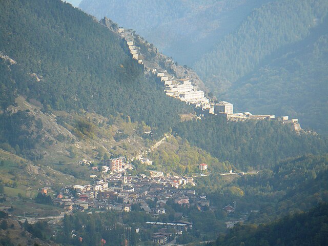

Fenestrelle
- Italian comune
Hiking in Fenestrelle
Fenestrelle, located in the Piedmont region of Italy, is known for its stunning natural beauty and historical significance. The area is particularly famous for the Fort of Fenestrelle, a remarkable fortress that offers a unique backdrop for hiking activities. Here’s an overview of what you can expect when hiking in Fenestrelle:...
- Country:
- Postal Code: 10060
- Local Dialing Code: 0121
- Licence Plate Code: TO
- Coordinates: 45° 2' 0" N, 7° 3' 0" E
- GPS tracks (wikiloc): [Link]
- AboveSeaLevel: 1215 м m
- Area: 49.41 sq km
- Population: 521
- Web site: [Link]


Perrero
- town in Italy
Hiking in Perrero
Perrero is a small town located in the Susa Valley, in the Piedmont region of Italy. It is surrounded by beautiful natural landscapes, making it a great destination for hiking enthusiasts....
- Country:
- Postal Code: 10060
- Local Dialing Code: 0121
- Licence Plate Code: TO
- Coordinates: 44° 56' 0" N, 7° 7' 0" E
- GPS tracks (wikiloc): [Link]
- AboveSeaLevel: 840 м m
- Area: 63.18 sq km
- Population: 665
- Web site: [Link]