Roure (Roure)
- Italian comune
 Hiking in Roure
Roure, located in the Piedmont region of Italy, is a charming town nestled in the Susa Valley. The area offers a multitude of hiking opportunities, characterized by stunning landscapes, rich history, and a diverse range of trails suitable for all skill levels.
Hiking Highlights in Roure:
-
Scenic Trails: The surrounding mountains, including the Cozie Alps, provide numerous trails that allow hikers to experience breathtaking views of valleys, forests, and alpine meadows. Look for trails that lead to panoramic viewpoints or historical sites.
-
Variety of Terrains: The hiking routes in the area can vary from easy walks to more challenging scrambles. You might encounter gentle slopes, rocky paths, and even higher altitude trails that require a bit more fitness and preparation.
-
Natural Beauty: The region is known for its rich biodiversity, including lush vegetation and opportunities to spot wildlife. Be sure to bring your camera, as the landscapes can be quite picturesque, especially in spring and fall.
-
Cultural Heritage: Many hiking trails pass by ancient churches, old ruins, and charming villages, allowing you to immerse yourself in the local culture and history along the way.
-
Trail Recommendations:
- Path of the Ridges (Sentiero dei Crinali): A longer trek that offers views of the entire valley.
- Licano Mountain Trail: A more challenging route suitable for experienced hikers, known for its steep ascents and rewarding vistas.
Practical Tips:
- Best Time to Hike: Spring (April to June) and early fall (September to October) are ideal for hiking, as the weather is typically mild and the landscapes are vibrant.
- Gear: Ensure you have proper hiking boots, a map, and sufficient water and snacks. Some trails may require more technical gear, especially those that are steep or rocky.
- Local Resources: Check with local hiking clubs or tourist information centers for trail maps, guided tours, and the latest trail conditions.
Safety Considerations:
- Weather Conditions: The weather can change rapidly in the mountains, so always check forecasts before heading out.
- Staying on Trails: To protect the environment and for your safety, stick to marked paths to avoid getting lost or damaging local flora.
Hiking in Roure can be a rewarding experience for both nature lovers and adventure seekers. Enjoy your trek!
- Country:

- Postal Code: 10060
- Local Dialing Code: 0121
- Licence Plate Code: TO
- Coordinates: 45° 0' 0" N, 7° 8' 0" E


- GPS tracks (wikiloc): [Link]
- AboveSeaLevel: 750 м m
- Area: 59.37 sq km
- Population: 832
- Web site: http://www.comune.roure.to.it/
- Wikipedia en: wiki(en)
- Wikipedia: wiki(it)
- Wikidata storage: Wikidata: Q10245
- Wikipedia Commons Category: [Link]
- Freebase ID: [/m/0g8l6p]
- GeoNames ID: Alt: [6542388]
- OSM relation ID: [43916]
- UN/LOCODE: [ITRRE]
- ISTAT ID: 001227
- Italian cadastre code: H555
Shares border with regions:


San Giorio di Susa
- Italian comune
Hiking in San Giorio di Susa
San Giorio di Susa is a charming village located in the Susa Valley of the Piedmont region in northern Italy. Nestled in the foothills of the Alps, it offers a variety of hiking opportunities that cater to different skill levels and preferences....
- Country:
- Postal Code: 10050
- Local Dialing Code: 0122
- Licence Plate Code: TO
- Coordinates: 45° 8' 0" N, 7° 10' 0" E
- GPS tracks (wikiloc): [Link]
- Area: 19.74 sq km
- Population: 996
- Web site: [Link]


Bussoleno
- Italian comune
Hiking in Bussoleno
Bussoleno is a charming town located in the Susa Valley in the Piedmont region of Italy, nestled in the foothills of the Alps. It offers a variety of hiking opportunities, making it an appealing destination for outdoor enthusiasts. Here are some highlights and tips for hiking in Bussoleno:...
- Country:
- Postal Code: 10053
- Local Dialing Code: 0122
- Licence Plate Code: TO
- Coordinates: 45° 8' 28" N, 7° 8' 51" E
- GPS tracks (wikiloc): [Link]
- AboveSeaLevel: 440 м m
- Area: 37.07 sq km
- Population: 5981
- Web site: [Link]


Coazze
- Italian comune
Hiking in Coazze
Coazze, a charming village located in the Susa Valley in the Piedmont region of Italy, offers a variety of hiking opportunities that cater to all levels of experience. The surrounding landscape features lush forests, stunning mountain views, and picturesque trails, making it a great destination for outdoor enthusiasts....
- Country:
- Postal Code: 10050
- Local Dialing Code: 011
- Licence Plate Code: TO
- Coordinates: 45° 3' 7" N, 7° 18' 2" E
- GPS tracks (wikiloc): [Link]
- AboveSeaLevel: 750 м m
- Area: 56.57 sq km
- Population: 3203
- Web site: [Link]
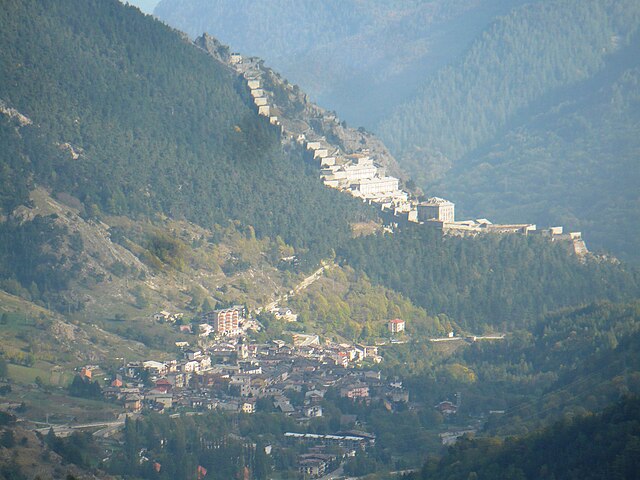

Fenestrelle
- Italian comune
Hiking in Fenestrelle
Fenestrelle, located in the Piedmont region of Italy, is known for its stunning natural beauty and historical significance. The area is particularly famous for the Fort of Fenestrelle, a remarkable fortress that offers a unique backdrop for hiking activities. Here’s an overview of what you can expect when hiking in Fenestrelle:...
- Country:
- Postal Code: 10060
- Local Dialing Code: 0121
- Licence Plate Code: TO
- Coordinates: 45° 2' 0" N, 7° 3' 0" E
- GPS tracks (wikiloc): [Link]
- AboveSeaLevel: 1215 м m
- Area: 49.41 sq km
- Population: 521
- Web site: [Link]


Massello
- Italian comune
Hiking in Massello
Massello is a small village located in the Susa Valley of the Piedmont region in Italy, nestled within the beautiful backdrop of the Alps. It's a fantastic destination for hiking enthusiasts due to its stunning landscapes, diverse trails, and rich natural beauty....
- Country:
- Postal Code: 10060
- Local Dialing Code: 0121
- Licence Plate Code: TO
- Coordinates: 44° 58' 0" N, 7° 3' 0" E
- GPS tracks (wikiloc): [Link]
- Area: 38.26 sq km
- Population: 52
- Web site: [Link]
Mattie
- Italian comune
Hiking in Mattie
Hiking in Mattie, Piedmont, offers a beautiful blend of scenic views and the tranquility of nature. The region is known for its stunning landscapes, including rolling hills, dense forests, and potentially some water bodies like rivers or lakes, depending on the exact area....
- Country:
- Postal Code: 10050
- Local Dialing Code: 0122
- Licence Plate Code: TO
- Coordinates: 45° 7' 0" N, 7° 7' 0" E
- GPS tracks (wikiloc): [Link]
- AboveSeaLevel: 730 м m
- Area: 28.69 sq km
- Population: 662
- Web site: [Link]


Perosa Argentina
- Italian comune
Hiking in Perosa Argentina
Perosa Argentina is a picturesque village located in the Susa Valley of the Piedmont region in Italy. While it may not be as widely known as some other hiking destinations, it offers beautiful landscapes and outdoor activities....
- Country:
- Postal Code: 10063
- Local Dialing Code: 0121
- Licence Plate Code: TO
- Coordinates: 44° 57' 0" N, 7° 12' 0" E
- GPS tracks (wikiloc): [Link]
- AboveSeaLevel: 630 м m
- Area: 26.09 sq km
- Population: 3209
- Web site: [Link]


Perrero
- town in Italy
Hiking in Perrero
Perrero is a small town located in the Susa Valley, in the Piedmont region of Italy. It is surrounded by beautiful natural landscapes, making it a great destination for hiking enthusiasts....
- Country:
- Postal Code: 10060
- Local Dialing Code: 0121
- Licence Plate Code: TO
- Coordinates: 44° 56' 0" N, 7° 7' 0" E
- GPS tracks (wikiloc): [Link]
- AboveSeaLevel: 840 м m
- Area: 63.18 sq km
- Population: 665
- Web site: [Link]