Maumusson-Laguian (Maumusson-Laguian)

- commune in Gers, France
- Country:

- Postal Code: 32400
- Coordinates: 43° 36' 31" N, 0° 6' 7" E


- GPS tracks (wikiloc): [Link]
- Area: 9.3 sq km
- Population: 138
- Wikipedia en: wiki(en)
- Wikipedia: wiki(fr)
- Wikidata storage: Wikidata: Q1341105
- Wikipedia Commons Category: [Link]
- Freebase ID: [/m/03nrr2c]
- GeoNames ID: Alt: [6432001]
- SIREN number: [213202450]
- BnF ID: [15255831x]
- INSEE municipality code: 32245
Shares border with regions:

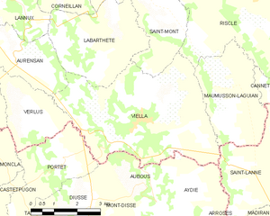
Viella
- commune in Gers, France
- Country:
- Postal Code: 32400
- Coordinates: 43° 35' 55" N, 0° 8' 24" E
- GPS tracks (wikiloc): [Link]
- AboveSeaLevel: 241 м m
- Area: 22.02 sq km
- Population: 529


Saint-Lanne
- commune in Hautes-Pyrénées, France
- Country:
- Postal Code: 65700
- Coordinates: 43° 35' 35" N, 0° 3' 41" E
- GPS tracks (wikiloc): [Link]
- Area: 13.1 sq km
- Population: 135

Riscle
- commune in Gers, France
- Country:
- Postal Code: 32400
- Coordinates: 43° 39' 24" N, 0° 5' 14" E
- GPS tracks (wikiloc): [Link]
- Area: 31.74 sq km
- Population: 1719


Cannet
- commune in Gers, France
- Country:
- Postal Code: 32400
- Coordinates: 43° 36' 45" N, 0° 3' 15" E
- GPS tracks (wikiloc): [Link]
- Area: 4.81 sq km
- Population: 55