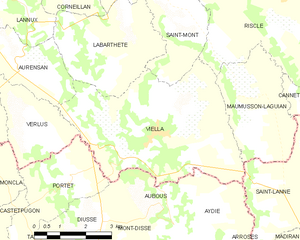
canton of Riscle (canton de Riscle)
- canton of France
- Country:

- Capital: Riscle
- Coordinates: 43° 39' 29" N, 0° 10' 2" E


- GPS tracks (wikiloc): [Link]
- Wikidata storage: Wikidata: Q1726962
- INSEE canton code: [3224]
Includes regions:

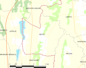
Ségos
- commune in Gers, France
- Country:
- Postal Code: 32400
- Coordinates: 43° 37' 30" N, 0° 15' 25" E
- GPS tracks (wikiloc): [Link]
- Area: 8.67 sq km
- Population: 238
Vergoignan
- commune in Gers, France
- Country:
- Postal Code: 32720
- Coordinates: 43° 43' 4" N, 0° 11' 54" E
- GPS tracks (wikiloc): [Link]
- Area: 10.44 sq km
- Population: 283

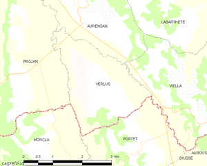
Verlus
- commune in Gers, France
- Country:
- Postal Code: 32400
- Coordinates: 43° 36' 8" N, 0° 11' 48" E
- GPS tracks (wikiloc): [Link]
- Area: 6.19 sq km
- Population: 93

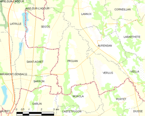
Projan
- commune in Gers, France
- Country:
- Postal Code: 32400
- Coordinates: 43° 35' 58" N, 0° 14' 14" E
- GPS tracks (wikiloc): [Link]
- Area: 11.78 sq km
- Population: 177


Maulichères
- commune in Gers, France
- Country:
- Postal Code: 32400
- Coordinates: 43° 41' 21" N, 0° 5' 25" E
- GPS tracks (wikiloc): [Link]
- Area: 6.18 sq km
- Population: 171

Lannux
- commune in Gers, France
- Country:
- Postal Code: 32400
- Coordinates: 43° 38' 50" N, 0° 13' 1" E
- GPS tracks (wikiloc): [Link]
- Area: 12.83 sq km
- Population: 244


Labarthète
- commune in Gers, France
- Country:
- Postal Code: 32400
- Coordinates: 43° 37' 46" N, 0° 9' 23" E
- GPS tracks (wikiloc): [Link]
- Area: 11.09 sq km
- Population: 141

Viella
- commune in Gers, France
- Country:
- Postal Code: 32400
- Coordinates: 43° 35' 55" N, 0° 8' 24" E
- GPS tracks (wikiloc): [Link]
- AboveSeaLevel: 241 м m
- Area: 22.02 sq km
- Population: 529
Arblade-le-Bas
- commune in Gers, France
- Country:
- Postal Code: 32720
- Coordinates: 43° 42' 26" N, 0° 10' 37" E
- GPS tracks (wikiloc): [Link]
- Area: 7.67 sq km
- Population: 153


Maumusson-Laguian
- commune in Gers, France
- Country:
- Postal Code: 32400
- Coordinates: 43° 36' 31" N, 0° 6' 7" E
- GPS tracks (wikiloc): [Link]
- Area: 9.3 sq km
- Population: 138


Lelin-Lapujolle
- commune in Gers, France
- Country:
- Postal Code: 32400
- Coordinates: 43° 42' 24" N, 0° 8' 47" E
- GPS tracks (wikiloc): [Link]
- AboveSeaLevel: 142.0 м m
- Area: 13.56 sq km
- Population: 267


Bernède
- commune in Gers, France
- Country:
- Postal Code: 32400
- Coordinates: 43° 40' 10" N, 0° 13' 18" E
- GPS tracks (wikiloc): [Link]
- Area: 8.18 sq km
- Population: 206


Caumont
- commune in Gers, France
- Country:
- Postal Code: 32400
- Coordinates: 43° 41' 29" N, 0° 6' 15" E
- GPS tracks (wikiloc): [Link]
- AboveSeaLevel: 181 м m
- Area: 7.15 sq km
- Population: 107


Aurensan
- commune in Gers, France
- Country:
- Postal Code: 32400
- Coordinates: 43° 37' 5" N, 0° 12' 13" E
- GPS tracks (wikiloc): [Link]
- AboveSeaLevel: 170 м m
- Area: 6.33 sq km
- Population: 135