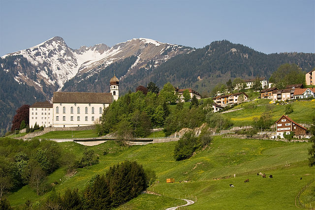
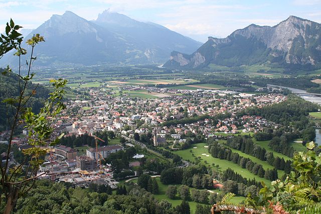
Mels (Mels)

- municipality in Switzerland
 Hiking in Mels
Mels is a picturesque village located in the canton of St. Gallen in Switzerland, surrounded by beautiful landscapes and accessible hiking trails. The area offers a variety of hiking routes suitable for different skill levels, from leisurely strolls to more challenging treks. Here are some highlights for hiking in Mels:
Scenic Trails
-
Mels to the Churfirsten: This trail offers stunning views of the Churfirsten mountain range. The hike can be moderately challenging but rewards with panoramic vistas.
-
Wildschlucht (Wild Gorge): A shorter but beautiful hike that takes you through the lush gorge with opportunities to see local wildlife and impressive rock formations.
-
Pizol Mountain: Although slightly further away, the trails leading from Mels to Pizol are popular. The Pizol area offers various hiking paths, including scenic routes with views of the Pizolsee and the surrounding alps.
Family-friendly Options
- Leisurely paths around Mels: There are several gentle walking paths that are suitable for families and beginners, where you can enjoy the local flora and fauna.
Essentials to Consider
-
Season: Spring to autumn is ideal for hiking, as trails are usually in good condition. Winter hikes can also be done but may require specific gear.
-
Preparation: Make sure to dress in layers, wear good hiking shoes, and bring sufficient water and snacks. Always check trail conditions and weather forecasts before heading out.
-
Local Guides: Consider joining guided hikes if you’d like to learn more about the region’s plants, animals, and history while exploring.
Transportation
Mels is easily accessible by public transport, including trains and buses, making it convenient to reach various trailheads starting from the village.
Conclusion
Whether you’re looking for a day hike or planning a more extended trekking adventure, Mels provides a great base for exploring the nature and beauty of this serene region in Switzerland. Happy hiking!
- Country:

- Postal Code: 8887
- Local Dialing Code: 081
- Licence Plate Code: SG
- Coordinates: 47° 2' 59" N, 9° 25' 0" E


- GPS tracks (wikiloc): [Link]
- AboveSeaLevel: 1579 м m
- Area: 140.00 sq km
- Population: 8610
- Web site: http://www.mels.ch
- Wikipedia en: wiki(en)
- Wikipedia: wiki(de)
- Wikidata storage: Wikidata: Q67027
- Wikipedia Commons Category: [Link]
- Freebase ID: [/m/0gnryx]
- GeoNames ID: Alt: [7286481]
- VIAF ID: Alt: [157286936]
- OSM relation ID: [1683906]
- archINFORM location ID: [11252]
- HDS ID: [1354]
- Swiss municipality code: [3293]
- Digital Atlas of the Roman Empire ID: [42779]
Shares border with regions:


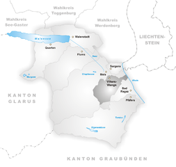
Sargans
- municipality in Switzerland
Hiking in Sargans
Sargans, located in the eastern part of Switzerland, offers a variety of beautiful hiking trails suitable for different skill levels, making it a great destination for outdoor enthusiasts. Nestled in the foothills of the Alps, Sargans provides stunning views of the surrounding mountains and valleys....
- Country:
- Postal Code: 7320
- Local Dialing Code: 081
- Licence Plate Code: SG
- Coordinates: 47° 2' 53" N, 9° 26' 23" E
- GPS tracks (wikiloc): [Link]
- AboveSeaLevel: 483 м m
- Area: 9.48 sq km
- Population: 6118
- Web site: [Link]


Fläsch
- municipality in the district of Landquart in the Swiss canton of Graubünden
Hiking in Fläsch
Fläsch is a charming village located in the Bündner Herrschaft region of Switzerland, known for its stunning natural landscapes and excellent hiking opportunities. The area around Fläsch features a mix of vineyards, forests, and panoramic mountain views, making it an ideal destination for both casual walkers and experienced hikers....
- Country:
- Postal Code: 7306
- Local Dialing Code: 081
- Licence Plate Code: GR
- Coordinates: 47° 2' 23" N, 9° 31' 59" E
- GPS tracks (wikiloc): [Link]
- AboveSeaLevel: 528 м m
- Area: 19.94 sq km
- Population: 774
- Web site: [Link]

Pfäfers
- municipality in Switzerland
Hiking in Pfäfers
Pfäfers, located in the canton of St. Gallen in Switzerland, is a stunning destination for hiking enthusiasts. The region is renowned for its dramatic landscapes, featuring the picturesque Rhine Gorge, often referred to as the "Grand Canyon of Switzerland." Here are some highlights and tips for hiking in Pfäfers:...
- Country:
- Postal Code: 7312
- Local Dialing Code: 081
- Licence Plate Code: SG
- Coordinates: 46° 58' 59" N, 9° 29' 59" E
- GPS tracks (wikiloc): [Link]
- AboveSeaLevel: 820 м m
- Area: 128.53 sq km
- Population: 1574
- Web site: [Link]

Vilters-Wangs
- municipality in Switzerland
Hiking in Vilters-Wangs
Vilters-Wangs is a beautiful municipality located in the canton of St. Gallen in Switzerland, offering stunning alpine scenery and a range of hiking opportunities. The region is characterized by its picturesque landscapes, lush valleys, and breathtaking mountain views, making it a great destination for hiking enthusiasts of all levels....
- Country:
- Postal Code: 7323
- Local Dialing Code: 081
- Licence Plate Code: SG
- Coordinates: 47° 1' 0" N, 9° 27' 0" E
- GPS tracks (wikiloc): [Link]
- AboveSeaLevel: 499 м m
- Area: 32.70 sq km
- Population: 4820
- Web site: [Link]


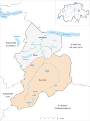
Wartau
- municipality in Switzerland
Hiking in Wartau
Wartau, located in the canton of St. Gallen in Switzerland, is a beautiful destination for hiking enthusiasts. The region boasts stunning landscapes, including rolling hills, picturesque valleys, and views of the Swiss Alps....
- Country:
- Postal Code: 9478
- Local Dialing Code: 081
- Licence Plate Code: SG
- Coordinates: 47° 4' 59" N, 9° 29' 0" E
- GPS tracks (wikiloc): [Link]
- AboveSeaLevel: 472 м m
- Area: 41.74 sq km
- Population: 5296
- Web site: [Link]

Flums
- municipality in Switzerland
Hiking in Flums
Flums is a picturesque village located in the Swiss canton of St. Gallen, surrounded by stunning landscapes and mountainous terrain, making it a fantastic destination for hikers of all levels. Here’s a brief overview of what you can expect when hiking in Flums:...
- Country:
- Postal Code: 8890
- Local Dialing Code: 081
- Licence Plate Code: SG
- Coordinates: 47° 5' 34" N, 9° 20' 38" E
- GPS tracks (wikiloc): [Link]
- AboveSeaLevel: 1124 м m
- Area: 75.03 sq km
- Population: 4941
- Web site: [Link]

Glarus Süd
- municipality in Switzerland
Hiking in Glarus Süd
Glarus Süd, located in the canton of Glarus in Switzerland, is a fantastic destination for hiking enthusiasts. This region boasts stunning landscapes, ranging from lush valleys to rugged mountain terrains. Here are some key points about hiking in Glarus Süd:...
- Country:
- Postal Code: 8756, 8762, 8765, 8766, 8767, 8772, 8773, 8774, 8775, 8777, 8782, 8783, 8784
- Local Dialing Code: 055
- Licence Plate Code: GL
- Coordinates: 46° 59' 40" N, 9° 4' 27" E
- GPS tracks (wikiloc): [Link]
- AboveSeaLevel: 521 м m
- Area: 430.2 sq km
- Population: 9581
- Web site: [Link]

Bad Ragaz
- municipality in Switzerland
Hiking in Bad Ragaz
Bad Ragaz, located in the Swiss Rhine Valley near the foothills of the Alps, is a fantastic destination for hiking enthusiasts. Known for its thermal baths and wellness resorts, the area also offers beautiful landscapes and a variety of hiking trails suitable for different skill levels. Here are some highlights for hiking in Bad Ragaz:...
- Country:
- Postal Code: 7310
- Local Dialing Code: 081
- Licence Plate Code: SG
- Coordinates: 46° 59' 59" N, 9° 30' 0" E
- GPS tracks (wikiloc): [Link]
- AboveSeaLevel: 516 м m
- Area: 25.37 sq km
- Population: 5923
- Web site: [Link]