Monte Giberto (Monte Giberto)
.svg)
- Italian comune
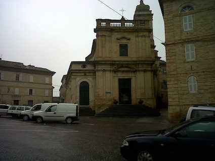
 Hiking in Monte Giberto
Monte Giberto is a beautiful location in the Marche region of Italy, known for its picturesque landscapes and charming hilltop villages. While it may not be as famous as some other hiking destinations, it offers a great opportunity for outdoor enthusiasts and those looking to explore the natural beauty of Central Italy.
Hiking Trails
There are several hiking trails around Monte Giberto that cater to various skill levels. Some of the main features include:
-
Scenic Views: The trails often lead to viewpoints that offer stunning panoramas of the surrounding hills, valleys, and the Adriatic Sea on clear days.
-
Natural Beauty: The area is characterized by lush greenery, vineyards, and olive groves, making hikes visually appealing, especially in spring and fall.
-
Cultural Landmarks: Along the trails, you might discover small chapels and ancient ruins, adding a cultural dimension to your hike.
Tips for Hiking in Monte Giberto
-
Check the Weather: Weather in the Marche region can change quickly, so be sure to check the forecast and prepare accordingly.
-
Wear Appropriate Footwear: Good hiking shoes are essential for navigating the sometimes uneven terrain.
-
Stay Hydrated: Bring plenty of water, especially if you are planning a longer hike.
-
Map and Trails: Familiarize yourself with the trails in the area. Some local maps or tourist guides can be very helpful for navigation.
-
Respect Nature: Follow the Leave No Trace principles to preserve the natural beauty of the area.
-
Local Resources: Consider reaching out to local hiking clubs or guides for the best route recommendations and to learn more about the history and ecology of the area.
Local Attractions
After your hike, you may want to explore nearby towns such as:
- Fermo: Known for its medieval architecture and beautiful countryside.
- Amandola: A charming town with access to the Sibillini Mountains National Park.
- Ascoli Piceno: Famous for its stunning piazzas and historic buildings.
Whether you are looking for a half-day hike or a longer trek, Monte Giberto and its surroundings offer a peaceful escape into nature with the added benefit of rich cultural experiences. Enjoy your outdoor adventure!
- Country:

- Postal Code: 63846
- Local Dialing Code: 0734
- Licence Plate Code: FM
- Coordinates: 43° 5' 29" N, 13° 37' 51" E


- GPS tracks (wikiloc): [Link]
- AboveSeaLevel: 323 м m
- Area: 12.53 sq km
- Population: 785
- Web site: http://www.montegiberto.com
- Wikipedia en: wiki(en)
- Wikipedia: wiki(it)
- Wikidata storage: Wikidata: Q59241
- Wikipedia Commons Category: [Link]
- Freebase ID: [/m/0gl88p]
- GeoNames ID: Alt: [6540462]
- VIAF ID: Alt: [236157907]
- OSM relation ID: [42314]
- Google Maps Customer ID: [290531176775783760]
- ISTAT ID: 109016
- Italian cadastre code: F517
Shares border with regions:

Grottazzolina
- Italian comune
Hiking in Grottazzolina
Grottazzolina is a charming town located in the Marche region of Italy, known for its beautiful landscapes and natural scenery, making it a great destination for hiking enthusiasts. The area offers various trails that can cater to different levels of hikers. Here are some highlights about hiking in and around Grottazzolina:...
- Country:
- Postal Code: 63844
- Local Dialing Code: 0734
- Licence Plate Code: FM
- Coordinates: 43° 6' 40" N, 13° 36' 3" E
- GPS tracks (wikiloc): [Link]
- AboveSeaLevel: 227 м m
- Area: 9.26 sq km
- Population: 3333
- Web site: [Link]


Monte Vidon Combatte
- Italian comune
Hiking in Monte Vidon Combatte
Monte Vidon Combatte is a picturesque area located in the Marche region of Italy, offering a delightful mix of natural beauty, cultural heritage, and outdoor recreation opportunities. Here are some key points to consider for hiking in this area:...
- Country:
- Postal Code: 63847
- Local Dialing Code: 0734
- Licence Plate Code: FM
- Coordinates: 43° 2' 59" N, 13° 37' 49" E
- GPS tracks (wikiloc): [Link]
- AboveSeaLevel: 393 м m
- Area: 11.17 sq km
- Population: 434
- Web site: [Link]

Montottone
- Italian comune
Hiking in Montottone
Montottone is a charming hilltop village located in the Marche region of Italy. Known for its picturesque landscapes, rich history, and beautiful architecture, it offers a variety of hiking opportunities for outdoor enthusiasts. Here are some aspects to consider if you're planning to hike in and around Montottone:...
- Country:
- Postal Code: 63843
- Local Dialing Code: 0734
- Licence Plate Code: FM
- Coordinates: 43° 3' 43" N, 13° 35' 5" E
- GPS tracks (wikiloc): [Link]
- AboveSeaLevel: 277 м m
- Area: 16.38 sq km
- Population: 978
- Web site: [Link]


Petritoli
- Italian comune
Hiking in Petritoli
Petritoli is a charming small town located in the Marche region of Italy, known for its scenic landscapes and historical architecture. Its position on a hill offers stunning views of the surrounding countryside, making it an ideal base for hiking enthusiasts. Here are some key points about hiking in and around Petritoli:...
- Country:
- Postal Code: 63848
- Local Dialing Code: 0734
- Licence Plate Code: FM
- Coordinates: 43° 4' 2" N, 13° 39' 22" E
- GPS tracks (wikiloc): [Link]
- AboveSeaLevel: 358 м m
- Area: 24 sq km
- Population: 2297
- Web site: [Link]
Ponzano di Fermo
- Italian comune
Hiking in Ponzano di Fermo
Ponzano di Fermo is a charming village located in the Marche region of Italy, surrounded by beautiful landscapes ideal for hiking enthusiasts. The area offers various trails that allow hikers to explore the stunning natural beauty, historical sites, and local culture....
- Country:
- Postal Code: 63845
- Local Dialing Code: 0734
- Licence Plate Code: FM
- Coordinates: 43° 6' 6" N, 13° 39' 30" E
- GPS tracks (wikiloc): [Link]
- AboveSeaLevel: 248 м m
- Area: 14.27 sq km
- Population: 1652
- Web site: [Link]