Petritoli (Petritoli)
.svg)
- Italian comune
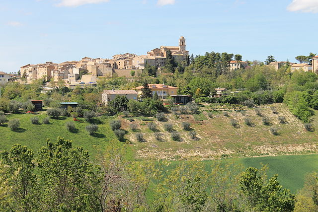
 Hiking in Petritoli
Petritoli is a charming small town located in the Marche region of Italy, known for its scenic landscapes and historical architecture. Its position on a hill offers stunning views of the surrounding countryside, making it an ideal base for hiking enthusiasts. Here are some key points about hiking in and around Petritoli:
Trails and Landscapes
-
Varied Terrain: The area around Petritoli features a mix of rolling hills, vineyards, olive groves, and woodlands, offering a variety of hiking experiences. The diverse terrain makes it suitable for both beginners and more experienced hikers.
-
Nature Reserves: Nearby natural reserves, such as the Sibillini Mountains National Park, provide opportunities for more challenging hikes with breathtaking views, diverse wildlife, and rich flora.
-
Local Routes: There are numerous local trails that can be explored directly from Petritoli. These paths often connect to neighboring villages, allowing hikers to enjoy the local culture, architecture, and cuisine along the way.
Points of Interest
-
Historic Sites: As you hike around Petritoli, you might encounter historical landmarks and churches. Stop to appreciate the architecture and learn about the town’s history.
-
Local Culture: The Marche region is known for its culinary delights. After a day of hiking, you can savor local specialties in town, which can enhance your overall experience.
Tips for Hiking in Petritoli
-
Prepare for Varying Weather: The weather can change quickly, so be prepared with appropriate clothing and gear, including layers, waterproof jackets, and sturdy footwear.
-
Stay Hydrated and Energized: Carry sufficient water and snacks, especially if you plan on hiking longer trails.
-
Maps and Navigation: While some trails may be well-marked, it’s a good idea to carry a map or download hiking apps that work offline for safe navigation.
-
Respect Nature: Stay on designated paths to protect the local ecosystem, and practice leave-no-trace principles to preserve the beauty of the area.
-
Timing: Spring and early fall are great times for hiking in this region, as you can enjoy mild temperatures and avoid the summer heat.
If you plan to hike in Petritoli, consider spending some time exploring the charming town itself, enjoying the views, and perhaps even participating in local events or festivals which may enhance your visit. Happy hiking!
- Country:

- Postal Code: 63848
- Local Dialing Code: 0734
- Licence Plate Code: FM
- Coordinates: 43° 4' 2" N, 13° 39' 22" E


- GPS tracks (wikiloc): [Link]
- AboveSeaLevel: 358 м m
- Area: 24 sq km
- Population: 2297
- Web site: http://www.comune.petritoli.fm.it/
- Wikipedia en: wiki(en)
- Wikipedia: wiki(it)
- Wikidata storage: Wikidata: Q59282
- Wikipedia Commons Category: [Link]
- Freebase ID: [/m/0gl8r0]
- GeoNames ID: Alt: [6541076]
- VIAF ID: Alt: [245857235]
- OSM relation ID: [42300]
- WOEID: [720245]
- UN/LOCODE: [ITPRI]
- Google Maps Customer ID: [17271585960487905998]
- ISTAT ID: 109031
- Italian cadastre code: G516
Shares border with regions:


Carassai
- Italian comune
Hiking in Carassai
Carassai, located in the Marche region of Italy, offers a unique hiking experience with its beautiful landscapes, rolling hills, and cultural heritage. While the town itself is relatively small, the surrounding area provides various trails that can cater to different skill levels....
- Country:
- Postal Code: 63063
- Local Dialing Code: 0734
- Licence Plate Code: AP
- Coordinates: 43° 1' 56" N, 13° 41' 1" E
- GPS tracks (wikiloc): [Link]
- AboveSeaLevel: 365 м m
- Area: 22.24 sq km
- Population: 1055
- Web site: [Link]


Montefiore dell'Aso
- Italian comune
Hiking in Montefiore dell'Aso
Montefiore dell'Aso is a charming hilltop village located in the Marche region of Italy, known for its beautiful landscapes, historical architecture, and a rich cultural heritage. Hiking in and around Montefiore dell'Aso offers a unique blend of natural beauty and cultural exploration....
- Country:
- Postal Code: 63062
- Local Dialing Code: 0734
- Licence Plate Code: AP
- Coordinates: 43° 3' 6" N, 13° 45' 5" E
- GPS tracks (wikiloc): [Link]
- AboveSeaLevel: 412 м m
- Area: 28.21 sq km
- Population: 2053
- Web site: [Link]

Monte Giberto
- Italian comune
Hiking in Monte Giberto
Monte Giberto is a beautiful location in the Marche region of Italy, known for its picturesque landscapes and charming hilltop villages. While it may not be as famous as some other hiking destinations, it offers a great opportunity for outdoor enthusiasts and those looking to explore the natural beauty of Central Italy....
- Country:
- Postal Code: 63846
- Local Dialing Code: 0734
- Licence Plate Code: FM
- Coordinates: 43° 5' 29" N, 13° 37' 51" E
- GPS tracks (wikiloc): [Link]
- AboveSeaLevel: 323 м m
- Area: 12.53 sq km
- Population: 785
- Web site: [Link]


Monterubbiano
- Italian comune
Hiking in Monterubbiano
Monterubbiano is a charming hilltop town located in the Marche region of Italy, known for its scenic views, medieval architecture, and rich cultural heritage. Hiking around Monterubbiano offers opportunities to explore beautiful landscapes, quaint countryside, and historical sites....
- Country:
- Postal Code: 63825
- Local Dialing Code: 0734
- Licence Plate Code: FM
- Coordinates: 43° 5' 7" N, 13° 43' 0" E
- GPS tracks (wikiloc): [Link]
- AboveSeaLevel: 463 м m
- Area: 32.24 sq km
- Population: 2164
- Web site: [Link]


Monte Vidon Combatte
- Italian comune
Hiking in Monte Vidon Combatte
Monte Vidon Combatte is a picturesque area located in the Marche region of Italy, offering a delightful mix of natural beauty, cultural heritage, and outdoor recreation opportunities. Here are some key points to consider for hiking in this area:...
- Country:
- Postal Code: 63847
- Local Dialing Code: 0734
- Licence Plate Code: FM
- Coordinates: 43° 2' 59" N, 13° 37' 49" E
- GPS tracks (wikiloc): [Link]
- AboveSeaLevel: 393 м m
- Area: 11.17 sq km
- Population: 434
- Web site: [Link]
Ponzano di Fermo
- Italian comune
Hiking in Ponzano di Fermo
Ponzano di Fermo is a charming village located in the Marche region of Italy, surrounded by beautiful landscapes ideal for hiking enthusiasts. The area offers various trails that allow hikers to explore the stunning natural beauty, historical sites, and local culture....
- Country:
- Postal Code: 63845
- Local Dialing Code: 0734
- Licence Plate Code: FM
- Coordinates: 43° 6' 6" N, 13° 39' 30" E
- GPS tracks (wikiloc): [Link]
- AboveSeaLevel: 248 м m
- Area: 14.27 sq km
- Population: 1652
- Web site: [Link]