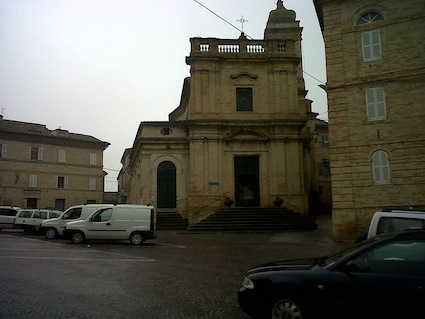
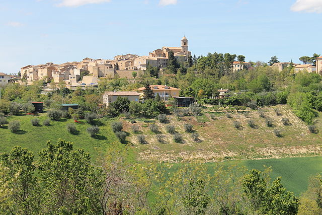
Ponzano di Fermo (Ponzano di Fermo)
.svg)
- Italian comune
 Hiking in Ponzano di Fermo
Ponzano di Fermo is a charming village located in the Marche region of Italy, surrounded by beautiful landscapes ideal for hiking enthusiasts. The area offers various trails that allow hikers to explore the stunning natural beauty, historical sites, and local culture.
Hiking Trails
-
Nature Trails: Various trails wind through the surrounding hills and countryside. These paths range in difficulty and can lead you through olive groves, vineyards, and forests, providing breathtaking views of the Aso Valley and the nearby Sibillini Mountains.
-
Historical Routes: Ponzano di Fermo is rich in history. Some trails may lead to nearby historical sites, such as old churches and ruins, allowing you to combine hiking with a bit of cultural exploration.
-
Local Parks: There are several natural parks and reserves in the region that feature marked trails. These parks often host diverse flora and fauna, making for an excellent opportunity for nature observation.
Preparation Tips
- Season: The best time to hike in this region is during spring (April to June) and early autumn (September to October) when the weather is mild and pleasant.
- Gear: Make sure to wear sturdy hiking boots and bring sufficient water, snacks, and sun protection.
- Maps: It’s helpful to have a local map or a hiking app that provides detailed trail information, as not all paths may be well-marked.
Local Attractions
- Don’t miss the opportunity to enjoy local cuisine in Ponzano di Fermo after your hike, with many restaurants serving traditional Marche dishes.
- Explore nearby towns, such as Fermo and Servigliano, which offer additional hiking opportunities and local culture.
Overall, hiking in Ponzano di Fermo provides a perfect mix of outdoor adventure and cultural experiences, making it a delightful destination for both seasoned hikers and casual walkers.
- Country:

- Postal Code: 63845
- Local Dialing Code: 0734
- Licence Plate Code: FM
- Coordinates: 43° 6' 6" N, 13° 39' 30" E


- GPS tracks (wikiloc): [Link]
- AboveSeaLevel: 248 м m
- Area: 14.27 sq km
- Population: 1652
- Web site: http://www.ponzanodifermo.org
- Wikipedia en: wiki(en)
- Wikipedia: wiki(it)
- Wikidata storage: Wikidata: Q59283
- Wikipedia Commons Category: [Link]
- Freebase ID: [/m/0gl8rr]
- GeoNames ID: Alt: [6542086]
- VIAF ID: Alt: [240090291]
- OSM relation ID: [42324]
- WOEID: [721017]
- Google Maps Customer ID: [4251473984322890064]
- ISTAT ID: 109032
- Italian cadastre code: G873
Shares border with regions:


Fermo
- Italian comune
Hiking in Fermo
Fermo, located in the Marche region of Italy, offers a variety of hiking opportunities that showcase its stunning landscapes, historical sites, and charming countryside. Here are some highlights and tips for hiking in and around Fermo:...
- Country:
- Postal Code: 63900
- Local Dialing Code: 0734
- Licence Plate Code: FM
- Coordinates: 43° 9' 38" N, 13° 43' 5" E
- GPS tracks (wikiloc): [Link]
- AboveSeaLevel: 319 м m
- Area: 124.53 sq km
- Population: 37238
- Web site: [Link]

Grottazzolina
- Italian comune
Hiking in Grottazzolina
Grottazzolina is a charming town located in the Marche region of Italy, known for its beautiful landscapes and natural scenery, making it a great destination for hiking enthusiasts. The area offers various trails that can cater to different levels of hikers. Here are some highlights about hiking in and around Grottazzolina:...
- Country:
- Postal Code: 63844
- Local Dialing Code: 0734
- Licence Plate Code: FM
- Coordinates: 43° 6' 40" N, 13° 36' 3" E
- GPS tracks (wikiloc): [Link]
- AboveSeaLevel: 227 м m
- Area: 9.26 sq km
- Population: 3333
- Web site: [Link]

Monte Giberto
- Italian comune
Hiking in Monte Giberto
Monte Giberto is a beautiful location in the Marche region of Italy, known for its picturesque landscapes and charming hilltop villages. While it may not be as famous as some other hiking destinations, it offers a great opportunity for outdoor enthusiasts and those looking to explore the natural beauty of Central Italy....
- Country:
- Postal Code: 63846
- Local Dialing Code: 0734
- Licence Plate Code: FM
- Coordinates: 43° 5' 29" N, 13° 37' 51" E
- GPS tracks (wikiloc): [Link]
- AboveSeaLevel: 323 м m
- Area: 12.53 sq km
- Population: 785
- Web site: [Link]


Monterubbiano
- Italian comune
Hiking in Monterubbiano
Monterubbiano is a charming hilltop town located in the Marche region of Italy, known for its scenic views, medieval architecture, and rich cultural heritage. Hiking around Monterubbiano offers opportunities to explore beautiful landscapes, quaint countryside, and historical sites....
- Country:
- Postal Code: 63825
- Local Dialing Code: 0734
- Licence Plate Code: FM
- Coordinates: 43° 5' 7" N, 13° 43' 0" E
- GPS tracks (wikiloc): [Link]
- AboveSeaLevel: 463 м m
- Area: 32.24 sq km
- Population: 2164
- Web site: [Link]


Petritoli
- Italian comune
Hiking in Petritoli
Petritoli is a charming small town located in the Marche region of Italy, known for its scenic landscapes and historical architecture. Its position on a hill offers stunning views of the surrounding countryside, making it an ideal base for hiking enthusiasts. Here are some key points about hiking in and around Petritoli:...
- Country:
- Postal Code: 63848
- Local Dialing Code: 0734
- Licence Plate Code: FM
- Coordinates: 43° 4' 2" N, 13° 39' 22" E
- GPS tracks (wikiloc): [Link]
- AboveSeaLevel: 358 м m
- Area: 24 sq km
- Population: 2297
- Web site: [Link]