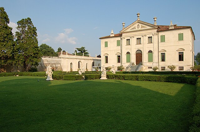
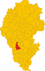
Montebello Vicentino (Montebello Vicentino)
.svg)
- Italian comune
 Hiking in Montebello Vicentino
Montebello Vicentino is a charming small town located in the Veneto region of northern Italy, surrounded by beautiful natural landscapes that offer great hiking opportunities. Here are some highlights for hiking in and around the area:
Routes and Trails
-
Montebello Vicentino Trail Network: There are several well-marked trails around Montebello that take you through forests, vineyards, and olive groves. Some trails lead to viewpoints offering stunning vistas of the surrounding hills and countryside.
-
Monte di Malo: A nearby area with a network of trails ideal for hiking. The paths vary in difficulty, making them suitable for both beginners and experienced hikers.
-
Olive Grove Trails: Walking through the ancient olive groves can be a peaceful experience. These routes often feature slight elevation changes and allow you to enjoy the rural landscape.
Points of Interest
- Castello di Montebello: While hiking, you may want to visit the historical castle that overlooks the town, offering both a cultural experience and lovely views.
- Nature Reserves: The area includes several protected natural areas where you can observe local flora and fauna while enjoying a peaceful hike.
Best Time to Hike
- Spring and Fall: These seasons provide mild weather, making them ideal for hiking. The landscape is particularly beautiful during these times, with wildflowers in bloom in spring and vibrant foliage in fall.
- Summer: Early morning hikes can be pleasant, though it can get hot later in the day, so be prepared with plenty of water and sun protection.
Tips for Hiking
- Wear Proper Footwear: Good hiking boots or shoes are essential, as trails can be uneven.
- Stay Hydrated: Always carry enough water, especially in warmer months.
- Check Local Maps: Make sure to get updated trail maps and check for any guidelines or regulations in the local area.
- Respect Nature: Stick to the paths and carry any trash out with you to preserve the beauty of the landscape.
Local Culture
After hiking, consider sampling local cuisine, which may include traditional dishes made from local produce, and participating in cultural events in Montebello Vicentino to enrich your experience.
Overall, hiking in Montebello Vicentino offers a blend of natural beauty, cultural heritage, and outdoor adventure, making it a wonderful destination for nature enthusiasts and hikers.
- Country:

- Postal Code: 36054
- Local Dialing Code: 0444
- Licence Plate Code: VI
- Coordinates: 45° 27' 0" N, 11° 23' 0" E


- GPS tracks (wikiloc): [Link]
- AboveSeaLevel: 48 м m
- Area: 21.48 sq km
- Population: 6542
- Web site: http://www.comune.montebello.vi.it
- Wikipedia en: wiki(en)
- Wikipedia: wiki(it)
- Wikidata storage: Wikidata: Q46173
- Wikipedia Commons Category: [Link]
- Freebase ID: [/m/0g8tjd]
- GeoNames ID: Alt: [6538266]
- VIAF ID: Alt: [237465369]
- OSM relation ID: [45018]
- MusicBrainz area ID: [b05c0db0-eb9c-479c-88e7-c13d281c4a4a]
- TGN ID: [1045488]
- UN/LOCODE: [ITMVO]
- Digital Atlas of the Roman Empire ID: [17841]
- NKCR AUT ID: [ge887938]
- ISTAT ID: 024060
- Italian cadastre code: F442
Shares border with regions:
Montecchio Maggiore
- Italian comune
Hiking in Montecchio Maggiore
Montecchio Maggiore, located in the Veneto region of Italy near Vicenza, is surrounded by beautiful landscapes that offer a variety of hiking opportunities. Here are some highlights:...
- Country:
- Postal Code: 36075
- Local Dialing Code: 0444
- Licence Plate Code: VI
- Coordinates: 45° 30' 13" N, 11° 24' 43" E
- GPS tracks (wikiloc): [Link]
- AboveSeaLevel: 72 м m
- Area: 30.54 sq km
- Population: 23316
- Web site: [Link]


Montorso Vicentino
- Italian comune
Hiking in Montorso Vicentino
Montorso Vicentino is a picturesque town located in the Veneto region of northern Italy. It is surrounded by beautiful landscapes, making it an ideal destination for hiking enthusiasts. The area offers various trails that cater to different skill levels, providing opportunities to explore the natural beauty of the region....
- Country:
- Postal Code: 36050
- Local Dialing Code: 0444
- Licence Plate Code: VI
- Coordinates: 45° 29' 0" N, 11° 22' 0" E
- GPS tracks (wikiloc): [Link]
- AboveSeaLevel: 118 м m
- Area: 9.29 sq km
- Population: 3107
- Web site: [Link]


Gambellara
- Italian comune
Hiking in Gambellara
Gambellara is a charming village located in the Veneto region of northeastern Italy, known for its beautiful landscapes, vineyards, and gentle hills. The area around Gambellara offers various hiking opportunities, particularly suitable for those who enjoy moderate trails and scenic views....
- Country:
- Postal Code: 36053
- Local Dialing Code: 0444
- Licence Plate Code: VI
- Coordinates: 45° 27' 35" N, 11° 20' 24" E
- GPS tracks (wikiloc): [Link]
- AboveSeaLevel: 70 м m
- Area: 13 sq km
- Population: 3432
- Web site: [Link]
Zermeghedo
- Italian comune
Hiking in Zermeghedo
Zermeghedo is a charming village located in the Veneto region of Italy, surrounded by picturesque landscapes. It offers several hiking opportunities that allow you to explore the natural beauty of the area. Here are some highlights about hiking in and around Zermeghedo:...
- Country:
- Postal Code: 36050
- Local Dialing Code: 0444
- Licence Plate Code: VI
- Coordinates: 45° 29' 0" N, 11° 22' 0" E
- GPS tracks (wikiloc): [Link]
- AboveSeaLevel: 84 м m
- Area: 2.97 sq km
- Population: 1393
- Web site: [Link]


Brendola
- Italian comune
Hiking in Brendola
Brendola is a charming town located in the province of Vicenza in northern Italy. It is surrounded by beautiful natural landscapes, including rolling hills and scenic views, making it a delightful area for hiking enthusiasts. Here's what you can expect when hiking in and around Brendola:...
- Country:
- Postal Code: 36040
- Local Dialing Code: 0444
- Licence Plate Code: VI
- Coordinates: 45° 28' 0" N, 11° 27' 0" E
- GPS tracks (wikiloc): [Link]
- AboveSeaLevel: 156 м m
- Area: 25.57 sq km
- Population: 6624
- Web site: [Link]


Sarego
- Italian comune
Hiking in Sarego
Sarego is a small municipality located in the province of Vicenza in the Veneto region of Italy. While it may not be as widely known as some other hiking destinations in Italy, it offers a charming experience for those who enjoy outdoor activities in the countryside....
- Country:
- Postal Code: 36040
- Local Dialing Code: 0444
- Licence Plate Code: VI
- Coordinates: 45° 25' 0" N, 11° 24' 0" E
- GPS tracks (wikiloc): [Link]
- AboveSeaLevel: 270 м m
- Area: 23.92 sq km
- Population: 6735
- Web site: [Link]


Lonigo
- Italian comune
Hiking in Lonigo
Lonigo is a charming town located in the Veneto region of Italy, surrounded by beautiful countryside and hills that offer various hiking opportunities. While the area may not be as famous as some of Italy's larger hiking destinations, it provides a unique blend of nature, culture, and history....
- Country:
- Postal Code: 36045
- Local Dialing Code: 0444
- Licence Plate Code: VI
- Coordinates: 45° 23' 0" N, 11° 23' 0" E
- GPS tracks (wikiloc): [Link]
- AboveSeaLevel: 31 м m
- Area: 49.42 sq km
- Population: 16466
- Web site: [Link]
Roncà
- Italian comune
Hiking in Roncà
Roncà is a charming town located in the province of Verona, in the region of Veneto, Italy. It is surrounded by beautiful landscapes that offer great opportunities for hiking enthusiasts. The area is characterized by rolling hills, vineyards, and scenic views of the surrounding mountains, making it an excellent destination for outdoor activities....
- Country:
- Postal Code: 37030
- Local Dialing Code: 045
- Licence Plate Code: VR
- Coordinates: 45° 29' 0" N, 11° 17' 0" E
- GPS tracks (wikiloc): [Link]
- AboveSeaLevel: 78 м m
- Area: 18.15 sq km
- Population: 3833
- Web site: [Link]