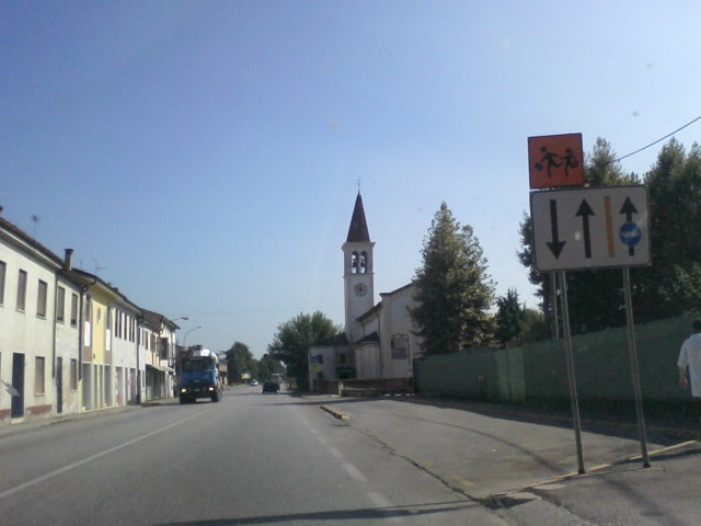
Montecchio Maggiore (Montecchio Maggiore)
.svg)
- Italian comune
 Hiking in Montecchio Maggiore
Montecchio Maggiore, located in the Veneto region of Italy near Vicenza, is surrounded by beautiful landscapes that offer a variety of hiking opportunities. Here are some highlights:
Trails and Routes
-
Mount Belmonte: This popular hike offers panoramic views of the surrounding countryside and the historic castle ruins at the summit. The trails range from easy to moderate, making it accessible for different skill levels.
-
Colle di Montecchio: This trail leads through vineyards and olive groves, providing a scenic and enjoyable hike. The gentle slopes are great for families or those looking for a leisurely walk.
-
Natural Reserve of the Lessini Mountains: A short drive from Montecchio Maggiore, this area offers a range of hiking routes. The paths here vary from easy walks to more challenging treks suitable for experienced hikers. The reserve is known for its biodiversity and unspoiled nature.
Wildlife and Flora
The region is rich in flora and fauna, and hikers may encounter various wildlife including deer and a variety of bird species. This diverse ecosystem makes hiking in the area not just a physical activity but also an opportunity for ecological exploration.
Tips for Hiking in Montecchio Maggiore
- Footwear: Wear sturdy hiking boots or shoes with good traction, especially on rocky or uneven terrain.
- Weather: Check the weather forecast before heading out, as conditions can change quickly in mountainous areas.
- Water and Snacks: Always carry enough water and some snacks to keep your energy up during your hike.
- Maps and Guidance: Use local maps or GPS apps to navigate the trails. Familiarize yourself with the routes beforehand.
- Local Regulations: Respect nature and follow local regulations, including any designated paths or signs.
Nearby Attractions
After a day of hiking, you can explore the town of Montecchio Maggiore itself, known for its historic architecture, including castles and churches. Don’t miss trying the local cuisine, which features excellent Italian wines and regional dishes.
Overall, hiking in Montecchio Maggiore can provide a wonderful blend of natural beauty, cultural history, and physical activity, making it a great destination for both casual walkers and serious hikers.
- Country:

- Postal Code: 36075
- Local Dialing Code: 0444
- Licence Plate Code: VI
- Coordinates: 45° 30' 13" N, 11° 24' 43" E


- GPS tracks (wikiloc): [Link]
- AboveSeaLevel: 72 м m
- Area: 30.54 sq km
- Population: 23316
- Web site: http://www.comune.montecchio-maggiore.vi.it/
- Wikipedia en: wiki(en)
- Wikipedia: wiki(it)
- Wikidata storage: Wikidata: Q46165
- Wikipedia Commons Category: [Link]
- Freebase ID: [/m/0g8vpl]
- GeoNames ID: Alt: [6540214]
- VIAF ID: Alt: [149363137]
- OSM relation ID: [45117]
- archINFORM location ID: [7611]
- Library of Congress authority ID: Alt: [nr91024235]
- MusicBrainz area ID: [8d80d0ab-c8d8-4128-a204-a1eff79aecf1]
- UN/LOCODE: [ITMMG]
- Gran Enciclopèdia Catalana ID: [0043732]
- Facebook Places ID: [103099073064321]
- ISTAT ID: 024061
- Italian cadastre code: F464
Shares border with regions:


Montebello Vicentino
- Italian comune
Hiking in Montebello Vicentino
Montebello Vicentino is a charming small town located in the Veneto region of northern Italy, surrounded by beautiful natural landscapes that offer great hiking opportunities. Here are some highlights for hiking in and around the area:...
- Country:
- Postal Code: 36054
- Local Dialing Code: 0444
- Licence Plate Code: VI
- Coordinates: 45° 27' 0" N, 11° 23' 0" E
- GPS tracks (wikiloc): [Link]
- AboveSeaLevel: 48 м m
- Area: 21.48 sq km
- Population: 6542
- Web site: [Link]


Montorso Vicentino
- Italian comune
Hiking in Montorso Vicentino
Montorso Vicentino is a picturesque town located in the Veneto region of northern Italy. It is surrounded by beautiful landscapes, making it an ideal destination for hiking enthusiasts. The area offers various trails that cater to different skill levels, providing opportunities to explore the natural beauty of the region....
- Country:
- Postal Code: 36050
- Local Dialing Code: 0444
- Licence Plate Code: VI
- Coordinates: 45° 29' 0" N, 11° 22' 0" E
- GPS tracks (wikiloc): [Link]
- AboveSeaLevel: 118 м m
- Area: 9.29 sq km
- Population: 3107
- Web site: [Link]
Zermeghedo
- Italian comune
Hiking in Zermeghedo
Zermeghedo is a charming village located in the Veneto region of Italy, surrounded by picturesque landscapes. It offers several hiking opportunities that allow you to explore the natural beauty of the area. Here are some highlights about hiking in and around Zermeghedo:...
- Country:
- Postal Code: 36050
- Local Dialing Code: 0444
- Licence Plate Code: VI
- Coordinates: 45° 29' 0" N, 11° 22' 0" E
- GPS tracks (wikiloc): [Link]
- AboveSeaLevel: 84 м m
- Area: 2.97 sq km
- Population: 1393
- Web site: [Link]


Castelgomberto
- Italian comune
Hiking in Castelgomberto
Castelgomberto is a charming town located in the province of Vicenza, in the Veneto region of northern Italy. While it might not be as widely known for hiking as some of its neighboring areas, there are still several outdoor opportunities nearby that are worth exploring....
- Country:
- Postal Code: 36070
- Local Dialing Code: 0445
- Licence Plate Code: VI
- Coordinates: 45° 35' 0" N, 11° 24' 0" E
- GPS tracks (wikiloc): [Link]
- AboveSeaLevel: 145 м m
- Area: 17.44 sq km
- Population: 6188
- Web site: [Link]


Brendola
- Italian comune
Hiking in Brendola
Brendola is a charming town located in the province of Vicenza in northern Italy. It is surrounded by beautiful natural landscapes, including rolling hills and scenic views, making it a delightful area for hiking enthusiasts. Here's what you can expect when hiking in and around Brendola:...
- Country:
- Postal Code: 36040
- Local Dialing Code: 0444
- Licence Plate Code: VI
- Coordinates: 45° 28' 0" N, 11° 27' 0" E
- GPS tracks (wikiloc): [Link]
- AboveSeaLevel: 156 м m
- Area: 25.57 sq km
- Population: 6624
- Web site: [Link]

Altavilla Vicentina
- Italian comune
Hiking in Altavilla Vicentina
Altavilla Vicentina, located in the Veneto region of Italy, is a charming town surrounded by beautiful landscapes and offers a variety of hiking opportunities. Here are some key points to consider if you are planning to hike in this area:...
- Country:
- Postal Code: 36077
- Local Dialing Code: 0444
- Licence Plate Code: VI
- Coordinates: 45° 31' 0" N, 11° 27' 0" E
- GPS tracks (wikiloc): [Link]
- AboveSeaLevel: 45 м m
- Area: 16.72 sq km
- Population: 12013
- Web site: [Link]
Sovizzo
- Italian comune
Hiking in Sovizzo
Sovizzo is a charming comune located in the Veneto region of northern Italy, near the city of Vicenza. While it might not be as widely known as some other hiking destinations, it offers the opportunity for peaceful walks and hikes in a picturesque setting, surrounded by gentle hills, vineyards, and lush countryside....
- Country:
- Postal Code: 36050
- Local Dialing Code: 0444
- Licence Plate Code: VI
- Coordinates: 45° 32' 0" N, 11° 27' 0" E
- GPS tracks (wikiloc): [Link]
- AboveSeaLevel: 44 м m
- Area: 15.66 sq km
- Population: 7647
- Web site: [Link]

Trissino
- Italian comune
Hiking in Trissino
Trissino, a charming town located in the province of Vicenza in the Veneto region of Italy, offers a variety of beautiful hiking opportunities. The surrounding area is characterized by picturesque landscapes, rolling hills, vineyards, and a rich cultural heritage....
- Country:
- Postal Code: 36070
- Local Dialing Code: 0445
- Licence Plate Code: VI
- Coordinates: 45° 34' 0" N, 11° 22' 0" E
- GPS tracks (wikiloc): [Link]
- AboveSeaLevel: 125 м m
- Area: 21.96 sq km
- Population: 8709
- Web site: [Link]


Arzignano
- Italian comune
Hiking in Arzignano
Arzignano is a charming town located in the Veneto region of northern Italy, surrounded by beautiful landscapes and the scenic foothills of the Alps. While Arzignano itself is known for its rich history and cultural heritage, it also offers several hiking opportunities for outdoor enthusiasts....
- Country:
- Postal Code: 36071
- Local Dialing Code: 0444
- Licence Plate Code: VI
- Coordinates: 45° 31' 13" N, 11° 20' 23" E
- GPS tracks (wikiloc): [Link]
- AboveSeaLevel: 39 м m
- Area: 34.19 sq km
- Population: 25605
- Web site: [Link]