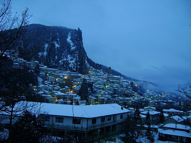
Montebello sul Sangro (Montebello sul Sangro)
- Italian comune
 Hiking in Montebello sul Sangro
Montebello sul Sangro is a charming municipality located in the Abruzzo region of Italy, surrounded by stunning natural landscapes that are perfect for hiking enthusiasts. Here’s what you can expect when hiking in and around Montebello sul Sangro:
Trails and Terrain
-
Diverse Landscape: The area features varied terrain, including forests, hills, and valleys. You can experience both easy walks and more challenging hikes depending on your fitness level and preference.
-
Mountain Trails: Trails often lead to higher elevations with breathtaking views of the surrounding Apennine Mountains. Some popular trails may take you through pine forests and along rivers, allowing you to connect with nature.
-
Nature Reserves: You might explore areas within the nearby Majella National Park or the Abruzzo-Lazio-Molise National Park, which are home to diverse flora and fauna. These parks often have established trails and interpretative signs to inform hikers about the local ecology.
Wildlife and Flora
- The region is home to a rich variety of wildlife, including deer, foxes, and various bird species. Keep an eye out for the unique flora native to this mountainous territory.
Planning Your Hike
-
Season: Spring and early fall are ideal for hiking due to milder temperatures and blooming scenery. Summer can be hot, while winter may require gear for snow-covered trails.
-
Gear: Always wear appropriate hiking boots, carry enough water, and bring a map or GPS device. Depending on the trail, trekking poles might also be helpful.
-
Guided Tours: If you’re unfamiliar with the area, consider joining a local guided hiking tour. Local guides can enhance your experience with knowledge about the history, culture, and natural features of the area.
Cultural Aspects
- Montebello sul Sangro itself has a quaint charm, with opportunities to experience local cuisine and historical sites. After a day of hiking, you can enjoy traditional Abruzzese dishes in one of the local restaurants, making for a perfect end to your outdoor adventure.
Safety Considerations
- Always inform someone of your hiking plans and expect changing weather conditions. It's recommended to check trail conditions and park alerts before heading out.
Whether you are looking for a serene walk through nature or a challenging hike up a mountain, Montebello sul Sangro offers a beautiful setting for your outdoor explorations!
- Country:

- Postal Code: 66040
- Local Dialing Code: 0872
- Licence Plate Code: CH
- Coordinates: 41° 59' 0" N, 14° 20' 0" E


- GPS tracks (wikiloc): [Link]
- AboveSeaLevel: 810 м m
- Area: 5.38 sq km
- Population: 88
- Web site: http://digilander.libero.it/montebello.test/
- Wikipedia en: wiki(en)
- Wikipedia: wiki(it)
- Wikidata storage: Wikidata: Q3562
- Wikipedia Commons Category: [Link]
- Freebase ID: [/m/0fg37g]
- GeoNames ID: Alt: [6537472]
- OSM relation ID: [41693]
- TGN ID: [7054014]
- ISTAT ID: 069009
- Italian cadastre code: B268
Shares border with regions:


Montelapiano
- Italian comune
Montelapiano is a charming village located in the Apennine Mountains of Italy, particularly known for its beautiful landscapes, tranquility, and opportunities for outdoor activities. Hiking in this area can be a rewarding experience for nature enthusiasts and those looking to explore the natural beauty of the region....
- Country:

- Postal Code: 66040
- Local Dialing Code: 0872
- Licence Plate Code: CH
- Coordinates: 41° 58' 0" N, 14° 21' 0" E


- GPS tracks (wikiloc): [Link]
- AboveSeaLevel: 740 м m
- Area: 8.27 sq km
- Population: 79
- Web site: [Link]


Civitaluparella
- Italian comune
Civitaluparella is a charming village located in the Abruzzo region of Italy, known for its stunning natural landscapes and historic architecture. It offers various hiking opportunities that cater to different skill levels, allowing hikers to explore the beautiful surroundings, including mountains, forests, and rivers....
- Country:

- Postal Code: 66040
- Local Dialing Code: 0872
- Licence Plate Code: CH
- Coordinates: 41° 57' 0" N, 14° 18' 0" E


- GPS tracks (wikiloc): [Link]
- AboveSeaLevel: 903 м m
- Area: 22.46 sq km
- Population: 327
- Web site: [Link]
Pennadomo
- Italian comune
Pennadomo, located in the Province of L'Aquila in the Abruzzo region of Italy, is a wonderful spot for hiking enthusiasts. The area is known for its stunning natural landscapes, including lush forests, rolling hills, and breathtaking views of the surrounding Apennine mountains....
- Country:

- Postal Code: 66040
- Local Dialing Code: 0872
- Licence Plate Code: CH
- Coordinates: 42° 0' 0" N, 14° 19' 0" E


- GPS tracks (wikiloc): [Link]
- AboveSeaLevel: 460 м m
- Area: 11.02 sq km
- Population: 251
- Web site: [Link]


Villa Santa Maria
- Italian comune
Villa Santa Maria is a beautiful destination located in the heart of Italy, surrounded by stunning landscapes that make it an excellent spot for hiking and outdoor activities. The area is characterized by rolling hills, lush forests, and breathtaking views of the surrounding mountains....
- Country:

- Postal Code: 66047
- Local Dialing Code: 0872
- Licence Plate Code: CH
- Coordinates: 41° 57' 5" N, 14° 21' 5" E


- GPS tracks (wikiloc): [Link]
- AboveSeaLevel: 390 м m
- Area: 16.23 sq km
- Population: 1338
- Web site: [Link]
