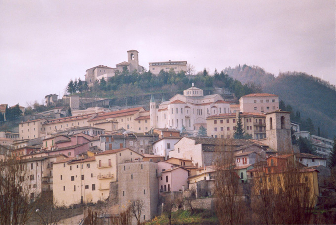
Monteleone di Spoleto (Monteleone di Spoleto)
.svg)
- Italian comune
 Hiking in Monteleone di Spoleto
Monteleone di Spoleto is a charming village located in the Umbria region of Italy, surrounded by stunning natural landscapes that make it an excellent destination for hiking enthusiasts. The area is characterized by rolling hills, dense forests, and panoramic views, providing a mix of easy-going and more challenging trails.
Hiking Trails
-
Sentiero dell’Acquedotto:
- This trail follows the route of an old aqueduct, offering scenic views and a relatively easy hike. It’s perfect for families and those looking for a more leisurely walk.
-
Monte Coscerno:
- A more challenging hike that rewards adventurers with breathtaking views at the summit. The trail takes you through dense woods and meadows, making it a great option for those seeking a longer trek.
-
Valnerina Trail:
- This is a part of a longer trail that runs through the Valnerina valley. It showcases some of the region's best natural beauty, including rivers, waterfalls, and historical sites.
Tips for Hiking in Monteleone di Spoleto
-
Seasonal Considerations: Spring and fall are ideal for hiking due to milder temperatures and vibrant scenery. Summers can get warm, while winters may present snow on higher trails.
-
Local Flora and Fauna: Keep an eye out for local wildlife, including deer and various bird species, as well as beautiful wildflowers in the spring.
-
Cultural Sites: Incorporating visits to nearby historical sites, such as ancient churches or castles, can enhance your hiking experience.
-
Preparation: Always wear appropriate hiking boots, carry plenty of water, and bring a map or GPS device. It’s also wise to check the weather before heading out.
-
Guided Tours: If you are unfamiliar with the area, consider joining a guided hiking tour. Local guides can provide valuable insights into the culture and history of Monteleone di Spoleto.
Conclusion
Hiking in Monteleone di Spoleto offers a unique blend of nature, culture, and tranquility. Whether you are looking for a casual stroll or a rigorous hike, the trails here provide something for everyone, making it an ideal spot for outdoor enthusiasts in the heart of Italy.
- Country:

- Postal Code: 06045
- Local Dialing Code: 0743
- Licence Plate Code: PG
- Coordinates: 42° 39' 5" N, 12° 57' 6" E


- GPS tracks (wikiloc): [Link]
- AboveSeaLevel: 978 м m
- Area: 62.18 sq km
- Population: 589
- Web site: http://www.comune.monteleone-di-spoleto.pg.it/
- Wikipedia en: wiki(en)
- Wikipedia: wiki(it)
- Wikidata storage: Wikidata: Q20483
- Wikipedia Commons Gallery: [Link]
- Wikipedia Commons Category: [Link]
- Freebase ID: [/m/06l68y]
- GeoNames ID: Alt: [6541113]
- VIAF ID: Alt: [159748990]
- OSM relation ID: [42116]
- MusicBrainz area ID: [1c0b5c63-1d4f-4957-a4f6-66d0b60d72da]
- ISTAT ID: 054031
- Italian cadastre code: F540
Shares border with regions:


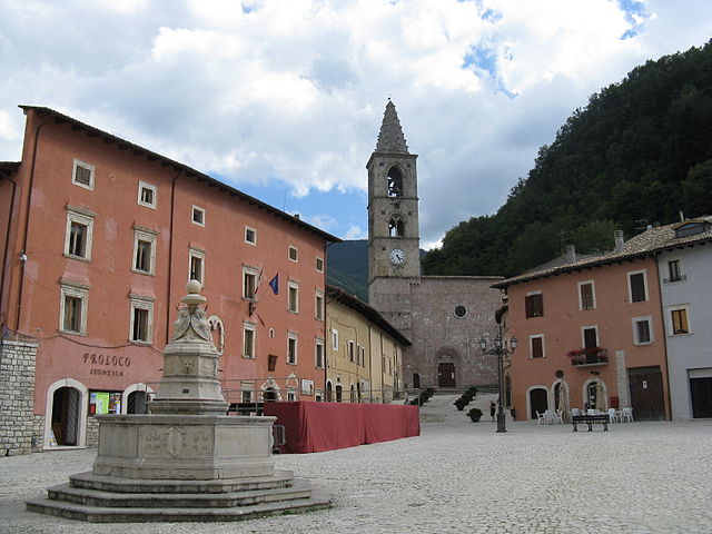
Ferentillo
- town in the region Umbria, in Italy
Hiking in Ferentillo
Ferentillo is a charming village located in the province of Terni, in the Umbria region of Italy. Nestled in the Valnerina valley, it is surrounded by stunning natural landscapes, making it an ideal destination for hiking enthusiasts. Here are some insights about hiking in and around Ferentillo:...
- Country:
- Postal Code: 05034
- Local Dialing Code: 0744
- Licence Plate Code: TR
- Coordinates: 42° 37' 17" N, 12° 47' 25" E
- GPS tracks (wikiloc): [Link]
- AboveSeaLevel: 260 м m
- Area: 69.59 sq km
- Population: 1873
- Web site: [Link]

Cascia
- Italian comune
Hiking in Cascia
Cascia, located in the Umbria region of Italy, is a beautiful destination for hiking enthusiasts. Nestled in the scenic valley of the Monti Sibillini National Park, it offers a variety of trails that cater to different skill levels. Here’s what you should know about hiking in and around Cascia:...
- Country:
- Postal Code: 06043
- Local Dialing Code: 0743
- Licence Plate Code: PG
- Coordinates: 42° 43' 0" N, 13° 1' 0" E
- GPS tracks (wikiloc): [Link]
- AboveSeaLevel: 653 м m
- Area: 180.85 sq km
- Population: 3108
- Web site: [Link]


Poggiodomo
- Italian comune
Hiking in Poggiodomo
Poggiodomo is a small town located in the province of Perugia, in the Umbria region of Italy. Surrounded by stunning natural beauty, it offers a variety of hiking opportunities that cater to different skill levels and preferences....
- Country:
- Postal Code: 06040
- Local Dialing Code: 0743
- Licence Plate Code: PG
- Coordinates: 42° 43' 0" N, 12° 56' 0" E
- GPS tracks (wikiloc): [Link]
- AboveSeaLevel: 974 м m
- Area: 40.09 sq km
- Population: 102
- Web site: [Link]


Sant'Anatolia di Narco
- Italian comune
Hiking in Sant'Anatolia di Narco
Sant'Anatolia di Narco is a charming village located in the Umbria region of Italy, surrounded by scenic landscapes, rolling hills, and lush forests, making it a great destination for hiking enthusiasts. The area offers a mix of trails that cater to different skill levels, so both beginners and experienced hikers can enjoy the natural beauty of the region....
- Country:
- Postal Code: 06040
- Local Dialing Code: 0743
- Licence Plate Code: PG
- Coordinates: 42° 44' 0" N, 12° 50' 0" E
- GPS tracks (wikiloc): [Link]
- AboveSeaLevel: 328 м m
- Area: 46.55 sq km
- Population: 557
- Web site: [Link]
Scheggino
- Italian comune
Hiking in Scheggino
Scheggino is a charming village located in the heart of Umbria, Italy, known for its picturesque landscapes, rich history, and excellent hiking opportunities. The area is characterized by rolling hills, lush valleys, and stunning views of the surrounding mountains, making it a great destination for outdoor enthusiasts....
- Country:
- Postal Code: 06040
- Local Dialing Code: 0743
- Licence Plate Code: PG
- Coordinates: 42° 43' 0" N, 12° 50' 0" E
- GPS tracks (wikiloc): [Link]
- AboveSeaLevel: 281 м m
- Area: 35.85 sq km
- Population: 452
- Web site: [Link]
Leonessa
- Italian comune
Hiking in Leonessa
Leonessa is a picturesque town located in the province of Rieti in the Lazio region of Italy, nestled in the Apennine Mountains. The area is known for its stunning landscapes, rich history, and diverse hiking opportunities. Here are some key points about hiking in and around Leonessa:...
- Country:
- Postal Code: 02016
- Local Dialing Code: 0746
- Licence Plate Code: RI
- Coordinates: 42° 34' 7" N, 12° 57' 36" E
- GPS tracks (wikiloc): [Link]
- AboveSeaLevel: 969 м m
- Area: 204.04 sq km
- Population: 2349
- Web site: [Link]