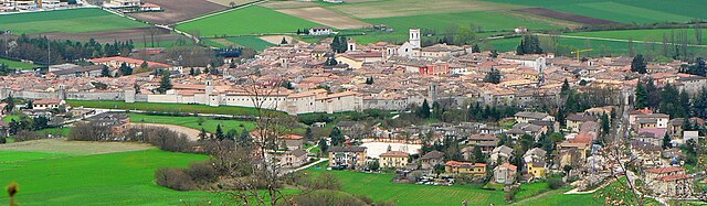
Cascia (Cascia)
.svg)
- Italian comune
 Hiking in Cascia
Cascia, located in the Umbria region of Italy, is a beautiful destination for hiking enthusiasts. Nestled in the scenic valley of the Monti Sibillini National Park, it offers a variety of trails that cater to different skill levels. Here’s what you should know about hiking in and around Cascia:
Scenic Trails
-
Cascia to Roccaporena: This trail connects Cascia to the picturesque village of Roccaporena, known for its stunning views and serene atmosphere. The route is moderate and takes you through lush landscapes and rural areas.
-
Monti Sibillini National Park: Explore the extensive network of trails in this national park, which features diverse ecosystems, unique geological formations, and breathtaking views. The park has routes ranging from easy walks to challenging hikes.
-
Forca di Presta: A popular starting point for mountain hikes, this area offers access to higher altitudes and panoramic views. Hikes from here can lead you to the peaks of the Sibillini mountains.
Considerations
-
Weather: The best time to hike in Cascia generally falls between late spring and early fall. Be sure to check weather conditions before heading out as they can change rapidly in the mountains.
-
Equipment: Good hiking boots, a map or GPS, and sufficient water and snacks are essential for a safe hiking experience.
-
Local Culture: Don’t miss the opportunity to explore Cascia’s historical and cultural sites, including the Basilica of Santa Rita, after your hikes.
Guided Tours
For those who prefer a guided experience, several local companies offer hiking tours that provide insights into the natural beauty and historical significance of the area.
By planning your hike in Cascia, you can enjoy a blend of nature, adventure, and cultural exploration!
- Country:

- Postal Code: 06043
- Local Dialing Code: 0743
- Licence Plate Code: PG
- Coordinates: 42° 43' 0" N, 13° 1' 0" E


- GPS tracks (wikiloc): [Link]
- AboveSeaLevel: 653 м m
- Area: 180.85 sq km
- Population: 3108
- Web site: http://www.comune.cascia.pg.it
- Wikipedia en: wiki(en)
- Wikipedia: wiki(it)
- Wikidata storage: Wikidata: Q20384
- Wikipedia Commons Gallery: [Link]
- Wikipedia Commons Category: [Link]
- Freebase ID: [/m/041vy2]
- GeoNames ID: Alt: [6538614]
- BnF ID: [13575480p]
- VIAF ID: Alt: [136034818]
- OSM relation ID: [42119]
- ISTAT ID: 054007
- Italian cadastre code: B948
Shares border with regions:


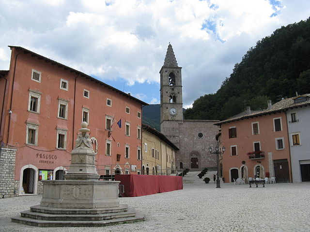
Cerreto di Spoleto
- Italian comune
Hiking in Cerreto di Spoleto
Cerreto di Spoleto is a charming village located in the Umbria region of Italy, nestled among the Apennine Mountains. This area is known for its stunning natural beauty, rich history, and well-maintained hiking trails, making it a great destination for outdoor enthusiasts....
- Country:
- Postal Code: 06040
- Local Dialing Code: 0743
- Licence Plate Code: PG
- Coordinates: 42° 49' 0" N, 12° 55' 0" E
- GPS tracks (wikiloc): [Link]
- AboveSeaLevel: 557 м m
- Area: 74.78 sq km
- Population: 1055
- Web site: [Link]


Monteleone di Spoleto
- Italian comune
Hiking in Monteleone di Spoleto
Monteleone di Spoleto is a charming village located in the Umbria region of Italy, surrounded by stunning natural landscapes that make it an excellent destination for hiking enthusiasts. The area is characterized by rolling hills, dense forests, and panoramic views, providing a mix of easy-going and more challenging trails....
- Country:
- Postal Code: 06045
- Local Dialing Code: 0743
- Licence Plate Code: PG
- Coordinates: 42° 39' 5" N, 12° 57' 6" E
- GPS tracks (wikiloc): [Link]
- AboveSeaLevel: 978 м m
- Area: 62.18 sq km
- Population: 589
- Web site: [Link]

Norcia
- Italian comune
Hiking in Norcia
Norcia, located in the Umbria region of Italy, is a fantastic destination for hiking enthusiasts. Nestled in the heart of the Sibillini Mountains, Norcia offers breathtaking landscapes, diverse trails, and rich cultural heritage....
- Country:
- Postal Code: 06046
- Local Dialing Code: 0743
- Licence Plate Code: PG
- Coordinates: 42° 47' 36" N, 13° 5' 38" E
- GPS tracks (wikiloc): [Link]
- AboveSeaLevel: 604 м m
- Area: 275.58 sq km
- Population: 4888
- Web site: [Link]


Poggiodomo
- Italian comune
Hiking in Poggiodomo
Poggiodomo is a small town located in the province of Perugia, in the Umbria region of Italy. Surrounded by stunning natural beauty, it offers a variety of hiking opportunities that cater to different skill levels and preferences....
- Country:
- Postal Code: 06040
- Local Dialing Code: 0743
- Licence Plate Code: PG
- Coordinates: 42° 43' 0" N, 12° 56' 0" E
- GPS tracks (wikiloc): [Link]
- AboveSeaLevel: 974 м m
- Area: 40.09 sq km
- Population: 102
- Web site: [Link]
Cittareale
- Italian comune
Hiking in Cittareale
Cittareale, a charming village located in the province of Rieti in Italy's Lazio region, is surrounded by stunning natural landscapes, making it an excellent destination for hiking enthusiasts. The area is characterized by its mountainous terrain, dense forests, and picturesque views, which provide a variety of trails for all skill levels....
- Country:
- Postal Code: 02010
- Local Dialing Code: 0746
- Licence Plate Code: RI
- Coordinates: 42° 37' 0" N, 13° 10' 0" E
- GPS tracks (wikiloc): [Link]
- AboveSeaLevel: 952 м m
- Area: 59.67 sq km
- Population: 462
- Web site: [Link]
Leonessa
- Italian comune
Hiking in Leonessa
Leonessa is a picturesque town located in the province of Rieti in the Lazio region of Italy, nestled in the Apennine Mountains. The area is known for its stunning landscapes, rich history, and diverse hiking opportunities. Here are some key points about hiking in and around Leonessa:...
- Country:
- Postal Code: 02016
- Local Dialing Code: 0746
- Licence Plate Code: RI
- Coordinates: 42° 34' 7" N, 12° 57' 36" E
- GPS tracks (wikiloc): [Link]
- AboveSeaLevel: 969 м m
- Area: 204.04 sq km
- Population: 2349
- Web site: [Link]