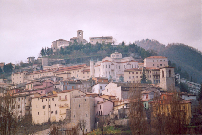
Poggiodomo (Poggiodomo)
.svg)
- Italian comune
 Hiking in Poggiodomo
Poggiodomo is a small town located in the province of Perugia, in the Umbria region of Italy. Surrounded by stunning natural beauty, it offers a variety of hiking opportunities that cater to different skill levels and preferences.
Hiking Trails
-
Furlo Gorge: Near Poggiodomo, this area features dramatic landscapes with high cliffs and the scenic River Candigliano. The trails here are great for those looking for a mix of nature and geology.
-
Monte Cucco: This mountain offers several trails that range from easy walks to more challenging hikes. The panoramic views from the top are particularly rewarding. Keep an eye out for unique rock formations and local wildlife.
-
Forest of Civitella: A beautiful area for hiking, showcasing dense woods and serene environments. This area offers more tranquil, shaded trails.
Tips for Hiking in Poggiodomo
- Preparation: Ensure you're wearing appropriate footwear and bring plenty of water, snacks, and a map or GPS device.
- Weather: The weather can change quickly, so check forecasts and be prepared for varying conditions, particularly in the mountains.
- Safety: Let someone know your hiking plans, especially if going on longer hikes or less-traveled routes.
- Respect Nature: Follow the "Leave No Trace" principles. Keep the area clean and be mindful of wildlife.
Additional Activities
- Local Culture: After hiking, take time to explore the quaint town of Poggiodomo, enjoying local cuisine and culture.
- Historical Sites: Visit nearby historical sites and medieval towns that are rich in history and offer even more hiking opportunities.
In summary, Poggiodomo offers diverse hiking experiences amidst stunning landscapes and rich cultural heritage, making it an excellent destination for outdoor enthusiasts. Enjoy your hiking adventure!
- Country:

- Postal Code: 06040
- Local Dialing Code: 0743
- Licence Plate Code: PG
- Coordinates: 42° 43' 0" N, 12° 56' 0" E


- GPS tracks (wikiloc): [Link]
- AboveSeaLevel: 974 м m
- Area: 40.09 sq km
- Population: 102
- Web site: http://www.comune.poggiodomo.pg.it
- Wikipedia en: wiki(en)
- Wikipedia: wiki(it)
- Wikidata storage: Wikidata: Q20515
- Wikipedia Commons Category: [Link]
- Freebase ID: [/m/0gm2g5]
- GeoNames ID: Alt: [6536880]
- VIAF ID: Alt: [245427479]
- OSM relation ID: [42134]
- WOEID: [720788]
- TGN ID: [7055434]
- ISTAT ID: 054042
- Italian cadastre code: G758
Shares border with regions:

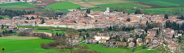
Cascia
- Italian comune
Hiking in Cascia
Cascia, located in the Umbria region of Italy, is a beautiful destination for hiking enthusiasts. Nestled in the scenic valley of the Monti Sibillini National Park, it offers a variety of trails that cater to different skill levels. Here’s what you should know about hiking in and around Cascia:...
- Country:
- Postal Code: 06043
- Local Dialing Code: 0743
- Licence Plate Code: PG
- Coordinates: 42° 43' 0" N, 13° 1' 0" E
- GPS tracks (wikiloc): [Link]
- AboveSeaLevel: 653 м m
- Area: 180.85 sq km
- Population: 3108
- Web site: [Link]


Cerreto di Spoleto
- Italian comune
Hiking in Cerreto di Spoleto
Cerreto di Spoleto is a charming village located in the Umbria region of Italy, nestled among the Apennine Mountains. This area is known for its stunning natural beauty, rich history, and well-maintained hiking trails, making it a great destination for outdoor enthusiasts....
- Country:
- Postal Code: 06040
- Local Dialing Code: 0743
- Licence Plate Code: PG
- Coordinates: 42° 49' 0" N, 12° 55' 0" E
- GPS tracks (wikiloc): [Link]
- AboveSeaLevel: 557 м m
- Area: 74.78 sq km
- Population: 1055
- Web site: [Link]


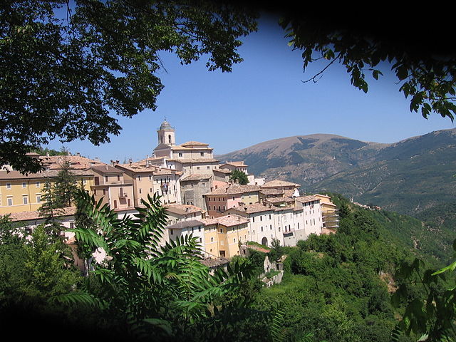
Monteleone di Spoleto
- Italian comune
Hiking in Monteleone di Spoleto
Monteleone di Spoleto is a charming village located in the Umbria region of Italy, surrounded by stunning natural landscapes that make it an excellent destination for hiking enthusiasts. The area is characterized by rolling hills, dense forests, and panoramic views, providing a mix of easy-going and more challenging trails....
- Country:
- Postal Code: 06045
- Local Dialing Code: 0743
- Licence Plate Code: PG
- Coordinates: 42° 39' 5" N, 12° 57' 6" E
- GPS tracks (wikiloc): [Link]
- AboveSeaLevel: 978 м m
- Area: 62.18 sq km
- Population: 589
- Web site: [Link]

Norcia
- Italian comune
Hiking in Norcia
Norcia, located in the Umbria region of Italy, is a fantastic destination for hiking enthusiasts. Nestled in the heart of the Sibillini Mountains, Norcia offers breathtaking landscapes, diverse trails, and rich cultural heritage....
- Country:
- Postal Code: 06046
- Local Dialing Code: 0743
- Licence Plate Code: PG
- Coordinates: 42° 47' 36" N, 13° 5' 38" E
- GPS tracks (wikiloc): [Link]
- AboveSeaLevel: 604 м m
- Area: 275.58 sq km
- Population: 4888
- Web site: [Link]

Preci
- Italian comune
Hiking in Preci
Preci, located in the beautiful region of Umbria in Italy, is an excellent destination for hiking enthusiasts. The area is characterized by its stunning landscapes, including rolling hills, lush forests, and picturesque views of the surrounding valleys. Here are some highlights about hiking in Preci:...
- Country:
- Postal Code: 06047
- Local Dialing Code: 0743
- Licence Plate Code: PG
- Coordinates: 42° 53' 0" N, 13° 2' 0" E
- GPS tracks (wikiloc): [Link]
- AboveSeaLevel: 596 м m
- Area: 82.03 sq km
- Population: 704
- Web site: [Link]


Sant'Anatolia di Narco
- Italian comune
Hiking in Sant'Anatolia di Narco
Sant'Anatolia di Narco is a charming village located in the Umbria region of Italy, surrounded by scenic landscapes, rolling hills, and lush forests, making it a great destination for hiking enthusiasts. The area offers a mix of trails that cater to different skill levels, so both beginners and experienced hikers can enjoy the natural beauty of the region....
- Country:
- Postal Code: 06040
- Local Dialing Code: 0743
- Licence Plate Code: PG
- Coordinates: 42° 44' 0" N, 12° 50' 0" E
- GPS tracks (wikiloc): [Link]
- AboveSeaLevel: 328 м m
- Area: 46.55 sq km
- Population: 557
- Web site: [Link]
Scheggino
- Italian comune
Hiking in Scheggino
Scheggino is a charming village located in the heart of Umbria, Italy, known for its picturesque landscapes, rich history, and excellent hiking opportunities. The area is characterized by rolling hills, lush valleys, and stunning views of the surrounding mountains, making it a great destination for outdoor enthusiasts....
- Country:
- Postal Code: 06040
- Local Dialing Code: 0743
- Licence Plate Code: PG
- Coordinates: 42° 43' 0" N, 12° 50' 0" E
- GPS tracks (wikiloc): [Link]
- AboveSeaLevel: 281 м m
- Area: 35.85 sq km
- Population: 452
- Web site: [Link]


Vallo di Nera
- Italian comune
Hiking in Vallo di Nera
Vallo di Nera is a beautiful village in the Umbria region of Italy, surrounded by stunning natural landscapes that make it an excellent destination for hiking enthusiasts. Here's an overview of what to expect when hiking in and around Vallo di Nera:...
- Country:
- Postal Code: 06040
- Local Dialing Code: 0743
- Licence Plate Code: PG
- Coordinates: 42° 45' 19" N, 12° 51' 52" E
- GPS tracks (wikiloc): [Link]
- AboveSeaLevel: 467 м m
- Area: 36.22 sq km
- Population: 360
- Web site: [Link]