Montenois (Montenois)

- commune in Doubs, France
 Hiking in Montenois
Montenois, a commune in the Doubs department of the Bourgogne-Franche-Comté region in eastern France, is known for its natural beauty and scenic landscapes, making it a delightful hiking destination. While it may not be as famous as some other hiking locales in France, it offers a peaceful environment for outdoor enthusiasts.
Hiking Opportunities in Montenois
-
Local Trails: Montenois has various local trails that range from easy to moderate difficulty. These paths often meander through lush forests, rolling hills, and beautiful countryside, providing stunning views of the surrounding area.
-
Natural Reserve: The nearby regions often have nature reserves or protected areas, where hikers can enjoy the local flora and fauna. You might encounter a variety of wildlife and unique plant species during your hikes.
-
Scenic Routes: Take advantage of the scenic routes that may connect Montenois to other neighboring villages or towns. These trails can provide longer hikes and the opportunity to explore the local culture and gastronomy.
-
Historical Sites: As you hike, keep an eye out for historical landmarks or ruins. Montenois has a rich history, and hiking can be a great way to explore the cultural heritage of the region.
Tips for Hiking in Montenois
-
Preparation: Make sure to check the weather forecast and prepare accordingly. Layer your clothing, and wear sturdy hiking boots.
-
Trail Maps: Before heading out, grab a trail map or download hiking apps that provide GPS navigation. Understanding the trails in advance can enhance your experience.
-
Stay Hydrated and Nourished: Bring enough water and snacks to keep your energy up during the hike.
-
Respect Nature: Follow Leave No Trace principles by staying on trails, packing out trash, and respecting wildlife.
-
Join Local Groups: If you're unfamiliar with the area, consider joining a local hiking group or guided tour to explore Montenois more safely and learn from experienced hikers.
Whether you’re an experienced hiker or a casual walker, Montenois provides a charming backdrop for your outdoor adventures. Enjoy your hike!
- Country:

- Postal Code: 25260
- Coordinates: 47° 29' 35" N, 6° 39' 58" E


- GPS tracks (wikiloc): [Link]
- Area: 8.03 sq km
- Population: 1519
- Wikipedia en: wiki(en)
- Wikipedia: wiki(fr)
- Wikidata storage: Wikidata: Q905054
- Wikipedia Commons Category: [Link]
- Freebase ID: [/m/03mgxj7]
- Freebase ID: [/m/03mgxj7]
- GeoNames ID: Alt: [6429891]
- GeoNames ID: Alt: [6429891]
- SIREN number: [212503940]
- SIREN number: [212503940]
- BnF ID: [152526200]
- BnF ID: [152526200]
- INSEE municipality code: 25394
- INSEE municipality code: 25394
Shares border with regions:


Bretigney
- commune in Doubs, France
Hiking in Bretigney
Bretigney is a charming location for hiking, surrounded by stunning natural landscapes and a rich array of trails. While it may not be as famous as some other hiking destinations, it offers a variety of paths suitable for all skill levels....
- Country:
- Postal Code: 25250
- Coordinates: 47° 29' 8" N, 6° 38' 13" E
- GPS tracks (wikiloc): [Link]
- Area: 1.83 sq km
- Population: 73
- Web site: [Link]


Arcey
- commune in Doubs, France
Hiking in Arcey
Arcey is a small commune located in the Doubs department in the Bourgogne-Franche-Comté region of eastern France. While it might not be as widely known as some other hiking destinations, it offers a picturesque setting for outdoor enthusiasts who appreciate natural beauty and quieter trails....
- Country:
- Postal Code: 25750
- Coordinates: 47° 31' 20" N, 6° 39' 39" E
- GPS tracks (wikiloc): [Link]
- Area: 12.57 sq km
- Population: 1434
- Web site: [Link]

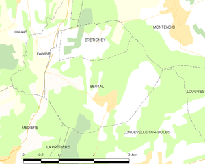
Beutal
- commune in Doubs, France
Hiking in Beutal
Beutal is a small village located in the Swiss Alps, known for its stunning natural landscapes, diverse wildlife, and numerous hiking trails. While it may not be as famous as some larger destinations in Switzerland, it offers a tranquil hiking experience for those looking to escape the crowds....
- Country:
- Postal Code: 25250
- Coordinates: 47° 28' 17" N, 6° 38' 18" E
- GPS tracks (wikiloc): [Link]
- Area: 5.78 sq km
- Population: 291
- Web site: [Link]


Faimbe
- commune in Doubs, France
Hiking in Faimbe
It seems that there might be a typographical error in the location you provided, as there is no well-known hiking destination named "Faimbe." However, if you are referring to a specific region or trail that is less popular or not widely recognized, please provide more details or check the spelling....
- Country:
- Postal Code: 25250
- Coordinates: 47° 29' 17" N, 6° 36' 49" E
- GPS tracks (wikiloc): [Link]
- Area: 1.97 sq km
- Population: 110


Sainte-Marie
- commune in Doubs, France
Hiking in Sainte-Marie
Sainte-Marie, located in the Doubs department of the Bourgogne-Franche-Comté region in eastern France, offers a range of beautiful hiking opportunities that are perfect for nature enthusiasts and outdoor adventurers. The region is characterized by its lush landscapes, rolling hills, and picturesque views typical of the Jura Mountains....
- Country:
- Postal Code: 25113
- Coordinates: 47° 30' 27" N, 6° 41' 43" E
- GPS tracks (wikiloc): [Link]
- Area: 7.17 sq km
- Population: 709


Onans
- commune in Doubs, France
Hiking in Onans
It seems there might be a typo in your question, as "Onans" does not refer to a well-known hiking destination. However, if you meant "Ohnans" in the context of Ohnan, Japan, or possibly another location, please clarify so I can provide you with accurate information....
- Country:
- Postal Code: 25250
- Coordinates: 47° 30' 8" N, 6° 36' 35" E
- GPS tracks (wikiloc): [Link]
- Area: 14.21 sq km
- Population: 363

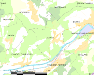
Lougres
- commune in Doubs, France
Hiking in Lougres
It seems like there may be a small confusion with the name "Lougres." As of my last training data cut-off in October 2023, there isn't a widely known hiking destination by that name. However, if you're referring to the region of Lugares or perhaps a specific location in Europe or elsewhere that sounds similar, please clarify for more detailed advice....
- Country:
- Postal Code: 25260
- Coordinates: 47° 28' 18" N, 6° 41' 12" E
- GPS tracks (wikiloc): [Link]
- Area: 5.97 sq km
- Population: 774
- Web site: [Link]