Arcey (Arcey)

- commune in Doubs, France
 Hiking in Arcey
Arcey is a small commune located in the Doubs department in the Bourgogne-Franche-Comté region of eastern France. While it might not be as widely known as some other hiking destinations, it offers a picturesque setting for outdoor enthusiasts who appreciate natural beauty and quieter trails.
Hiking Opportunities:
-
Scenic Trails: The area around Arcey features a mix of rolling hills, forests, and fields, making it ideal for picturesque hikes. The trails vary in difficulty, catering to both novice and experienced hikers.
-
Natural Beauty: The Doubs region is characterized by its lush greenery, mountainous terrain, and charming rural landscapes. Hikers can expect to see a variety of flora and fauna, with opportunities for birdwatching and enjoying the peaceful surroundings.
-
Nearby Attractions: While hiking in Arcey, you can also explore nearby attractions such as:
- The Doubs River, which offers opportunities for water activities.
- Local villages that showcase traditional architecture and the culture of the region.
-
Signposted Hiking Routes: Check local maps or resources for marked hiking routes. The French hiking federation (FFRP) often provides detailed maps for various regions, including the Doubs.
-
Multi-day Hikes: For those looking for a more extended adventure, consider linking up with longer multi-day hiking routes in the Jura Mountains or the surrounding areas.
Practical Considerations:
- Weather: Always check the weather conditions before heading out, as the weather can change quickly in mountainous areas.
- Preparation: Wear appropriate footwear and carry enough water, food, and a first-aid kit. It’s also essential to carry a map or GPS device.
- Local Regulations: Be aware of any local regulations regarding hiking and nature conservation efforts.
Conclusion:
Hiking around Arcey in the Doubs department offers a refreshing escape into nature. While it may not be on the mainstream hiking radar, it provides a wonderful experience for those looking to explore more off-the-beaten-path locations in France. Always remember to practice Leave No Trace principles to help preserve the natural beauty of the area.
- Country:

- Postal Code: 25750
- Coordinates: 47° 31' 20" N, 6° 39' 39" E


- GPS tracks (wikiloc): [Link]
- Area: 12.57 sq km
- Population: 1434
- Web site: http://arcey.fr/
- Wikipedia en: wiki(en)
- Wikipedia: wiki(fr)
- Wikidata storage: Wikidata: Q631988
- Wikipedia Commons Category: [Link]
- Freebase ID: [/m/03nnjg2]
- Freebase ID: [/m/03nnjg2]
- GeoNames ID: Alt: [6447813]
- GeoNames ID: Alt: [6447813]
- SIREN number: [212500227]
- SIREN number: [212500227]
- BnF ID: [152522488]
- BnF ID: [152522488]
- INSEE municipality code: 25022
- INSEE municipality code: 25022
Shares border with regions:


Sainte-Marie
- commune in Doubs, France
Hiking in Sainte-Marie
Sainte-Marie, located in the Doubs department of the Bourgogne-Franche-Comté region in eastern France, offers a range of beautiful hiking opportunities that are perfect for nature enthusiasts and outdoor adventurers. The region is characterized by its lush landscapes, rolling hills, and picturesque views typical of the Jura Mountains....
- Country:
- Postal Code: 25113
- Coordinates: 47° 30' 27" N, 6° 41' 43" E
- GPS tracks (wikiloc): [Link]
- Area: 7.17 sq km
- Population: 709

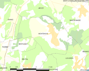
Montenois
- commune in Doubs, France
Hiking in Montenois
Montenois, a commune in the Doubs department of the Bourgogne-Franche-Comté region in eastern France, is known for its natural beauty and scenic landscapes, making it a delightful hiking destination. While it may not be as famous as some other hiking locales in France, it offers a peaceful environment for outdoor enthusiasts....
- Country:
- Postal Code: 25260
- Coordinates: 47° 29' 35" N, 6° 39' 58" E
- GPS tracks (wikiloc): [Link]
- Area: 8.03 sq km
- Population: 1519


Onans
- commune in Doubs, France
Hiking in Onans
It seems there might be a typo in your question, as "Onans" does not refer to a well-known hiking destination. However, if you meant "Ohnans" in the context of Ohnan, Japan, or possibly another location, please clarify so I can provide you with accurate information....
- Country:
- Postal Code: 25250
- Coordinates: 47° 30' 8" N, 6° 36' 35" E
- GPS tracks (wikiloc): [Link]
- Area: 14.21 sq km
- Population: 363


Saint-Julien-lès-Montbéliard
- commune in Doubs, France
Hiking in Saint-Julien-lès-Montbéliard
Saint-Julien-lès-Montbéliard is a charming commune located in the Bourgogne-Franche-Comté region of France, near the town of Montbéliard. The area is characterized by its beautiful natural landscapes, hills, and forests, making it a great destination for hiking enthusiasts....
- Country:
- Postal Code: 25550
- Coordinates: 47° 31' 20" N, 6° 42' 38" E
- GPS tracks (wikiloc): [Link]
- Area: 3.81 sq km
- Population: 168


Villers-sur-Saulnot
- commune in Haute-Saône, France
Hiking in Villers-sur-Saulnot
Villers-sur-Saulnot is a charming commune located in the Haute-Saône department in the Bourgogne-Franche-Comté region of eastern France. It offers a peaceful environment ideal for hiking enthusiasts. Here are some highlights regarding hiking in and around Villers-sur-Saulnot:...
- Country:
- Postal Code: 70400
- Coordinates: 47° 32' 58" N, 6° 38' 50" E
- GPS tracks (wikiloc): [Link]
- Area: 2.37 sq km
- Population: 136


Saulnot
- commune in Haute-Saône, France
Hiking in Saulnot
Saulnot is a quaint village located in the Bourgogne-Franche-Comté region of France, surrounded by beautiful natural landscapes that make it an appealing destination for hiking enthusiasts. The area offers a mix of scenic trails that cater to various skill levels, from leisurely walks to more challenging hikes....
- Country:
- Postal Code: 70400
- Coordinates: 47° 33' 45" N, 6° 38' 0" E
- GPS tracks (wikiloc): [Link]
- Area: 26.73 sq km
- Population: 748
- Web site: [Link]