Onans (Onans)

- commune in Doubs, France
 Hiking in Onans
It seems there might be a typo in your question, as "Onans" does not refer to a well-known hiking destination. However, if you meant "Ohnans" in the context of Ohnan, Japan, or possibly another location, please clarify so I can provide you with accurate information.
If you're looking for hiking trails in a specific area or region, I’d be happy to help you with that! Just let me know the correct name or general location you're interested in.
- Country:

- Postal Code: 25250
- Coordinates: 47° 30' 8" N, 6° 36' 35" E


- GPS tracks (wikiloc): [Link]
- Area: 14.21 sq km
- Population: 363
- Wikipedia en: wiki(en)
- Wikipedia: wiki(fr)
- Wikidata storage: Wikidata: Q905080
- Wikipedia Commons Category: [Link]
- Freebase ID: [/m/03mhbtz]
- Freebase ID: [/m/03mhbtz]
- GeoNames ID: Alt: [6429920]
- GeoNames ID: Alt: [6429920]
- SIREN number: [212504310]
- SIREN number: [212504310]
- BnF ID: [15252657b]
- BnF ID: [15252657b]
- PACTOLS thesaurus ID: [pcrtTNkZSBBUfm]
- PACTOLS thesaurus ID: [pcrtTNkZSBBUfm]
- INSEE municipality code: 25431
- INSEE municipality code: 25431
Shares border with regions:


Étrappe
- commune in Doubs, France
Hiking in Étrappe
Étrappe, located in the region of Bourgogne-Franche-Comté in France, is a small village known for its picturesque landscapes and natural surroundings. While specific hiking trails in Étrappe might not be widely documented, the region overall offers a range of outdoor activities and beautiful scenery that can be enjoyed by hiking enthusiasts....
- Country:
- Postal Code: 25250
- Coordinates: 47° 28' 27" N, 6° 34' 46" E
- GPS tracks (wikiloc): [Link]
- Area: 2.92 sq km
- Population: 207


Gémonval
- commune in Doubs, France
Hiking in Gémonval
Gémonval, while not widely known as a hiking destination, offers beautiful landscapes and trails for those looking to explore the outdoors. If you’re planning a hiking trip there, here are a few tips and information that may enhance your experience:...
- Country:
- Postal Code: 25250
- Coordinates: 47° 31' 56" N, 6° 35' 19" E
- GPS tracks (wikiloc): [Link]
- Area: 3.39 sq km
- Population: 84


Arcey
- commune in Doubs, France
Hiking in Arcey
Arcey is a small commune located in the Doubs department in the Bourgogne-Franche-Comté region of eastern France. While it might not be as widely known as some other hiking destinations, it offers a picturesque setting for outdoor enthusiasts who appreciate natural beauty and quieter trails....
- Country:
- Postal Code: 25750
- Coordinates: 47° 31' 20" N, 6° 39' 39" E
- GPS tracks (wikiloc): [Link]
- Area: 12.57 sq km
- Population: 1434
- Web site: [Link]


Faimbe
- commune in Doubs, France
Hiking in Faimbe
It seems that there might be a typographical error in the location you provided, as there is no well-known hiking destination named "Faimbe." However, if you are referring to a specific region or trail that is less popular or not widely recognized, please provide more details or check the spelling....
- Country:
- Postal Code: 25250
- Coordinates: 47° 29' 17" N, 6° 36' 49" E
- GPS tracks (wikiloc): [Link]
- Area: 1.97 sq km
- Population: 110

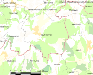
Courchaton
- commune in Haute-Saône, France
Hiking in Courchaton
As of my last knowledge update in October 2023, Courchaton doesn't appear to be a widely recognized hiking destination, so I may need more specific information on its location or features. However, if you are seeking hiking opportunities in lesser-known areas, there are a few general tips and considerations....
- Country:
- Postal Code: 70110
- Coordinates: 47° 30' 59" N, 6° 32' 25" E
- GPS tracks (wikiloc): [Link]
- Area: 13.53 sq km
- Population: 452


Geney
- commune in Doubs, France
Hiking in Geney
It seems like there might be a small typo in your request for information on hiking in "Geney." If you meant Geneva, which is renowned for its proximity to beautiful hiking trails in the surrounding mountains, specifically the Jura and the Alps, I’d be happy to help with that!...
- Country:
- Postal Code: 25250
- Coordinates: 47° 29' 9" N, 6° 34' 0" E
- GPS tracks (wikiloc): [Link]
- Area: 4.33 sq km
- Population: 131

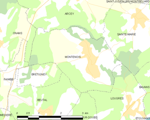
Montenois
- commune in Doubs, France
Hiking in Montenois
Montenois, a commune in the Doubs department of the Bourgogne-Franche-Comté region in eastern France, is known for its natural beauty and scenic landscapes, making it a delightful hiking destination. While it may not be as famous as some other hiking locales in France, it offers a peaceful environment for outdoor enthusiasts....
- Country:
- Postal Code: 25260
- Coordinates: 47° 29' 35" N, 6° 39' 58" E
- GPS tracks (wikiloc): [Link]
- Area: 8.03 sq km
- Population: 1519


Marvelise
- commune in Doubs, France
Hiking in Marvelise
Marvelise is a beautiful yet less-known region that offers incredible hiking opportunities. Nestled in nature, it provides a balance of scenic landscapes, diverse ecosystems, and trails suitable for varying skill levels. Here are some key points to consider when hiking in Marvelise:...
- Country:
- Postal Code: 25250
- Coordinates: 47° 31' 20" N, 6° 35' 32" E
- GPS tracks (wikiloc): [Link]
- Area: 4.21 sq km
- Population: 158


Médière
- commune in Doubs, France
Hiking in Médière
Médière, located in the beautiful region of the French Alps, is known for its stunning landscapes and a variety of hiking trails suitable for different skill levels. Here are some key points you might find helpful when considering a hiking trip in Médière:...
- Country:
- Postal Code: 25250
- Coordinates: 47° 27' 24" N, 6° 35' 55" E
- GPS tracks (wikiloc): [Link]
- Area: 5.73 sq km
- Population: 302