
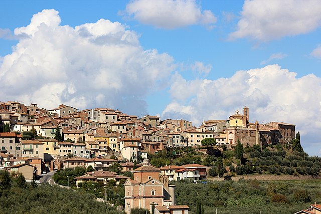
Montepulciano (Montepulciano)
.svg)
- Italian comune
 Hiking in Montepulciano
Hiking in Montepulciano, a historic town in the Tuscany region of Italy, offers a unique blend of natural beauty, rich history, and stunning landscapes. Here are some key points to consider when planning a hiking trip in this picturesque area:
Scenic Trails
-
Vinedock Trails: The area surrounding Montepulciano is famous for its vineyards, especially those producing Vino Nobile di Montepulciano. Many hiking trails wind through these vineyards, providing stunning views and opportunities to taste local wines.
-
Countryside Paths: The rolling hills of Tuscany provide numerous paths that allow hikers to experience the idyllic Tuscan countryside. Trails often lead through olive groves, cypress-lined roads, and picturesque villages.
-
Nature Reserves: Nearby areas such as the Val d’Orcia Natural Park offer more rugged hiking options. Here, you'll find diverse flora and fauna, as well as dramatic landscapes with beautiful panoramas.
Difficulty Levels
- Range of Trails: There are hiking options for all levels, from easy walks along vineyard trails to more challenging hikes in the surrounding hills and nature reserves. Make sure to choose a trail that matches your fitness level and experience.
Best Time to Hike
- Spring and Fall: The best time for hiking in Montepulciano is during the spring (April to June) and fall (September to November). During these seasons, the weather is mild, and the landscapes are particularly beautiful with blooming flowers or autumn colors.
Local Culture
- Historical Experience: While hiking, you'll have the chance to explore historical sites, such as ancient churches and fortifications. Montepulciano itself is a wonderful place to wander after a hike, with its Renaissance architecture, quaint streets, and excellent dining options.
Essential Tips
- Hydration and Gear: Always bring enough water, wear sturdy hiking shoes, and dress in layers, as weather can change quickly in the hills.
- Map and Navigation: It’s advisable to have a map of the hiking trails or use a reliable hiking app. Some trails might not be well-marked.
Guided Tours
- If you prefer a guided experience, consider joining a local hiking tour, which can enhance your understanding of the area’s history and ecology.
Overall, hiking in Montepulciano is a rewarding experience, offering breathtaking views, physical activity, and cultural immersion. Whether you're a beginner or an experienced hiker, this beautiful part of Tuscany has something for everyone.
- Country:

- Postal Code: 53045
- Local Dialing Code: 0578
- Licence Plate Code: SI
- Coordinates: 43° 6' 0" N, 11° 47' 0" E


- GPS tracks (wikiloc): [Link]
- AboveSeaLevel: 605 м m
- Area: 165.33 sq km
- Population: 13984
- Web site: http://www.comune.montepulciano.siena.it
- Wikipedia en: wiki(en)
- Wikipedia: wiki(it)
- Wikidata storage: Wikidata: Q91217
- Wikipedia Commons Gallery: [Link]
- Wikipedia Commons Category: [Link]
- Freebase ID: [/m/06ywg0]
- GeoNames ID: Alt: [6541611]
- VIAF ID: Alt: [167530550]
- OSM relation ID: [42308]
- GND ID: Alt: [4115211-6]
- archINFORM location ID: [1096]
- MusicBrainz area ID: [d2353a71-a64e-4d7a-bd7c-e74e2c1ca33c]
- Quora topic ID: [Montepulciano-1]
- UN/LOCODE: [ITMPC]
- Encyclopædia Britannica Online ID: [place/Montepulciano]
- DMOZ ID: Alt: [Regional/Europe/Italy/Tuscany/Localities/Montepulciano/]
- Store norske leksikon ID: [Montepulciano]
- ISTAT ID: 052015
- Italian cadastre code: F592
Shares border with regions:

Castiglione del Lago
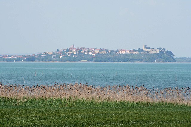
- town in Italy
Hiking in Castiglione del Lago
Castiglione del Lago is a charming town located on the shores of Lake Trasimeno in the Umbria region of Italy. It's a beautiful destination for hiking enthusiasts, offering scenic landscapes, historical sites, and a variety of terrains....
- Country:
- Postal Code: 06061
- Local Dialing Code: 075
- Licence Plate Code: PG
- Coordinates: 43° 7' 38" N, 12° 2' 43" E
- GPS tracks (wikiloc): [Link]
- AboveSeaLevel: 304 м m
- Area: 205.26 sq km
- Population: 15479
- Web site: [Link]


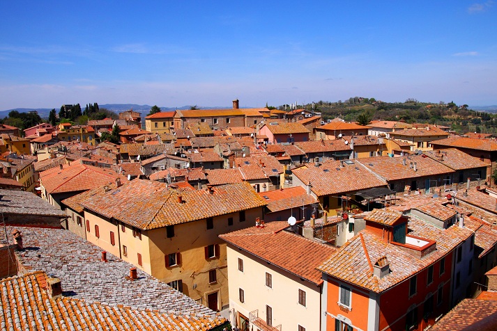
Cortona
- Italian town and comune
Hiking in Cortona
Cortona, a charming hilltop town in Tuscany, Italy, is known not only for its historical architecture and stunning views but also for its scenic hiking opportunities. Here are some key points about hiking in and around Cortona:...
- Country:
- Postal Code: 52044
- Local Dialing Code: 0575
- Licence Plate Code: AR
- Coordinates: 43° 16' 32" N, 11° 59' 17" E
- GPS tracks (wikiloc): [Link]
- AboveSeaLevel: 494 м m
- Area: 342.97 sq km
- Population: 22057
- Web site: [Link]

Chianciano Terme
- Italian comune
Hiking in Chianciano Terme
Chianciano Terme is a charming town in the Tuscany region of Italy, known primarily for its thermal spas, but it also offers beautiful hiking opportunities in the surrounding countryside. Here's an overview of what you can expect when hiking in and around Chianciano Terme:...
- Country:
- Postal Code: 53042
- Local Dialing Code: 0578
- Licence Plate Code: SI
- Coordinates: 43° 4' 0" N, 11° 50' 0" E
- GPS tracks (wikiloc): [Link]
- AboveSeaLevel: 475 м m
- Area: 36.58 sq km
- Population: 7050
- Web site: [Link]

Chiusi
- Italian comune
Hiking in Chiusi
Chiusi, a charming town in the Tuscany region of Italy, is not only rich in history and culture but also offers some beautiful hiking opportunities. Nestled in the rolling hills and surrounded by picturesque landscapes, Chiusi serves as an excellent base for exploring the natural beauty of the area. Here are some highlights and tips for hiking in and around Chiusi:...
- Country:
- Postal Code: 53043
- Local Dialing Code: 0578
- Licence Plate Code: SI
- Coordinates: 43° 1' 0" N, 11° 57' 0" E
- GPS tracks (wikiloc): [Link]
- AboveSeaLevel: 398 м m
- Area: 58.15 sq km
- Population: 8558
- Web site: [Link]


Pienza
- Italian comune
Hiking in Pienza
Pienza, located in the beautiful Tuscany region of Italy, is a charming town known for its stunning landscapes, Renaissance architecture, and rich cultural heritage. It's also surrounded by some fantastic hiking opportunities that showcase the scenic beauty of the Val d'Orcia region. Here are some important aspects to consider when hiking in and around Pienza:...
- Country:
- Postal Code: 53026
- Local Dialing Code: 0578
- Licence Plate Code: SI
- Coordinates: 43° 4' 43" N, 11° 40' 44" E
- GPS tracks (wikiloc): [Link]
- AboveSeaLevel: 491 м m
- Area: 122.96 sq km
- Population: 2082
- Web site: [Link]


Torrita di Siena
- Italian comune
Hiking in Torrita di Siena
Torrita di Siena, located in the beautiful Tuscany region of Italy, offers a fantastic backdrop for hiking enthusiasts. Here are some highlights about hiking in and around this charming medieval town:...
- Country:
- Postal Code: 53049
- Local Dialing Code: 0577
- Licence Plate Code: SI
- Coordinates: 43° 10' 0" N, 11° 46' 0" E
- GPS tracks (wikiloc): [Link]
- AboveSeaLevel: 325 м m
- Area: 58.24 sq km
- Population: 7276
- Web site: [Link]