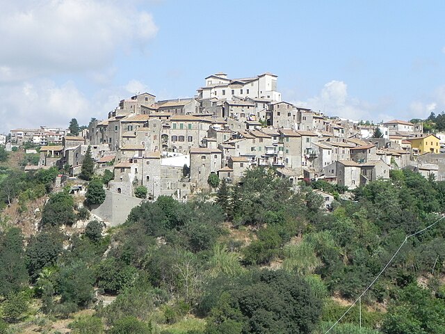
Monterotondo (Monterotondo)
.svg)
- Italian comune
 Hiking in Monterotondo
Monterotondo, located near Rome, Italy, offers a blend of natural beauty and cultural heritage, making it a great location for hiking enthusiasts. The area is characterized by scenic landscapes, ancient ruins, and charming countryside.
Hiking Trails
-
Parco Regionale dell'Appia Antica: While slightly further from Monterotondo, this park offers stunning trails along ancient Roman roads. You can combine your hike with a bit of history, exploring ruins and ancient sites.
-
Monte Gennaro: A popular destination for hikers, this mountain offers several trails of varying difficulty. The views from the top are breathtaking, providing a panoramic look at the surrounding countryside.
-
Bosco di Civitella: This area is part of the larger Natural Reserve of Monte Soratte. Trails wind through lush forests, giving hikers an opportunity to experience local flora and fauna. It’s suitable for a more relaxed hike, ideal for families.
Best Times to Hike
- Spring (March to May): The weather is mild, flowers are blooming, and the trails are less crowded.
- Fall (September to November): Cooler temperatures and stunning autumn colors make for a picturesque hiking experience.
Tips for Hiking in Monterotondo
- Stay Hydrated: Always carry enough water, especially in the warmer months.
- Wear Proper Footwear: Good hiking shoes will provide the necessary support and grip needed for diverse terrain.
- Check Local Guides: Guides or maps can provide vital information on trail conditions and difficulty levels.
- Respect Nature: Follow local guidelines for keeping the trails clean and safe.
Accessibility
Monterotondo is easily accessible from Rome via public transport, making it a great day trip for those staying in the city. Always check public transport schedules to plan your return.
Conclusion
Whether you're looking for a challenging trek, a leisurely stroll, or a chance to explore local history, Monterotondo offers a variety of hiking experiences. Enjoy the rich landscape and take in the historical significance of this beautiful region!
- Country:

- Postal Code: 00015; 00015, 00016 (Scalo)
- Local Dialing Code: 06
- Licence Plate Code: ROMA
- Coordinates: 42° 3' 0" N, 12° 37' 0" E


- GPS tracks (wikiloc): [Link]
- AboveSeaLevel: 165 м m
- Area: 40.94 sq km
- Population: 41144
- Web site: http://www.comune.monterotondo.rm.it
- Wikipedia en: wiki(en)
- Wikipedia: wiki(it)
- Wikidata storage: Wikidata: Q242998
- Wikipedia Commons Category: [Link]
- Freebase ID: [/m/08qfnk]
- GeoNames ID: Alt: [6539762]
- VIAF ID: Alt: [133755370]
- OSM relation ID: [41752]
- GND ID: Alt: [4451902-3]
- archINFORM location ID: [12562]
- MusicBrainz area ID: [82a5ed2d-fa7e-4c13-935a-0cc3730a2ff5]
- Quora topic ID: [Monterotondo]
- UN/LOCODE: [ITMTD]
- Gran Enciclopèdia Catalana ID: [0043776]
- ISTAT ID: 058065
- Italian cadastre code: F611
Shares border with regions:


Rome
- capital and largest city of Italy
Hiking in Rome
Hiking in and around Rome offers a unique way to explore not just the historic city itself but also the beautiful landscapes and trails in the surrounding areas. While most visitors focus on the city’s famous landmarks, hiking provides a different perspective and a chance to escape the hustle and bustle. Here are some great options for hiking in Rome and its surroundings:...
- Country:
- Postal Code: 00118–00199
- Local Dialing Code: 06
- Licence Plate Code: RM
- Coordinates: 41° 53' 35" N, 12° 28' 58" E
- GPS tracks (wikiloc): [Link]
- AboveSeaLevel: 21 м m
- Area: 1287.36 sq km
- Population: 2873494
- Web site: [Link]


Capena
- Italian comune
Hiking in Capena
Capena is a charming town located in the Lazio region of Italy, close to Rome, and offers several hiking opportunities for both beginners and experienced hikers. The surrounding area features a mix of natural beauty and historical significance, making it an attractive destination for outdoor enthusiasts....
- Country:
- Postal Code: 00060
- Local Dialing Code: 06
- Licence Plate Code: ROMA
- Coordinates: 42° 8' 25" N, 12° 32' 25" E
- GPS tracks (wikiloc): [Link]
- AboveSeaLevel: 160 м m
- Area: 29.51 sq km
- Population: 10799
- Web site: [Link]

Castelnuovo di Porto
- Italian comune
Hiking in Castelnuovo di Porto
Castelnuovo di Porto, located in the Lazio region of Italy, offers a variety of beautiful hiking opportunities that showcase the region's natural beauty and history. Nestled between the Tiber River and the hills of the Sabina region, the area is characterized by its picturesque landscapes, rolling hills, and charming medieval architecture....
- Country:
- Postal Code: 00060
- Local Dialing Code: 06
- Licence Plate Code: ROMA
- Coordinates: 42° 7' 40" N, 12° 30' 0" E
- GPS tracks (wikiloc): [Link]
- AboveSeaLevel: 250 м m
- Area: 30.57 sq km
- Population: 8564
- Web site: [Link]
Fonte Nuova
- Italian comune
Hiking in Fonte Nuova
Fonte Nuova is a charming area located just outside of Rome, Italy, known for its natural beauty and outdoor activities, including hiking. The region offers various trails that range from easy walks to more challenging hikes, making it suitable for hikers of all levels....
- Country:
- Postal Code: 00013
- Local Dialing Code: 06
- Licence Plate Code: RM
- Coordinates: 42° 0' 6" N, 12° 37' 19" E
- GPS tracks (wikiloc): [Link]
- AboveSeaLevel: 150 м m
- Area: 19.94 sq km
- Population: 33193
- Web site: [Link]


Mentana
- Italian comune
Hiking in Mentana
Mentana is a charming town located in the Lazio region of Italy, not far from Rome. It offers various hiking opportunities, thanks to its picturesque landscapes and proximity to natural reserves and scenic hills....
- Country:
- Postal Code: 00013
- Local Dialing Code: 06
- Licence Plate Code: RM
- Coordinates: 42° 2' 1" N, 12° 38' 40" E
- GPS tracks (wikiloc): [Link]
- AboveSeaLevel: 150 м m
- Area: 24.27 sq km
- Population: 23126
- Web site: [Link]


Montelibretti
- Italian comune
Hiking in Montelibretti
Montelibretti is a charming area located in the province of Rome, Italy. Known for its scenic landscapes and historical sites, it offers a unique hiking experience for nature enthusiasts and history buffs alike. Here are some key points about hiking in Montelibretti:...
- Country:
- Postal Code: 00010
- Local Dialing Code: 0774
- Licence Plate Code: ROMA
- Coordinates: 42° 8' 0" N, 12° 44' 0" E
- GPS tracks (wikiloc): [Link]
- AboveSeaLevel: 232 м m
- Area: 45.43 sq km
- Population: 5326
- Web site: [Link]
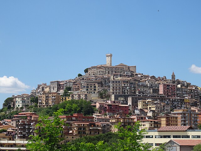

Palombara Sabina
- Italian comune
Hiking in Palombara Sabina
Palombara Sabina, located in the Lazio region of Italy, is a charming town known for its picturesque landscapes and a variety of hiking opportunities. Nestled in the Sabine Hills, it offers a mix of natural beauty, historical sites, and beautiful trails that are perfect for both beginner and experienced hikers....
- Country:
- Postal Code: 00018
- Local Dialing Code: 0774
- Licence Plate Code: ROMA
- Coordinates: 42° 4' 0" N, 12° 46' 0" E
- GPS tracks (wikiloc): [Link]
- AboveSeaLevel: 372 м m
- Area: 75.8 sq km
- Population: 13200
- Web site: [Link]
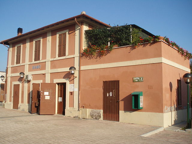

Riano, Lazio
- Italian comune
Hiking in Riano, Lazio
Riano, located in the Lazio region of Italy just north of Rome, offers a variety of hiking opportunities that combine stunning natural beauty with historical and cultural sites. Here are some key highlights for hikers considering this area:...
- Country:
- Postal Code: 00060
- Local Dialing Code: 06
- Licence Plate Code: ROMA
- Coordinates: 42° 5' 28" N, 12° 31' 22" E
- GPS tracks (wikiloc): [Link]
- AboveSeaLevel: 125 м m
- Area: 25.43 sq km
- Population: 10649
- Web site: [Link]