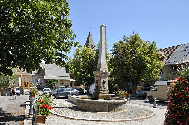
Montgardin (Montgardin)
- commune in Hautes-Alpes, France
Montgardin, located in the Hautes-Alpes region of France, offers beautiful hiking opportunities in the heart of the French Alps. The area is known for its stunning alpine landscapes, including mountains, valleys, and picturesque villages. Here are some highlights to consider when planning a hike in Montgardin:
Hiking Trails
-
Trail Varieties: Montgardin has a range of trails suitable for different skill levels, from easy walks to challenging hikes. You can find marked paths that lead through scenic forests and meadows.
-
Views: Many trails offer breathtaking views of the surrounding mountains and valleys. Sunrise and sunset hikes can be particularly stunning.
-
Nature: The region is rich in biodiversity. Keep an eye out for local wildlife, including deer, various birds, and unique alpine flora.
-
Historical Sites: Some trails may take you near historical landmarks or ancient ruins, adding a cultural element to your hike.
Practical Considerations
- Weather: The weather can change rapidly in the mountains, so check the forecast before you set out and dress in layers.
- Gear: Proper hiking gear is essential. Ensure you have good hiking shoes, a backpack, water, snacks, and a map or GPS device.
- Safety: Always inform someone about your hiking plans, carry a first-aid kit, and know your skill level to choose an appropriate trail.
Local Recommendations
- Guided Tours: If you are unfamiliar with the area, consider joining a guided hike. Local guides can provide insights into the terrain and natural history.
- Accommodation: There are various options for accommodation in Montgardin, from cozy lodges to camping sites, if you plan to extend your stay.
Getting There
- Montgardin is accessible by public transport and car. Make sure to plan your route ahead of time.
Conclusion
Montgardin is a fantastic destination for hikers looking to experience the beauty of the French Alps. Whether you're seeking solitude in nature or an adventurous trek, you'll find something that fits your needs. Always prioritize safety and preparedness to maximize your enjoyment of the experience!
- Country:

- Postal Code: 05230
- Coordinates: 44° 33' 1" N, 6° 14' 23" E


- GPS tracks (wikiloc): [Link]
- Area: 15.32 sq km
- Population: 462
- Web site: http://montgardin.valleedelavance.com
- Wikipedia en: wiki(en)
- Wikipedia: wiki(fr)
- Wikidata storage: Wikidata: Q1086243
- Wikipedia Commons Category: [Link]
- Freebase ID: [/m/03mfmp2]
- Freebase ID: [/m/03mfmp2]
- GeoNames ID: Alt: [2992563]
- GeoNames ID: Alt: [2992563]
- SIREN number: [210500849]
- SIREN number: [210500849]
- INSEE municipality code: 05084
- INSEE municipality code: 05084
Shares border with regions:

Avançon
- commune in Hautes-Alpes, France
Avançon is a picturesque commune in the Hautes-Alpes department of southeastern France, located in the southern Alps. This region is known for its stunning landscapes, including mountains, valleys, and clear rivers, which make it an excellent destination for hiking enthusiasts....
- Country:

- Postal Code: 05230
- Coordinates: 44° 31' 31" N, 6° 11' 7" E


- GPS tracks (wikiloc): [Link]
- Area: 22.57 sq km
- Population: 402

Chorges
- commune in Hautes-Alpes, France
Chorges, located in the Hautes-Alpes region of France, is a beautiful destination for hiking enthusiasts. Nestled in the stunning natural environment of the French Alps, it offers a range of trails suitable for all levels of hikers, from beginners to experienced trekkers. Here’s what you need to know about hiking in Chorges:...
- Country:

- Postal Code: 05230
- Coordinates: 44° 32' 44" N, 6° 16' 35" E


- GPS tracks (wikiloc): [Link]
- AboveSeaLevel: 835 м m
- Area: 53.34 sq km
- Population: 2810
- Web site: [Link]

Espinasses
- commune in Hautes-Alpes, France
Espinasses is a charming village located in the French Alps, in the department of Hautes-Alpes. It offers a variety of hiking opportunities suitable for different skill levels, surrounded by stunning natural beauty....
- Country:

- Postal Code: 05190
- Coordinates: 44° 28' 0" N, 6° 13' 29" E


- GPS tracks (wikiloc): [Link]
- Area: 13.86 sq km
- Population: 728
- Web site: [Link]

La Bâtie-Neuve
- commune in Hautes-Alpes, France
La Bâtie-Neuve is a picturesque village located in the Hautes-Alpes region of southeastern France. It's an excellent destination for hiking enthusiasts due to its stunning natural surroundings, including the nearby Écrins National Park and the breathtaking landscapes of the Alps....
- Country:

- Postal Code: 05230
- Coordinates: 44° 34' 0" N, 6° 11' 45" E


- GPS tracks (wikiloc): [Link]
- Area: 27.99 sq km
- Population: 2487
- Web site: [Link]
