La Bâtie-Neuve (La Bâtie-Neuve)
- commune in Hautes-Alpes, France
 Hiking in La Bâtie-Neuve
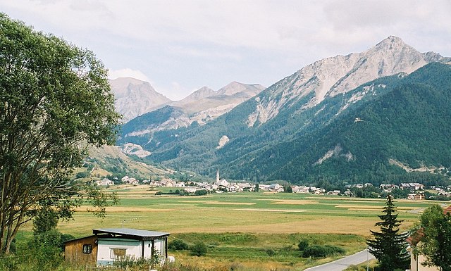
La Bâtie-Neuve is a picturesque village located in the Hautes-Alpes region of southeastern France. It's an excellent destination for hiking enthusiasts due to its stunning natural surroundings, including the nearby Écrins National Park and the breathtaking landscapes of the Alps.
Popular Hiking Routes:
-
Sentier du Col de la Pisse: This trail offers beautiful views and a moderate hike that can be enjoyed by various skill levels. It's a great way to experience the alpine flora and fauna.
-
Le Val de la Clarée: While a bit further from La Bâtie-Neuve, this stunning valley features a series of breathtaking trails that lead through forests and along rivers, showcasing the area’s natural beauty.
-
Pic de Bure: For those seeking a challenging hike, the Pic de Bure offers stunning panoramic views of the surrounding mountains. It requires a good level of fitness, but the rewards are incredible.
Tips for Hiking in La Bâtie-Neuve:
- Prepare Appropriately: Check the weather forecast and dress in layers. The alpine climate can change quickly.
- Footwear: Sturdy and comfortable hiking boots are essential, especially on rocky or uneven terrain.
- Stay Hydrated: Bring sufficient water, especially on longer hikes.
- Respect Nature: Stick to marked trails, and remember to follow the “Leave No Trace” principles to preserve the area's natural beauty.
- Local Regulations: Always check for any local regulations or requirements, especially in national parks, since some areas may require permits.
Accessibility:
La Bâtie-Neuve is accessible by road and is a great base for exploring the surrounding hiking routes. There are accommodations available in the village and nearby areas, ranging from hotels to camping sites.
Overall, hiking in and around La Bâtie-Neuve offers an excellent opportunity to experience the beauty of the French Alps, making it a wonderful choice for outdoor enthusiasts. Whether you're looking for leisurely walks or more challenging treks, the area has something for everyone.
- Country:

- Postal Code: 05230
- Coordinates: 44° 34' 0" N, 6° 11' 45" E


- GPS tracks (wikiloc): [Link]
- Area: 27.99 sq km
- Population: 2487
- Web site: http://commune-la-batie-neuve.fr
- Wikipedia en: wiki(en)
- Wikipedia: wiki(fr)
- Wikidata storage: Wikidata: Q865592
- Wikipedia Commons Category: [Link]
- Freebase ID: [/m/02vqcdd]
- Freebase ID: [/m/02vqcdd]
- GeoNames ID: Alt: [6456657]
- GeoNames ID: Alt: [6456657]
- SIREN number: [210500179]
- SIREN number: [210500179]
- INSEE municipality code: 05017
- INSEE municipality code: 05017
Shares border with regions:
Ancelle
- commune in Hautes-Alpes, France
Hiking in Ancelle
Ancelle is a charming village located in the French Alps, specifically in the Hautes-Alpes department. It's a great destination for hiking enthusiasts looking for a mix of natural beauty, alpine scenery, and a variety of trails suitable for different skill levels. Here are some insights into hiking in Ancelle:...
- Country:
- Postal Code: 05260
- Coordinates: 44° 37' 24" N, 6° 12' 24" E
- GPS tracks (wikiloc): [Link]
- Area: 50.66 sq km
- Population: 905

La Bâtie-Vieille
- commune in Hautes-Alpes, France
Hiking in La Bâtie-Vieille
La Bâtie-Vieille, a small village located in the French Alps, offers beautiful hiking opportunities and stunning natural scenery. Here are some key points to consider if you're planning to hike in this region:...
- Country:
- Postal Code: 05000
- Coordinates: 44° 33' 14" N, 6° 9' 45" E
- GPS tracks (wikiloc): [Link]
- Area: 9.05 sq km
- Population: 346
- Web site: [Link]
Montgardin
- commune in Hautes-Alpes, France
Hiking in Montgardin
Montgardin, located in the Hautes-Alpes region of France, offers beautiful hiking opportunities in the heart of the French Alps. The area is known for its stunning alpine landscapes, including mountains, valleys, and picturesque villages. Here are some highlights to consider when planning a hike in Montgardin:...
- Country:
- Postal Code: 05230
- Coordinates: 44° 33' 1" N, 6° 14' 23" E
- GPS tracks (wikiloc): [Link]
- Area: 15.32 sq km
- Population: 462
- Web site: [Link]

Avançon
- commune in Hautes-Alpes, France
Hiking in Avançon
Avançon is a picturesque commune in the Hautes-Alpes department of southeastern France, located in the southern Alps. This region is known for its stunning landscapes, including mountains, valleys, and clear rivers, which make it an excellent destination for hiking enthusiasts....
- Country:
- Postal Code: 05230
- Coordinates: 44° 31' 31" N, 6° 11' 7" E
- GPS tracks (wikiloc): [Link]
- Area: 22.57 sq km
- Population: 402
Chorges
- commune in Hautes-Alpes, France
Hiking in Chorges
Chorges, located in the Hautes-Alpes region of France, is a beautiful destination for hiking enthusiasts. Nestled in the stunning natural environment of the French Alps, it offers a range of trails suitable for all levels of hikers, from beginners to experienced trekkers. Here’s what you need to know about hiking in Chorges:...
- Country:
- Postal Code: 05230
- Coordinates: 44° 32' 44" N, 6° 16' 35" E
- GPS tracks (wikiloc): [Link]
- AboveSeaLevel: 835 м m
- Area: 53.34 sq km
- Population: 2810
- Web site: [Link]

La Rochette
- commune in Hautes-Alpes, France
Hiking in La Rochette
La Rochette, located in the Hautes-Alpes region of southeastern France, offers a fantastic setting for hiking enthusiasts. The area is characterized by stunning alpine landscapes, diverse ecosystems, and a plethora of trails catering to various skill levels....
- Country:
- Postal Code: 05000
- Coordinates: 44° 35' 41" N, 6° 9' 22" E
- GPS tracks (wikiloc): [Link]
- Area: 10.34 sq km
- Population: 472