Chorges (Chorges)
- commune in Hautes-Alpes, France
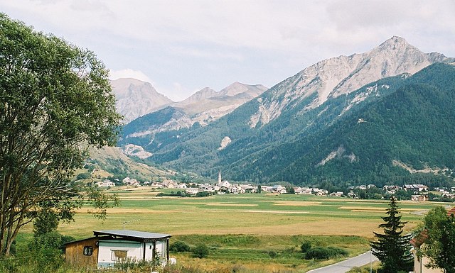
Chorges, located in the Hautes-Alpes region of France, is a beautiful destination for hiking enthusiasts. Nestled in the stunning natural environment of the French Alps, it offers a range of trails suitable for all levels of hikers, from beginners to experienced trekkers. Here’s what you need to know about hiking in Chorges:
Trails and Routes
-
Lake Serre-Ponçon: The area around Lake Serre-Ponçon provides several scenic trails with views of the lake and mountains. The routes often have varying difficulty levels, allowing you to choose based on your fitness and experience level.
-
Col de la Croisette: This trail offers spectacular panoramic views of the surrounding peaks and valleys. It's a moderate hike, making it accessible for many visitors.
-
Sentier des Crêtes: A more challenging route, this trail takes you along the ridge line, providing breathtaking views and a chance to encounter local wildlife.
-
Gr55 and Grande Traversée des Alpes: For those looking for a multi-day hiking experience, parts of the GR55 and the Grande Traversée des Alpes pass through or near Chorges, offering a great opportunity to explore the diverse landscapes of the Alps.
Best Times to Hike
- Spring and Autumn: These seasons are ideal for hiking, as the weather is usually pleasant, and the trails are less crowded. You can enjoy blooming wildflowers during spring and vibrant autumn foliage.
- Summer: While summer offers great weather, it can be busy with tourists. Early mornings or late afternoons are the best times to hike to avoid the heat and crowds.
What to Bring
- Proper Footwear: Hiking boots with good grip and ankle support are essential.
- Water and Snacks: Always carry enough water and energy snacks.
- Layered Clothing: Weather in the Alps can change rapidly, so dress in layers to stay comfortable.
- Map and Compass: Although many trails are marked, it’s always good to have a map of the area.
Wildlife and Nature
Chorges is rich in biodiversity. While hiking, you may encounter various alpine flora and fauna, including chamois, marmots, and diverse bird species. Respect the natural environment by following Leave No Trace principles.
Local Attractions
After a day of hiking, you can explore Chorges and enjoy local cuisine in its restaurants or visit nearby towns like Embrun or Gap for a taste of regional culture.
Whether you're looking for a short hike or a more challenging trek, Chorges offers a beautiful setting for outdoor adventures. Always make sure to check local maps, trail conditions, and alerts before you head out. Happy hiking!
- Country:

- Postal Code: 05230
- Coordinates: 44° 32' 44" N, 6° 16' 35" E


- GPS tracks (wikiloc): [Link]
- AboveSeaLevel: 835 м m
- Area: 53.34 sq km
- Population: 2810
- Web site: http://www.mairie-chorges.fr
- Wikipedia en: wiki(en)
- Wikipedia: wiki(fr)
- Wikidata storage: Wikidata: Q322959
- Wikipedia Commons Category: [Link]
- Freebase ID: [/m/02vqcj5]
- Freebase ID: [/m/02vqcj5]
- SIREN number: [210500401]
- SIREN number: [210500401]
- PACTOLS thesaurus ID: [pcrtfLnVg7N4fF]
- PACTOLS thesaurus ID: [pcrtfLnVg7N4fF]
- WOEID: [585942]
- WOEID: [585942]
- Pleiades ID: [167701]
- Pleiades ID: [167701]
- INSEE municipality code: 05040
- INSEE municipality code: 05040
Shares border with regions:

Ancelle
- commune in Hautes-Alpes, France
Ancelle is a charming village located in the French Alps, specifically in the Hautes-Alpes department. It's a great destination for hiking enthusiasts looking for a mix of natural beauty, alpine scenery, and a variety of trails suitable for different skill levels. Here are some insights into hiking in Ancelle:...
- Country:

- Postal Code: 05260
- Coordinates: 44° 37' 24" N, 6° 12' 24" E


- GPS tracks (wikiloc): [Link]
- Area: 50.66 sq km
- Population: 905

Le Sauze-du-Lac
- commune in Hautes-Alpes, France
Le Sauze-du-Lac is a picturesque village located in the French Alps, known for its stunning natural beauty, pristine lakes, and accessibility to various hiking routes. Here’s what you should know about hiking in this delightful area:...
- Country:

- Postal Code: 05160
- Coordinates: 44° 28' 42" N, 6° 18' 50" E


- GPS tracks (wikiloc): [Link]
- AboveSeaLevel: 1052 м m
- Area: 8.49 sq km
- Population: 145
- Web site: [Link]

Montgardin
- commune in Hautes-Alpes, France
Montgardin, located in the Hautes-Alpes region of France, offers beautiful hiking opportunities in the heart of the French Alps. The area is known for its stunning alpine landscapes, including mountains, valleys, and picturesque villages. Here are some highlights to consider when planning a hike in Montgardin:...
- Country:

- Postal Code: 05230
- Coordinates: 44° 33' 1" N, 6° 14' 23" E


- GPS tracks (wikiloc): [Link]
- Area: 15.32 sq km
- Population: 462
- Web site: [Link]

Réallon
- commune in Hautes-Alpes, France
Réallon is a picturesque village located in the French Alps, particularly in the Hautes-Alpes department. It’s a fantastic destination for hiking enthusiasts, offering a mix of stunning landscapes, diverse trails, and breathtaking views of the surrounding mountains and lakes. Here are some key details to consider when hiking in Réallon:...
- Country:

- Postal Code: 05160
- Coordinates: 44° 35' 44" N, 6° 21' 53" E


- GPS tracks (wikiloc): [Link]
- Area: 71.4 sq km
- Population: 260
- Web site: [Link]

Prunières
- commune in Hautes-Alpes, France
Hiking in Prunières, located in the Hautes-Alpes region of France, offers stunning landscapes and a variety of trails suitable for all levels of hikers. This area is known for its beautiful mountains, alpine meadows, and pristine nature, making it an ideal destination for outdoor enthusiasts....
- Country:

- Postal Code: 05230
- Coordinates: 44° 32' 31" N, 6° 20' 0" E


- GPS tracks (wikiloc): [Link]
- Area: 13.2 sq km
- Population: 298
- Web site: [Link]

Pontis
- commune in Alpes-de-Haute-Provence, France
Pontis, located in the Alpes-de-Haute-Provence region of France, is a hidden gem for hiking enthusiasts. This picturesque village is surrounded by stunning natural landscapes, offering a range of trails for all levels of hikers....
- Country:

- Postal Code: 05160
- Coordinates: 44° 30' 15" N, 6° 21' 28" E


- GPS tracks (wikiloc): [Link]
- Area: 14.11 sq km
- Population: 85
- Web site: [Link]

Espinasses
- commune in Hautes-Alpes, France
Espinasses is a charming village located in the French Alps, in the department of Hautes-Alpes. It offers a variety of hiking opportunities suitable for different skill levels, surrounded by stunning natural beauty....
- Country:

- Postal Code: 05190
- Coordinates: 44° 28' 0" N, 6° 13' 29" E


- GPS tracks (wikiloc): [Link]
- Area: 13.86 sq km
- Population: 728
- Web site: [Link]

La Bâtie-Neuve
- commune in Hautes-Alpes, France
La Bâtie-Neuve is a picturesque village located in the Hautes-Alpes region of southeastern France. It's an excellent destination for hiking enthusiasts due to its stunning natural surroundings, including the nearby Écrins National Park and the breathtaking landscapes of the Alps....
- Country:

- Postal Code: 05230
- Coordinates: 44° 34' 0" N, 6° 11' 45" E


- GPS tracks (wikiloc): [Link]
- Area: 27.99 sq km
- Population: 2487
- Web site: [Link]

Rousset
- commune in Hautes-Alpes, France
Rousset, located in the Hautes-Alpes region of France, is a fantastic destination for hiking enthusiasts. This picturesque village is surrounded by stunning natural landscapes, ranging from mountainous terrain to lush valleys, making it an ideal spot for hikers of all skill levels....
- Country:

- Postal Code: 05190
- Coordinates: 44° 27' 59" N, 6° 14' 3" E


- GPS tracks (wikiloc): [Link]
- AboveSeaLevel: 1040 м m
- Area: 14.38 sq km
- Population: 171
- Web site: [Link]
