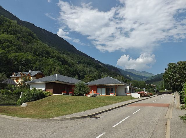
Montgellafrey (Montgellafrey)

- former commune in Savoie, France
 Hiking in Montgellafrey
Montgellafrey, located in the French Alps, is a beautiful destination for hikers looking to explore stunning mountain landscapes and enjoy outdoor activities. Situated near the Vanoise National Park, this area offers a variety of trails suited for different skill levels, making it an attractive spot for both beginners and experienced hikers.
Key Highlights of Hiking in Montgellafrey:
-
Diverse Trails: Montgellafrey offers various hiking trails, ranging from easy strolls to challenging ascents. The routes often provide panoramic views of the surrounding mountains and valleys.
-
Flora and Fauna: The region is rich in biodiversity, with opportunities to observe local wildlife, including ibex, chamois, and various bird species. The alpine meadows are also filled with colorful wildflowers, particularly in late spring and early summer.
-
Vanoise National Park: Being close to this national park, hikers can access many well-marked trails that explore its stunning landscapes, glaciers, and picturesque lakes. The park is recognized for its natural beauty and ecological significance.
-
Cultural Heritage: Hiking in the area allows you to experience local culture. You might come across traditional Alpine villages, historic chalets, and regional cuisine, enhancing your overall experience.
-
Seasons: The best time to hike in Montgellafrey is typically during late spring to early autumn (from May to September), when the trails are generally clear of snow, and the weather is more favorable for outdoor activities.
-
Safety Considerations: Always check the weather conditions before heading out and prepare adequately. Carry enough water, snacks, and a map or GPS device. If you're hiking in more remote areas, it’s wise to inform someone about your plans.
Popular Hiking Routes:
- Col de Montgellafrey: An accessible hike that rewards with stunning views without excessive difficulty.
- Lac de la Partie: This route leads to a picturesque mountain lake, ideal for a leisurely day hike.
- Vanoise High Trail: For experienced hikers, this longer trail offers breathtaking views and a chance to explore more remote areas of the national park.
Additional Tips:
- Guided Tours: If you're unfamiliar with the area or new to hiking, consider joining a guided tour. Local guides can enhance your experience with their knowledge of the terrain and wildlife.
- Accommodations: Look for mountain huts or lodges in the region for an authentic Alpine experience. Many have local specialties on their menu and provide a cozy place to relax after a day of hiking.
Montgellafrey is a fantastic choice for a hiking adventure. Whether you're trekking for the views, the wildlife, or the quiet of nature, this beautiful alpine region has plenty to offer.
- Country:

- Postal Code: 73130
- Coordinates: 45° 23' 32" N, 6° 19' 7" E


- GPS tracks (wikiloc): [Link]
- Area: 19.36 sq km
- Population: 65
- Wikipedia en: wiki(en)
- Wikipedia: wiki(fr)
- Wikidata storage: Wikidata: Q1217239
- Wikipedia Commons Category: [Link]
- Freebase ID: [/m/03npf94]
- GeoNames ID: Alt: [6442829]
- BnF ID: [15274099h]
- INSEE municipality code: 73167
Shares border with regions:


Épierre
- commune in Savoie, France
Hiking in Épierre
Épierre is a charming commune nestled in the Savoie region of the French Alps, renowned for its stunning natural landscapes and outdoor activities, including hiking. The area is characterized by mountainous terrain, lush forests, and picturesque views, making it a wonderful destination for hikers of all levels....
- Country:
- Postal Code: 73220
- Coordinates: 45° 27' 14" N, 6° 17' 41" E
- GPS tracks (wikiloc): [Link]
- AboveSeaLevel: 348 м m
- Area: 19.36 sq km
- Population: 770
- Web site: [Link]


Les Chavannes-en-Maurienne
- commune in Savoie, France
Hiking in Les Chavannes-en-Maurienne
Les Chavannes-en-Maurienne is a delightful destination for hiking enthusiasts, nestled in the Maurienne Valley in the French Alps. This picturesque village offers a range of hiking opportunities, catering to all skill levels. Here are some highlights:...
- Country:
- Postal Code: 73660
- Coordinates: 45° 23' 29" N, 6° 16' 55" E
- GPS tracks (wikiloc): [Link]
- Area: 4.69 sq km
- Population: 255


Saint-Martin-sur-la-Chambre
- commune in Savoie, France
Hiking in Saint-Martin-sur-la-Chambre
Saint-Martin-sur-la-Chambre is a beautiful village located in the Savoie department in the Auvergne-Rhône-Alpes region of southeastern France. It's nestled in the Alps, making it an excellent destination for hiking enthusiasts. Here are some highlights of hiking in this area:...
- Country:
- Postal Code: 73130
- Coordinates: 45° 21' 55" N, 6° 19' 0" E
- GPS tracks (wikiloc): [Link]
- Area: 4.69 sq km
- Population: 541
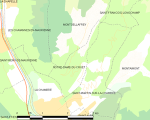
Notre-Dame-du-Cruet
- commune in Savoie, France
Hiking in Notre-Dame-du-Cruet
Notre-Dame-du-Cruet is a charming commune located in the Savoie department in the Auvergne-Rhône-Alpes region of France. It's surrounded by stunning natural landscapes, making it an excellent spot for hiking enthusiasts. Here are some insights about hiking in and around Notre-Dame-du-Cruet:...
- Country:
- Postal Code: 73130
- Coordinates: 45° 22' 13" N, 6° 18' 41" E
- GPS tracks (wikiloc): [Link]
- Area: 1.9 sq km
- Population: 223


La Léchère
- commune in Savoie, France
Hiking in La Léchère
La Léchère, located in the French Alps, is a beautiful destination for hiking enthusiasts. The region is known for its stunning landscapes, which include alpine meadows, serene lakes, and striking mountain peaks. Here are some highlights and tips for hiking in La Léchère:...
- Country:
- Postal Code: 73260
- Coordinates: 45° 31' 56" N, 6° 28' 24" E
- GPS tracks (wikiloc): [Link]
- Area: 134.54 sq km
- Population: 1823

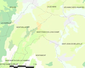
Saint-François-Longchamp
- former commune in Savoie, France until 2016, now delegated commune
Hiking in Saint-François-Longchamp
Saint-François-Longchamp is a beautiful alpine resort located in the French Alps, known primarily for its skiing in the winter but also offers a multitude of hiking opportunities during the summer months. Here are some key points about hiking in this area:...
- Country:
- Postal Code: 73130
- Coordinates: 45° 24' 35" N, 6° 20' 54" E
- GPS tracks (wikiloc): [Link]
- Area: 12.97 sq km
- Population: 247
- Web site: [Link]
La Chapelle, Savoie
- commune in Savoie, France
Hiking in La Chapelle, Savoie
La Chapelle, located in the Savoie region of the French Alps, is a picturesque village that serves as a great base for hiking enthusiasts. The area is known for its stunning alpine scenery, offering a variety of trails suitable for all levels of hikers, from beginners to experienced trekkers....
- Country:
- Postal Code: 73660
- Coordinates: 45° 25' 8" N, 6° 16' 41" E
- GPS tracks (wikiloc): [Link]
- Area: 12.28 sq km
- Population: 339