.jpg)
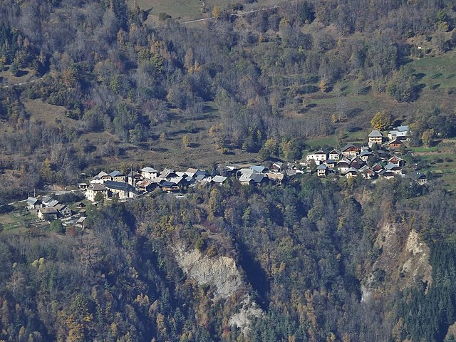
Saint-François-Longchamp (Saint-François-Longchamp)

- former commune in Savoie, France until 2016, now delegated commune
 Hiking in Saint-François-Longchamp
Saint-François-Longchamp is a beautiful alpine resort located in the French Alps, known primarily for its skiing in the winter but also offers a multitude of hiking opportunities during the summer months. Here are some key points about hiking in this area:
Trails and Routes
-
Diverse Terrain: The region boasts a variety of trails suitable for different skill levels, from gentle walks perfect for families to challenging hikes for experienced trekkers.
-
Popular Hikes:
- Les Cimes de la Lauzière: A rewarding hike that offers stunning panoramic views of the surrounding mountains, including Mont Blanc on clear days.
- Lac de la Rosière: A relatively easy hike that leads to a picturesque lake, perfect for a relaxing picnic break while enjoying the natural beauty.
- Sentier des Cascades: This trail features beautiful waterfalls and is ideal for those looking for a scenic, less strenuous option.
-
Guided Hikes: For those unfamiliar with the area or preferring companionship, guided hikes are available. Local guides can provide insight into the flora and fauna of the region as well as historical context.
Seasonal Considerations
- Best Time to Hike: The prime hiking season is typically from late spring to early autumn (June to September), when trails are clear of snow, and the weather is generally stable.
- Weather: Alpine weather can be unpredictable; it's important to check forecasts and be prepared for changing conditions.
Preparations
- Gear: Ensure you have appropriate hiking gear, including sturdy shoes, weather-appropriate clothing, and a good backpack. Don't forget essentials like water, snacks, and a map or GPS device.
- Safety: Always inform someone about your hiking plans, especially if venturing into less populated areas. Carry a first-aid kit and know basic treatment for injuries.
Additional Activities
- When not hiking, you can enjoy other activities such as mountain biking, paragliding, and trail running. The area also has several viewpoints and picnic spots for those wishing to soak in the beauty without a rigorous hike.
Accessibility
- Saint-François-Longchamp is accessible by car and public transport, with parking available for those driving. The trails are interconnected, allowing for flexible hiking routes depending on your interests and fitness levels.
Hiking in Saint-François-Longchamp offers a wonderful way to experience the stunning landscapes, rich biodiversity, and serene atmosphere of the French Alps. Enjoy your adventure!
- Country:

- Postal Code: 73130
- Coordinates: 45° 24' 35" N, 6° 20' 54" E


- GPS tracks (wikiloc): [Link]
- Area: 12.97 sq km
- Population: 247
- Web site: http://www.saintfrancoislongchamp.com/
- Wikipedia en: wiki(en)
- Wikipedia: wiki(fr)
- Wikidata storage: Wikidata: Q652398
- Wikipedia Commons Category: [Link]
- Freebase ID: [/m/03npgkg]
- SIREN number: [200072270]
- BnF ID: [15274166t]
- INSEE municipality code: 73235
Shares border with regions:


Montaimont
- former commune in Savoie, France
Hiking in Montaimont
Montaimont is a charming commune in the Savoie department of the Auvergne-Rhône-Alpes region in southeastern France. Nestled in the Alps, it offers stunning natural landscapes and a variety of hiking opportunities, making it an excellent destination for outdoor enthusiasts....
- Country:
- Postal Code: 73130
- Coordinates: 45° 22' 17" N, 6° 20' 49" E
- GPS tracks (wikiloc): [Link]
- Area: 28.35 sq km
- Population: 157
- Web site: [Link]

Montgellafrey
- former commune in Savoie, France
Hiking in Montgellafrey
Montgellafrey, located in the French Alps, is a beautiful destination for hikers looking to explore stunning mountain landscapes and enjoy outdoor activities. Situated near the Vanoise National Park, this area offers a variety of trails suited for different skill levels, making it an attractive spot for both beginners and experienced hikers....
- Country:
- Postal Code: 73130
- Coordinates: 45° 23' 32" N, 6° 19' 7" E
- GPS tracks (wikiloc): [Link]
- Area: 19.36 sq km
- Population: 65


Saint-Martin-sur-la-Chambre
- commune in Savoie, France
Hiking in Saint-Martin-sur-la-Chambre
Saint-Martin-sur-la-Chambre is a beautiful village located in the Savoie department in the Auvergne-Rhône-Alpes region of southeastern France. It's nestled in the Alps, making it an excellent destination for hiking enthusiasts. Here are some highlights of hiking in this area:...
- Country:
- Postal Code: 73130
- Coordinates: 45° 21' 55" N, 6° 19' 0" E
- GPS tracks (wikiloc): [Link]
- Area: 4.69 sq km
- Population: 541


La Léchère
- commune in Savoie, France
Hiking in La Léchère
La Léchère, located in the French Alps, is a beautiful destination for hiking enthusiasts. The region is known for its stunning landscapes, which include alpine meadows, serene lakes, and striking mountain peaks. Here are some highlights and tips for hiking in La Léchère:...
- Country:
- Postal Code: 73260
- Coordinates: 45° 31' 56" N, 6° 28' 24" E
- GPS tracks (wikiloc): [Link]
- Area: 134.54 sq km
- Population: 1823


Les Avanchers-Valmorel
- commune in Savoie, France
Hiking in Les Avanchers-Valmorel
Les Avanchers-Valmorel is a picturesque destination in the French Alps that attracts hikers with its stunning landscapes, diverse trails, and a range of outdoor activities. Situated in the Savoie region, this area is known for its beautiful mountain scenery, charming alpine villages, and a rich natural environment....
- Country:
- Postal Code: 73260
- Coordinates: 45° 28' 39" N, 6° 27' 22" E
- GPS tracks (wikiloc): [Link]
- Area: 21.93 sq km
- Population: 766
- Web site: [Link]

Saint-Jean-de-Belleville
- commune in Savoie, France
Hiking in Saint-Jean-de-Belleville
Saint-Jean-de-Belleville is a charming alpine village located in the Savoie region of the French Alps, offering beautiful landscapes and a variety of hiking opportunities. Situated near the Trois Vallées ski area, it serves as a fantastic base for exploring the surrounding mountains, particularly in the warmer months when the snow melts and trails become accessible....
- Country:
- Postal Code: 73440
- Coordinates: 45° 25' 37" N, 6° 29' 6" E
- GPS tracks (wikiloc): [Link]
- Area: 59.6 sq km
- Population: 535
- Web site: [Link]