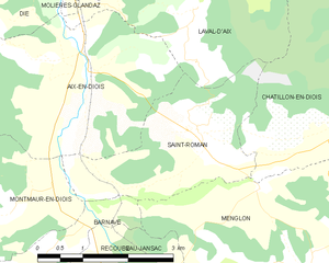
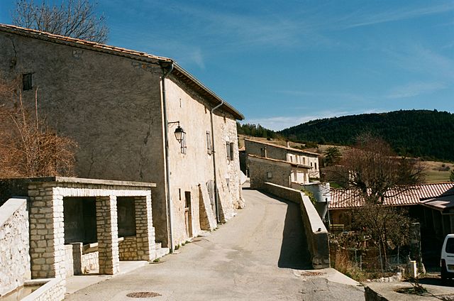
Montmaur-en-Diois (Montmaur-en-Diois)

- commune in Drôme, France
 Hiking in Montmaur-en-Diois
Montmaur-en-Diois is a picturesque village located in the Drôme department of southeastern France. It is nestled in the Diois region, which is known for its stunning natural landscapes, including rolling hills, limestone cliffs, and lush valleys. Hiking in this area offers a fantastic way to explore the beautiful scenery and enjoy a range of outdoor activities.
Hiking Opportunities
-
Diverse Trails: The Montmaur-en-Diois area features a variety of hiking trails that cater to different skill levels. You can find easy walks suitable for families as well as more challenging routes for experienced hikers.
-
Scenic Views: Many trails provide breathtaking views of the surrounding mountains and valleys. The dramatic landscapes are perfect for photographers and nature lovers alike.
-
Flora and Fauna: The Diois region is rich in biodiversity, with many opportunities to observe local wildlife and plant species. Keep an eye out for endemic plants and various bird species during your hike.
-
Cultural Souvenirs: Some trails may lead you through charming villages or past historical sites, allowing hikers to experience the rich culture of the region while enjoying their outdoor adventure.
-
Nearby Attractions: After a day of hiking, you might want to explore nearby attractions such as the Cévennes National Park, which offers additional trails and natural beauty, or the charming town of Die, known for its history and local produce.
Practical Tips
- Trail Information: Always check local guides or maps for up-to-date information about trail conditions and difficulty levels.
- Weather Preparedness: The weather can change quickly in mountainous areas. Dress in layers and prepare for potential rain or temperature drops.
- Safety Precautions: Make sure to bring sufficient water, snacks, and a first-aid kit. It's also advisable to inform someone about your hiking plans before heading out.
- Respect Nature: Stay on marked trails, carry out what you bring in, and respect the local wildlife and flora.
Whether you're looking for a peaceful day hike or a more rigorous trek, Montmaur-en-Diois has something to offer for every hiking enthusiast. Enjoy your adventure and the stunning beauty of this region!
- Country:

- Postal Code: 26150
- Coordinates: 44° 40' 35" N, 5° 22' 46" E


- GPS tracks (wikiloc): [Link]
- Area: 12.8 sq km
- Population: 80
- Wikipedia en: wiki(en)
- Wikipedia: wiki(fr)
- Wikidata storage: Wikidata: Q633437
- Wikipedia Commons Category: [Link]
- Wikipedia Commons Maps Category: [Link]
- Freebase ID: [/m/03mgjwg]
- GeoNames ID: Alt: [2992262]
- SIREN number: [212602056]
- BnF ID: [15253066w]
- INSEE municipality code: 26205
Shares border with regions:


Barnave
- commune in Drôme, France
Hiking in Barnave
Barnave is a small village located in the Drôme department in the Auvergne-Rhône-Alpes region of southeastern France. The area is known for its stunning natural landscapes, making it an excellent destination for hiking enthusiasts. Here are some highlights about hiking in and around Barnave:...
- Country:
- Postal Code: 26310
- Coordinates: 44° 39' 36" N, 5° 22' 12" E
- GPS tracks (wikiloc): [Link]
- Area: 13.06 sq km
- Population: 185

Saint-Roman
- commune in Drôme, France
Hiking in Saint-Roman
Saint-Roman is a charming commune located in the Drôme department of southeastern France, known for its beautiful natural landscapes and outdoor activities. Hiking in this region offers a unique experience, with varying terrains and stunning views of the surrounding mountains and valleys....
- Country:
- Postal Code: 26410
- Coordinates: 44° 41' 29" N, 5° 25' 58" E
- GPS tracks (wikiloc): [Link]
- Area: 7.1 sq km
- Population: 178
- Web site: [Link]


Aurel
- commune in Drôme, France
Hiking in Aurel
Aurel, located in the Drôme department in the Auvergne-Rhône-Alpes region of southeastern France, is a charming village surrounded by beautiful natural landscapes, making it an ideal destination for hiking enthusiasts. The area boasts a blend of rolling hills, picturesque vineyards, and stunning views of the surrounding mountains, particularly the Vercors Massif....
- Country:
- Postal Code: 26340
- Coordinates: 44° 41' 44" N, 5° 17' 56" E
- GPS tracks (wikiloc): [Link]
- Area: 26.26 sq km
- Population: 239

Rimon-et-Savel
- commune in Drôme, France
Hiking in Rimon-et-Savel
Rimon-et-Savel is a beautiful commune located in the Drôme department in the Auvergne-Rhône-Alpes region of southeastern France. It's known for its picturesque landscapes and outdoor activities, making it a great destination for hiking enthusiasts....
- Country:
- Postal Code: 26340
- Coordinates: 44° 39' 48" N, 5° 18' 27" E
- GPS tracks (wikiloc): [Link]
- Area: 12.31 sq km
- Population: 29