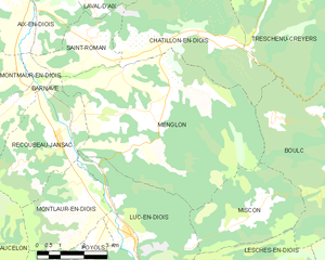
Saint-Roman (Saint-Roman)

- commune in Drôme, France
 Hiking in Saint-Roman
Saint-Roman is a charming commune located in the Drôme department of southeastern France, known for its beautiful natural landscapes and outdoor activities. Hiking in this region offers a unique experience, with varying terrains and stunning views of the surrounding mountains and valleys.
Hiking Trails:
-
Local Routes: There are several marked hiking trails around Saint-Roman suitable for different skill levels. These trails often wind through forests, past vineyards, and alongside rivers, providing a mix of natural beauty and cultural heritage.
-
Nearby National Parks: Depending on how far you're willing to travel, the Vercors Regional Natural Park and the Parc Naturel Régional des Baronnies Provençales are within reach. These parks offer an extensive network of trails ranging from easy walks to challenging hikes with breathtaking panoramas.
-
GR Trails: The Grande Randonnée (GR) routes in the area can take you through diverse landscapes, from limestone cliffs to lush greenery. The GR93 is one route that passes through this part of the Drôme, connecting various regional attractions.
Best Times to Go:
- Spring and Fall: These seasons feature mild weather and fewer crowds, making them ideal for hiking. The landscapes are vibrant with blooming flowers in spring and colorful foliage in autumn.
- Summer: While it can be warm, early morning hikes can provide a cooler experience, and the longer days allow for extended exploration.
- Winter: Some trails may be snow-covered, making them suitable for snowshoeing or winter hikes in certain areas.
Tips for Hiking in Saint-Roman:
- Know Your Limits: Choose trails that match your fitness level and experience.
- Prepare for Weather: Check the forecast and dress in layers, as temperatures can vary greatly, especially in mountainous areas.
- Stay Hydrated and Nourished: Carry enough water and energy snacks, particularly on longer hikes.
- Respect Nature: Follow the Leave No Trace principles to preserve the beautiful landscape.
- Navigation: While trails may be marked, having a map or GPS device can be helpful for route planning.
Conclusion:
Hiking in and around Saint-Roman provides a wonderful opportunity to connect with nature and experience the unspoiled beauty of the French countryside. Whether you’re looking for a leisurely stroll or an adventurous trek, the region offers a wide range of options. Enjoy your hike, and don’t forget your camera to capture the stunning views!
- Country:

- Postal Code: 26410
- Coordinates: 44° 41' 29" N, 5° 25' 58" E


- GPS tracks (wikiloc): [Link]
- Area: 7.1 sq km
- Population: 178
- Web site: http://www.saint-roman.fr/
- Wikipedia en: wiki(en)
- Wikipedia: wiki(fr)
- Wikidata storage: Wikidata: Q219553
- Wikipedia Commons Category: [Link]
- Freebase ID: [/m/03mhl0r]
- GeoNames ID: Alt: [6430235]
- SIREN number: [212603278]
- BnF ID: [152531874]
- INSEE municipality code: 26327
Shares border with regions:

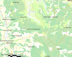
Menglon
- commune in Drôme, France
Hiking in Menglon
Menglon is a picturesque village located in the Drôme department of southeastern France, known for its proximity to the stunning Vercors Regional Natural Park. This area offers a variety of hiking opportunities suitable for different skill levels, making it a great destination for outdoor enthusiasts....
- Country:
- Postal Code: 26410
- Coordinates: 44° 39' 51" N, 5° 27' 44" E
- GPS tracks (wikiloc): [Link]
- Area: 36.47 sq km
- Population: 485


Barnave
- commune in Drôme, France
Hiking in Barnave
Barnave is a small village located in the Drôme department in the Auvergne-Rhône-Alpes region of southeastern France. The area is known for its stunning natural landscapes, making it an excellent destination for hiking enthusiasts. Here are some highlights about hiking in and around Barnave:...
- Country:
- Postal Code: 26310
- Coordinates: 44° 39' 36" N, 5° 22' 12" E
- GPS tracks (wikiloc): [Link]
- Area: 13.06 sq km
- Population: 185


Laval-d'Aix
- commune in Drôme, France
Hiking in Laval-d'Aix
Laval-d'Aix, located in the Auvergne-Rhône-Alpes region of France, offers stunning scenic beauty and a variety of hiking opportunities. Here are some key points to consider:...
- Country:
- Postal Code: 26150
- Coordinates: 44° 42' 48" N, 5° 25' 53" E
- GPS tracks (wikiloc): [Link]
- Area: 20.05 sq km
- Population: 124

Châtillon-en-Diois
- commune in Drôme, France
Hiking in Châtillon-en-Diois
Châtillon-en-Diois is a picturesque commune located in the Drôme department of France, nestled in the foothills of the Vercors Mountains. It is a great destination for hiking, offering a variety of trails that cater to different skill levels and preferences. Here are some highlights about hiking in and around this beautiful area:...
- Country:
- Postal Code: 26410
- Coordinates: 44° 41' 41" N, 5° 29' 3" E
- GPS tracks (wikiloc): [Link]
- Area: 28.02 sq km
- Population: 555
- Web site: [Link]


Montmaur-en-Diois
- commune in Drôme, France
Hiking in Montmaur-en-Diois
Montmaur-en-Diois is a picturesque village located in the Drôme department of southeastern France. It is nestled in the Diois region, which is known for its stunning natural landscapes, including rolling hills, limestone cliffs, and lush valleys. Hiking in this area offers a fantastic way to explore the beautiful scenery and enjoy a range of outdoor activities....
- Country:
- Postal Code: 26150
- Coordinates: 44° 40' 35" N, 5° 22' 46" E
- GPS tracks (wikiloc): [Link]
- Area: 12.8 sq km
- Population: 80