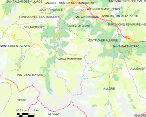
Montricher-Albanne (Montricher-Albanne)

- commune in Savoie, France
 Hiking in Montricher-Albanne
Montricher-Albanne is a picturesque village located in the French Alps, within the Savoie region. It is an excellent destination for hiking enthusiasts due to its stunning natural landscapes, a variety of trails, and the breathtaking views of the surrounding mountain ranges.
Hiking Trails
-
Trail Variety: The area offers a range of hiking trails suitable for all levels, from easy walks for beginners to more challenging hikes for experienced hikers. Many paths are well-marked, allowing for a safe and enjoyable experience.
-
Scenic Views: Hikes often lead to panoramic viewpoints where you can witness the beauty of the Alps, including views of nearby peaks, valleys, and forests. The changing seasons bring different landscapes, making it appealing year-round.
-
Flora and Fauna: The region is rich in biodiversity, featuring a variety of alpine flora and wildlife. Keep an eye out for local species, especially during the spring and summer months when wildflowers bloom.
Popular Hiking Routes
-
Mont Thabor: A more challenging hike that offers incredible views from the summit. This trek typically requires a full day to complete and is recommended for experienced hikers.
-
Lacs des Cerces: This moderate hike leads to beautiful glacial lakes and is perfect for those looking to enjoy a day in nature with opportunities for picnicking and photography.
-
Cime de la Valette: An easier trail that is accessible for families and beginners, it provides lovely views of the valley and is great for a half-day outing.
Best Time to Hike
-
Summer (June to September): The most popular time for hiking. The weather is generally warm and trails are clear of snow.
-
Autumn (October): Can offer spectacular fall colors, but be mindful of cooler temperatures and shorter days.
-
Winter (December to March): While traditional hiking may be hampered by snow, winter hiking or snowshoeing can be a thrilling alternative.
Preparation
-
Gear: Ensure you have appropriate hiking gear including sturdy footwear, weather-appropriate clothing, and sufficient water and snacks. A basic first-aid kit is also recommended.
-
Navigation: Although trails are often marked, a map and compass or GPS device can be beneficial, especially for less-traveled routes.
Local Amenities
Montricher-Albanne may have basic amenities for hikers, including accommodations, local shops, and eateries. Consider checking for local hiking groups or guides if you prefer a guided experience.
In summary, Montricher-Albanne is a wonderful destination for hiking, offering an array of trails and stunning alpine scenery. Whether you are a seasoned hiker or a beginner, the area provides numerous opportunities to explore and enjoy the great outdoors. Always remember to follow local guidelines and practice Leave No Trace principles to preserve the natural beauty of this region.
- Country:

- Postal Code: 73870
- Coordinates: 45° 14' 48" N, 6° 24' 9" E


- GPS tracks (wikiloc): [Link]
- Area: 27.99 sq km
- Population: 477
- Wikipedia en: wiki(en)
- Wikipedia: wiki(fr)
- Wikidata storage: Wikidata: Q544253
- Wikipedia Commons Category: [Link]
- Freebase ID: [/m/03npf4t]
- GeoNames ID: Alt: [6617582]
- SIREN number: [217301738]
- BnF ID: [15274105m]
- VIAF ID: Alt: [241581656]
- INSEE municipality code: 73173
Shares border with regions:

Albiez-Montrond
- commune in Savoie, France
Hiking in Albiez-Montrond
Albiez-Montrond is a charming alpine village located in the Savoie region of the French Alps, known for its stunning mountain scenery and outdoor activities, including hiking. Here are some details about hiking in this beautiful area:...
- Country:
- Postal Code: 73300
- Coordinates: 45° 13' 11" N, 6° 20' 27" E
- GPS tracks (wikiloc): [Link]
- Area: 48.58 sq km
- Population: 382
- Web site: [Link]

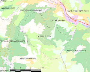
Albiez-le-Jeune
- commune in Savoie, France
Hiking in Albiez-le-Jeune
Albiez-le-Jeune is a charming village located in the French Alps, specifically in the Savoie department. This area is perfect for hiking enthusiasts due to its stunning natural landscapes, diverse trails, and mountainous terrain....
- Country:
- Postal Code: 73300
- Coordinates: 45° 14' 42" N, 6° 21' 6" E
- GPS tracks (wikiloc): [Link]
- Area: 12.45 sq km
- Population: 146


Saint-Julien-Mont-Denis
- commune in Savoie, France
Hiking in Saint-Julien-Mont-Denis
Saint-Julien-Mont-Denis is a picturesque village located in the Savoie region of the French Alps, offering a variety of hiking opportunities for all skill levels. Nestled against a backdrop of stunning mountains, the area is popular among outdoor enthusiasts, particularly during the warmer months....
- Country:
- Postal Code: 73870
- Coordinates: 45° 15' 23" N, 6° 24' 16" E
- GPS tracks (wikiloc): [Link]
- Area: 33.04 sq km
- Population: 1629
- Web site: [Link]
Saint-Martin-de-la-Porte
- commune in Savoie, France
Hiking in Saint-Martin-de-la-Porte
Saint-Martin-de-la-Porte is a charming commune in the Savoie department of the Auvergne-Rhône-Alpes region in southeastern France, nestled in the beautiful Alps. The area offers stunning natural landscapes, making it an excellent destination for hiking enthusiasts....
- Country:
- Postal Code: 73140
- Coordinates: 45° 14' 24" N, 6° 26' 46" E
- GPS tracks (wikiloc): [Link]
- Area: 19.25 sq km
- Population: 686


Villargondran
- commune in Savoie, France
Hiking in Villargondran
Villargondran is a small village located in the Savoie region of the French Alps, near the larger town of Albertville. It offers a beautiful setting for hiking enthusiasts, with stunning mountain landscapes, lush forests, and a variety of trails suitable for different skill levels....
- Country:
- Postal Code: 73300
- Coordinates: 45° 15' 39" N, 6° 22' 27" E
- GPS tracks (wikiloc): [Link]
- Area: 6.12 sq km
- Population: 873


Valloire
- commune in Savoie, France
Hiking in Valloire
Valloire is a charming mountain village located in the Savoie region of the French Alps. It's known for its stunning landscapes, rich heritage, and excellent opportunities for hiking and outdoor activities. Here are some highlights of hiking in Valloire:...
- Country:
- Postal Code: 73450
- Coordinates: 45° 9' 55" N, 6° 25' 42" E
- GPS tracks (wikiloc): [Link]
- Area: 137.48 sq km
- Population: 1135
- Web site: [Link]