Valloire (Valloire)

- commune in Savoie, France
 Hiking in Valloire
Valloire is a charming mountain village located in the Savoie region of the French Alps. It's known for its stunning landscapes, rich heritage, and excellent opportunities for hiking and outdoor activities. Here are some highlights of hiking in Valloire:
Trails and Routes
-
Varied Difficulty Levels: Valloire offers a range of hiking trails suitable for all levels, from easy walks suitable for families to more challenging alpine routes.
-
Alpine Scenery: Many trails boast breathtaking views of the surrounding peaks, including the famous Galibier mountain. The landscapes feature lush valleys, rugged mountains, and beautiful alpine flora.
-
Notable Hikes:
- Col du Galibier: A popular route that takes hikers through stunning alpine scenery. It's also a historically significant pass known for its cycling routes.
- Les Aiguilles d'Arves: A more challenging hike that offers stunning views and the chance to experience the rugged beauty of the Alps.
- Lake of Les Cerces: An easier option, this hike offers picturesque views and is suitable for families or those seeking a leisurely trek.
Best Time to Hike
- Summer (June to September): This is the prime hiking season with the most accessible trails. The weather is generally mild, making it ideal for exploring.
- Autumn (September to October): Another great option, with fewer crowds and beautiful autumn colors.
Tips for Hiking in Valloire
- Check Trail Conditions: Always check current trail conditions and weather forecasts. Mountain weather can change quickly.
- Start Early: If you're planning a longer hike, start early to avoid afternoon storms and ensure plenty of daylight.
- Stay Hydrated and Nourished: Carry enough water and snacks to keep your energy up during your hikes.
- Safety Gear: Depending on the difficulty of your hike, consider wearing sturdy hiking boots, and have basic safety and navigation gear, including a map or GPS.
Local Guides and Resources
There are local hiking guides and organized tours available that can enhance your experience. They can provide insights into the flora, fauna, and history of the region.
Additional Activities
Besides hiking, Valloire offers activities such as mountain biking, paragliding, and winter sports in the colder months, making it a versatile destination for outdoor enthusiasts year-round.
In summary, Valloire is a fantastic destination for hiking, with trails that cater to various skill levels and the opportunity to enjoy the stunning natural beauty of the French Alps.
- Country:

- Postal Code: 73450
- Coordinates: 45° 9' 55" N, 6° 25' 42" E


- GPS tracks (wikiloc): [Link]
- Area: 137.48 sq km
- Population: 1135
- Web site: http://www.valloire.net
- Wikipedia en: wiki(en)
- Wikipedia: wiki(fr)
- Wikidata storage: Wikidata: Q819204
- Wikipedia Commons Category: [Link]
- Freebase ID: [/m/03gtmfd]
- GeoNames ID: Alt: [2970899]
- SIREN number: [217303064]
- BnF ID: [152742365]
- VIAF ID: Alt: [167675063]
- INSEE municipality code: 73306
Shares border with regions:
Le Monêtier-les-Bains
- commune in Hautes-Alpes, France
Hiking in Le Monêtier-les-Bains
Le Monêtier-les-Bains, located in the Hautes-Alpes region of France, is a stunning destination for hiking enthusiasts. Nestled in the Serre Chevalier Valley, this alpine village offers a variety of trails that cater to all levels of hikers, from beginners to experienced adventurers. Here are some highlights and tips for hiking in Le Monêtier-les-Bains:...
- Country:
- Postal Code: 05220
- Coordinates: 44° 58' 34" N, 6° 30' 31" E
- GPS tracks (wikiloc): [Link]
- Area: 97.87 sq km
- Population: 1024
- Web site: [Link]


Saint-Jean-d'Arves
- commune in Savoie, France
Hiking in Saint-Jean-d'Arves
Saint-Jean-d'Arves is a picturesque village located in the French Alps, specifically in the Savoie region. This area is renowned for its stunning mountain landscapes, diverse wildlife, and a wide array of hiking opportunities. Here’s what you can expect when hiking in Saint-Jean-d'Arves:...
- Country:
- Postal Code: 73530
- Coordinates: 45° 12' 26" N, 6° 16' 23" E
- GPS tracks (wikiloc): [Link]
- Area: 75.6 sq km
- Population: 265
- Web site: [Link]

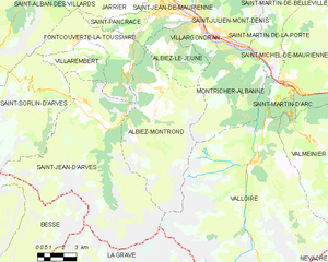
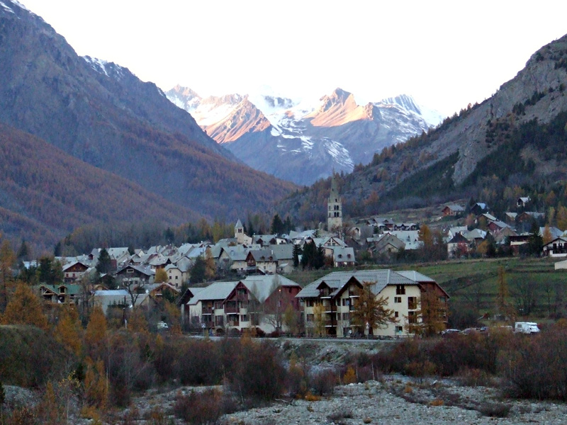
Albiez-Montrond
- commune in Savoie, France
Hiking in Albiez-Montrond
Albiez-Montrond is a charming alpine village located in the Savoie region of the French Alps, known for its stunning mountain scenery and outdoor activities, including hiking. Here are some details about hiking in this beautiful area:...
- Country:
- Postal Code: 73300
- Coordinates: 45° 13' 11" N, 6° 20' 27" E
- GPS tracks (wikiloc): [Link]
- Area: 48.58 sq km
- Population: 382
- Web site: [Link]


Saint-Martin-d'Arc
- commune in Savoie, France
Hiking in Saint-Martin-d'Arc
Saint-Martin-d'Arc is a charming village located in the French Alps, specifically in the Savoie department, which is known for its stunning landscapes and outdoor activities. Hiking in this area can be a fantastic experience, offering beautiful scenery, diverse trails, and a chance to connect with nature....
- Country:
- Postal Code: 73140
- Coordinates: 45° 12' 46" N, 6° 28' 5" E
- GPS tracks (wikiloc): [Link]
- Area: 4.93 sq km
- Population: 359


Montricher-Albanne
- commune in Savoie, France
Hiking in Montricher-Albanne
Montricher-Albanne is a picturesque village located in the French Alps, within the Savoie region. It is an excellent destination for hiking enthusiasts due to its stunning natural landscapes, a variety of trails, and the breathtaking views of the surrounding mountain ranges....
- Country:
- Postal Code: 73870
- Coordinates: 45° 14' 48" N, 6° 24' 9" E
- GPS tracks (wikiloc): [Link]
- Area: 27.99 sq km
- Population: 477

Névache
- commune in Hautes-Alpes, France
Hiking in Névache
Névache, located in the Hautes-Alpes region of France, is a beautiful destination for hiking enthusiasts. Nestled in the Écrins National Park, Névache is known for its stunning landscapes, including alpine meadows, rugged mountains, and crystal-clear rivers. Here are some highlights and tips for hiking in the area:...
- Country:
- Postal Code: 05100
- Coordinates: 45° 1' 7" N, 6° 36' 17" E
- GPS tracks (wikiloc): [Link]
- Area: 191.93 sq km
- Population: 359
- Web site: [Link]

La Grave
- commune in Hautes-Alpes, France
Hiking in La Grave
La Grave is a stunning area located in the French Alps, known for its breathtaking mountain scenery and varied hiking opportunities. Here are some key points to consider if you're planning a hiking trip in La Grave:...
- Country:
- Postal Code: 05320
- Coordinates: 45° 2' 46" N, 6° 18' 21" E
- GPS tracks (wikiloc): [Link]
- Area: 126.91 sq km
- Population: 487
- Web site: [Link]


Valmeinier
- commune in Savoie, France
Hiking in Valmeinier
Valmeinier is a charming mountain resort in the French Alps, located in the Savoie region. It's known for its stunning alpine scenery, making it a fantastic destination for hiking enthusiasts. Here’s what you need to know about hiking in Valmeinier:...
- Country:
- Postal Code: 73450
- Coordinates: 45° 11' 2" N, 6° 28' 54" E
- GPS tracks (wikiloc): [Link]
- Area: 54.26 sq km
- Population: 510
- Web site: [Link]
Saint-Martin-de-la-Porte
- commune in Savoie, France
Hiking in Saint-Martin-de-la-Porte
Saint-Martin-de-la-Porte is a charming commune in the Savoie department of the Auvergne-Rhône-Alpes region in southeastern France, nestled in the beautiful Alps. The area offers stunning natural landscapes, making it an excellent destination for hiking enthusiasts....
- Country:
- Postal Code: 73140
- Coordinates: 45° 14' 24" N, 6° 26' 46" E
- GPS tracks (wikiloc): [Link]
- Area: 19.25 sq km
- Population: 686