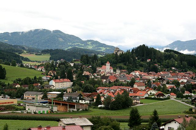
Murau District (Bezirk Murau)

- district of Austria
 Hiking in Murau District
Murau District, located in Styria, Austria, is a fantastic destination for hiking enthusiasts. Characterized by its stunning natural landscapes, lush forests, and picturesque alpine scenery, the area offers a variety of trails suitable for different skill levels, from gentle walks to challenging hikes.
Key Highlights of Hiking in Murau District:
-
Trails and Routes:
- Murauer Almenweg: This is a popular long-distance trail that takes you through several alpine pastures (Almen), with breathtaking views of the mountains and surrounding valleys. It spans about 100 kilometers, making it ideal for multi-day hiking trips.
- Kreischberg: The area around Kreischberg ski resort has numerous hiking trails in summer. You can enjoy splendid views and well-marked paths leading to scenic viewpoints.
- Nockberge National Park: While slightly outside the district, the trails in the nearby national park are worth exploring. You’ll find different paths leading to the unique karst landscapes and rich biodiversity of the region.
-
Scenic Beauty:
- The hiking trails offer diverse landscapes, from lush green meadows and dense forests to rugged mountain terrain. Expect to encounter beautiful alpine flowers, babbling brooks, and possibly even local wildlife, such as chamois or deer.
-
Culture and History:
- Hikers can also explore historical sites along the trails, including charming villages and cultural landmarks reflective of the region's rich history. Look for traditional farmhouses and ancient churches.
-
Accessibility:
- Many trails are easily accessible from the Murau town center, and public transport options are available for remote trailheads. The area is well-served by signage, making navigation straightforward for hikers.
-
Best Time to Hike:
- The prime hiking season in Murau generally runs from late spring through early autumn (May to October), when trail conditions are at their best and the weather is milder.
-
Guided Tours:
- For those looking for a more tailored experience, local hiking guides offer organized tours that can enhance your understanding of the region’s flora, fauna, and cultural history.
Before heading out, make sure to check local weather conditions and trail information, and always prepare appropriately with adequate gear, water, and snacks. Enjoy your hiking adventure in Murau District!
- Country:

- Licence Plate Code: MU
- Coordinates: 47° 7' 1" N, 14° 16' 59" E


- GPS tracks (wikiloc): [Link]
- AboveSeaLevel: 1510 м m
- Area: 1384 sq km
- Population: 28388
- Wikipedia en: wiki(en)
- Wikipedia: wiki(de)
- Wikidata storage: Wikidata: Q388913
- Wikipedia Commons Category: [Link]
- Freebase ID: [/m/0fnldm]
- GeoNames ID: Alt: [2771016]
- archINFORM location ID: [14697]
- Library of Congress authority ID: Alt: [n84091050]
- Theatricalia theatre ID: [2at]
Includes regions:
Sankt Lorenzen bei Scheifling
- former municipality in Austria
Hiking in Sankt Lorenzen bei Scheifling
Sankt Lorenzen bei Scheifling, located in the province of Styria in Austria, is a picturesque village that offers beautiful hiking opportunities in the stunning surrounding landscapes of the Austrian Alps. Here are some key highlights for hiking in this area:...
- Country:
- Local Dialing Code: 03582
- Licence Plate Code: MU
- Coordinates: 47° 8' 44" N, 14° 24' 21" E
- GPS tracks (wikiloc): [Link]
- AboveSeaLevel: 795 м m
- Area: 41.99 sq km
- Population: 635
Laßnitz bei Murau
- former municipality in Austria
Hiking in Laßnitz bei Murau
Laßnitz bei Murau is a picturesque region located in Styria, Austria, ideal for hiking enthusiasts. The area is surrounded by the beautiful Murau mountain ranges, offering a variety of trails suited for different skill levels, from leisurely walks to more challenging hikes....
- Country:
- Local Dialing Code: 0 35 32
- Licence Plate Code: MU
- Coordinates: 47° 4' 23" N, 14° 11' 42" E
- GPS tracks (wikiloc): [Link]
- AboveSeaLevel: 943 м m
- Area: 45.55 sq km
- Population: 1039

Krakau
- municipality in Austria
Hiking in Krakau
Kraków, while primarily known for its stunning historical architecture and vibrant culture, is also a gateway to some fantastic hiking opportunities in the surrounding areas. Here are some key points to consider if you're looking to hike near Kraków:...
- Country:
- Postal Code: 8854
- Local Dialing Code: 03535
- Licence Plate Code: MU
- Coordinates: 47° 10' 0" N, 14° 1' 0" E
- GPS tracks (wikiloc): [Link]
- AboveSeaLevel: 1173 м m
- Area: 123.6 sq km
- Population: 1419
- Web site: [Link]

Neumarkt in der Steiermark
- municipality in Austria
Hiking in Neumarkt in der Steiermark
Neumarkt in der Steiermark is a charming town located in Styria, Austria, surrounded by beautiful landscapes that offer various hiking opportunities. Here are some details that may help you explore hiking in this region:...
- Country:
- Postal Code: 8812, 8820, 8822, 9323, 9360
- Local Dialing Code: 03584
- Licence Plate Code: MU
- Coordinates: 47° 4' 15" N, 14° 25' 22" E
- GPS tracks (wikiloc): [Link]
- AboveSeaLevel: 847 м m
- Area: 163.52 sq km
- Population: 4963
- Web site: [Link]
Oberwölz
- municipality in Austria
Hiking in Oberwölz
Oberwölz is a quaint town located in the Styria region of Austria, surrounded by beautiful landscapes and numerous hiking opportunities. Here are some key points to consider if you’re planning to hike in and around Oberwölz:...
- Country:
- Postal Code: 8831, 8832
- Licence Plate Code: MU
- Coordinates: 47° 12' 10" N, 14° 16' 51" E
- GPS tracks (wikiloc): [Link]
- AboveSeaLevel: 830 м m
- Area: 210.17 sq km
- Population: 2960
- Web site: [Link]
Sankt Georgen am Kreischberg
- municipality in Austria
Hiking in Sankt Georgen am Kreischberg
Sankt Georgen am Kreischberg is a picturesque village located in the Austrian state of Styria, known for its stunning landscapes and outdoor activities, including hiking. The area offers a variety of trails that cater to different skill levels, from leisurely walks to challenging hikes....
- Country:
- Postal Code: 8850, 8861, 8862
- Licence Plate Code: MU
- Coordinates: 47° 6' 36" N, 14° 3' 0" E
- GPS tracks (wikiloc): [Link]
- AboveSeaLevel: 864 м m
- Area: 111.78 sq km
- Population: 1766
- Web site: [Link]
Stadl-Predlitz
- municipality in Austria
Hiking in Stadl-Predlitz
Stadl-Predlitz is a beautiful region located in the Austrian province of Styria, known for its stunning landscapes and numerous hiking opportunities. Nestled in the Eastern Alps, this area is famous for its natural beauty, including mountains, forests, and picturesque lakes....
- Country:
- Postal Code: 8862, 8863, 8864
- Local Dialing Code: 03534
- Licence Plate Code: MU
- Coordinates: 47° 5' 0" N, 13° 58' 0" E
- GPS tracks (wikiloc): [Link]
- AboveSeaLevel: 914 м m
- Area: 256.21 sq km
- Population: 1684
- Web site: [Link]
Teufenbach-Katsch
- municipality in Austria
Hiking in Teufenbach-Katsch
Teufenbach-Katsch, located in the scenic region of Styria, Austria, offers a variety of hiking opportunities for all skill levels amidst beautiful landscapes. The area is characterized by its lush forests, rolling hills, and stunning mountain views, making it a great destination for nature lovers and outdoor enthusiasts....
- Country:
- Postal Code: 8812, 8833, 8841, 8842, 8850
- Licence Plate Code: MU
- Coordinates: 47° 7' 43" N, 14° 21' 32" E
- GPS tracks (wikiloc): [Link]
- AboveSeaLevel: 760 м m
- Area: 42.27 sq km
- Population: 1899
- Web site: [Link]
Zeutschach
- former municipality in Austria
Hiking in Zeutschach
Zeutschach, located in Austria's Styria region, offers a picturesque backdrop for hiking enthusiasts. The area is characterized by lush forests, rolling hills, and scenic views of mountains, making it a great destination for both novice and experienced hikers....
- Country:
- Postal Code: 8820
- Local Dialing Code: 0 35 84
- Licence Plate Code: MU
- Coordinates: 47° 4' 15" N, 14° 22' 0" E
- GPS tracks (wikiloc): [Link]
- AboveSeaLevel: 1043 м m
- Area: 18.34 sq km
- Population: 210
Mariahof
- former municipality in Austria
Hiking in Mariahof
Mariahof, located in Austria, is a charming village nestled in the scenic landscapes of Styria. It's a great destination for hiking enthusiasts, offering a variety of trails that cater to different skill levels....
- Country:
- Local Dialing Code: 0 35 84
- Licence Plate Code: MU
- Coordinates: 47° 6' 0" N, 14° 24' 0" E
- GPS tracks (wikiloc): [Link]
- AboveSeaLevel: 963 м m
- Area: 32.7 sq km
- Population: 1225

Sankt Peter am Kammersberg
- municipality in Austria
Hiking in Sankt Peter am Kammersberg
Sankt Peter am Kammersberg is a picturesque village located in the Austrian state of Styria, known for its beautiful landscapes and access to outdoor activities, especially hiking. The region is characterized by its rolling hills, lush forests, and serene alpine meadows, making it an excellent destination for nature lovers....
- Country:
- Postal Code: 8843
- Local Dialing Code: 03536
- Licence Plate Code: MU
- Coordinates: 47° 11' 0" N, 14° 11' 0" E
- GPS tracks (wikiloc): [Link]
- AboveSeaLevel: 850 м m
- Area: 84.6 sq km
- Population: 2043
- Web site: [Link]
Oberwölz Umgebung
- former municipality in Austria
Hiking in Oberwölz Umgebung
Oberwölz Umgebung, located in the Styria region of Austria, offers a wonderful hiking experience for outdoor enthusiasts. This area is characterized by its stunning landscapes, including rolling hills, dense forests, and picturesque valleys, making it an ideal destination for hikers of all skill levels....
- Country:
- Local Dialing Code: 0 35 81
- Licence Plate Code: MU
- Coordinates: 47° 13' 0" N, 14° 17' 0" E
- GPS tracks (wikiloc): [Link]
- AboveSeaLevel: 1100 м m
- Area: 94.78 sq km
- Population: 780
Stadl an der Mur
- former municipality in Austria
Hiking in Stadl an der Mur
Stadl an der Mur is a charming village located in the scenic Murtal Valley of Austria, surrounded by stunning natural landscapes, making it a great destination for hiking enthusiasts. Here are some key points about hiking in this area:...
- Country:
- Postal Code: 8862
- Local Dialing Code: 03534
- Coordinates: 47° 5' 9" N, 13° 58' 45" E
- GPS tracks (wikiloc): [Link]
- AboveSeaLevel: 914 м m
- Area: 106.73 sq km
- Population: 957

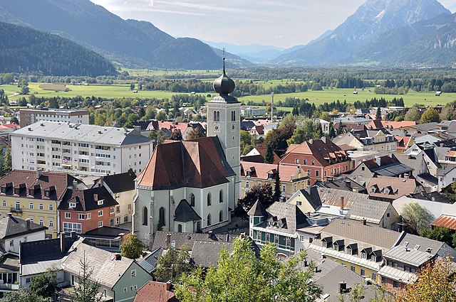
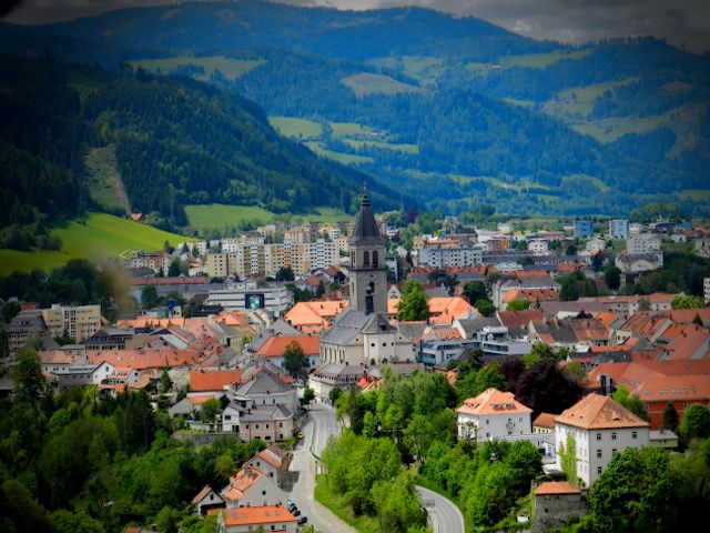
Murau
- municipality in Austria
Hiking in Murau
Murau, a picturesque town located in the Styria region of Austria, is surrounded by stunning natural landscapes, making it an excellent destination for hiking enthusiasts. Here’s an overview of what you can expect when hiking in and around Murau:...
- Country:
- Postal Code: 8850
- Local Dialing Code: 03532
- Licence Plate Code: MU
- Coordinates: 47° 6' 43" N, 14° 10' 23" E
- GPS tracks (wikiloc): [Link]
- AboveSeaLevel: 829 м m
- Area: 10.75 sq km
- Population: 3629
- Web site: [Link]
Triebendorf
- former municipality in Austria
Hiking in Triebendorf
Triebendorf is a beautiful area for hiking, located in the scenic region of Austria. Although it’s a relatively lesser-known destination, it offers stunning landscapes, charming trails, and a peaceful ambiance. Here are some highlights of hiking in Triebendorf:...
- Country:
- Local Dialing Code: 0 35 88
- Licence Plate Code: MU
- Coordinates: 47° 7' 46" N, 14° 14' 15" E
- GPS tracks (wikiloc): [Link]
- AboveSeaLevel: 824 м m
- Area: 8.52 sq km
- Population: 137
Kulm am Zirbitz
- former municipality in Austria
Hiking in Kulm am Zirbitz
Kulm am Zirbitz is a charming area located in the Styria region of Austria, known for its stunning landscapes and outdoor recreational opportunities. The area is situated near the Zirbitzkogel, which is the highest peak in the Seetal Alps, making it a great destination for hikers who want to experience the beauty of the Austrian mountains....
- Country:
- Local Dialing Code: 0 35 84
- Licence Plate Code: MU
- Coordinates: 47° 3' 0" N, 14° 28' 48" E
- GPS tracks (wikiloc): [Link]
- AboveSeaLevel: 1149 м m
- Area: 18.95 sq km
- Population: 304

Sankt Lambrecht
- municipality in Austria
Hiking in Sankt Lambrecht
Sankt Lambrecht, located in the scenic region of Styria, Austria, offers a variety of hiking opportunities for outdoor enthusiasts. This charming village is surrounded by the majestic mountains of the Niedere Tauern, providing a stunning backdrop for hikes ranging from leisurely walks to more challenging treks....
- Country:
- Postal Code: 8813
- Licence Plate Code: MU
- Coordinates: 47° 4' 0" N, 14° 18' 0" E
- GPS tracks (wikiloc): [Link]
- AboveSeaLevel: 1028 м m
- Area: 70.19 sq km
- Population: 1841
- Web site: [Link]

Oberwölz Stadt
- former municipality in Austria
Hiking in Oberwölz Stadt
Oberwölz Stadt, located in Styria, Austria, is a charming destination for hiking enthusiasts. Nestled in the scenic landscape of the Austrian Alps, it offers a variety of trails that cater to different skill levels, from leisurely walks to challenging hikes....
- Country:
- Local Dialing Code: 0 35 81
- Licence Plate Code: MU
- Coordinates: 47° 12' 10" N, 14° 16' 51" E
- GPS tracks (wikiloc): [Link]
- AboveSeaLevel: 830 м m
- Area: 4.64 sq km
- Population: 1001
Ranten
- municipality in Austria
Hiking in Ranten
Ranten, located in Austria, is a small village nestled in the natural beauty of the Styrian region, making it an excellent base for hiking enthusiasts. The area offers a variety of trails suitable for different skill levels, ranging from leisurely walks to more challenging hikes....
- Country:
- Postal Code: 8853
- Local Dialing Code: 03535
- Licence Plate Code: MU
- Coordinates: 47° 9' 24" N, 14° 3' 9" E
- GPS tracks (wikiloc): [Link]
- AboveSeaLevel: 997 м m
- Area: 38.79 sq km
- Population: 1161
- Web site: [Link]
Sankt Georgen ob Murau
- former municipality in Austria
Hiking in Sankt Georgen ob Murau
Sankt Georgen ob Murau is a beautiful destination located in the Austrian state of Styria, known for its stunning landscapes and charming countryside. The area offers various hiking opportunities suitable for different skill levels, making it an excellent choice for both beginners and experienced hikers....
- Country:
- Postal Code: 8861
- Local Dialing Code: 03537
- Licence Plate Code: MU
- Coordinates: 47° 6' 15" N, 14° 5' 56" E
- GPS tracks (wikiloc): [Link]
- AboveSeaLevel: 864 м m
- Area: 83.54 sq km
- Population: 1387
Schönberg-Lachtal
- former municipality in Austria
Hiking in Schönberg-Lachtal
Schönberg-Lachtal is a beautiful hiking destination located in Austria, specifically in the Eastern Alps. It is well-known for its stunning mountain scenery, diverse trails, and rich natural environment. Here are some key points to consider when hiking in Schönberg-Lachtal:...
- Country:
- Postal Code: 8831
- Licence Plate Code: MU
- Coordinates: 47° 11' 21" N, 14° 20' 46" E
- GPS tracks (wikiloc): [Link]
- AboveSeaLevel: 1038 м m
- Area: 42.03 sq km
- Population: 428
Sankt Blasen
- former municipality in Austria
Hiking in Sankt Blasen
Sankt Blasen is a picturesque village located in the Austrian Alps, in the state of Styria. It's known for its stunning natural beauty, charming architecture, and extensive hiking trails that cater to various skill levels, making it a fantastic destination for outdoor enthusiasts....
- Country:
- Local Dialing Code: 03585
- Licence Plate Code: MU
- Coordinates: 47° 5' 42" N, 14° 18' 9" E
- GPS tracks (wikiloc): [Link]
- AboveSeaLevel: 957 м m
- Area: 26.66 sq km
- Population: 555
Sankt Ruprecht-Falkendorf
- former municipality in Austria
Hiking in Sankt Ruprecht-Falkendorf
Sankt Ruprecht-Falkendorf, located in Austria, is a picturesque area suitable for hiking enthusiasts looking for beautiful landscapes and a peaceful environment. The region offers a variety of hiking trails that cater to different skill levels, from easy walks suitable for families to more challenging treks for experienced hikers....
- Country:
- Postal Code: 8811, 8831, 8862
- Local Dialing Code: 03534
- Licence Plate Code: MU
- Coordinates: 47° 6' 18" N, 14° 0' 48" E
- GPS tracks (wikiloc): [Link]
- AboveSeaLevel: 900 м m
- Population: 467
Rinegg
- former municipality in Austria
Hiking in Rinegg
Rinegg, a picturesque area in Austria, offers a range of hiking opportunities that cater to various skill levels. Nestled in the foothills of the Alps, Rinegg provides stunning landscapes, lush forests, and panoramic mountain views. Whether you're a novice hiker or an experienced adventurer, you'll find trails that suit your needs....
- Country:
- Postal Code: 8844
- Local Dialing Code: 03536
- Licence Plate Code: MU
- Coordinates: 47° 9' 16" N, 14° 8' 7" E
- GPS tracks (wikiloc): [Link]
- AboveSeaLevel: 1049 м m
- Area: 13.65 sq km
- Population: 143
Dürnstein in der Steiermark
- former municipality in Austria
Hiking in Dürnstein in der Steiermark
Dürnstein is a picturesque village located in the region of Styria (Steiermark) in Austria, known for its stunning landscapes, vineyards, and historic architecture. While there are many beautiful spots to hike in this area, Dürnstein itself may not be the primary hiking destination within Styria, as it is more famous for its charming streets and the nearby Wachau Valley along the Danube River....
- Country:
- Postal Code: 9323, 9360
- Local Dialing Code: 0 42 68
- Licence Plate Code: MU
- Coordinates: 46° 59' 18" N, 14° 23' 20" E
- GPS tracks (wikiloc): [Link]
- AboveSeaLevel: 676 м m
- Area: 14.21 sq km
- Population: 264
Teufenbach
- former municipality in Austria
Hiking in Teufenbach
Teufenbach, located in Austria's Styria region, is a charming destination for hikers, offering beautiful landscapes and a variety of trails suitable for various skill levels. The area is characterized by rolling hills, lush forests, and stunning views of the surrounding mountains, making it an ideal spot for outdoor enthusiasts....
- Country:
- Postal Code: 8833
- Local Dialing Code: 03582
- Licence Plate Code: MU
- Coordinates: 47° 7' 43" N, 14° 21' 32" E
- GPS tracks (wikiloc): [Link]
- AboveSeaLevel: 760 м m
- Area: 3.43 sq km
- Population: 776

Sankt Marein bei Neumarkt
- former municipality in Austria
Hiking in Sankt Marein bei Neumarkt
Sankt Marein bei Neumarkt is a charming area located in Austria, known for its beautiful landscapes and scenic hiking trails. Here are some key points to consider if you're planning a hiking trip in this region:...
- Country:
- Local Dialing Code: 0 35 84
- Licence Plate Code: MU
- Coordinates: 47° 3' 58" N, 14° 25' 41" E
- GPS tracks (wikiloc): [Link]
- AboveSeaLevel: 830 м m
- Area: 54.66 sq km
- Population: 915
Scheifling
- municipality in Austria
Hiking in Scheifling
Scheifling is a beautiful village located in Styria, Austria, surrounded by picturesque landscapes, making it an excellent destination for hiking enthusiasts. Here are some key points to consider when hiking in and around Scheifling:...
- Country:
- Postal Code: 8811
- Local Dialing Code: 03582
- Licence Plate Code: MU
- Coordinates: 47° 9' 2" N, 14° 24' 40" E
- GPS tracks (wikiloc): [Link]
- AboveSeaLevel: 762 м m
- Area: 15.37 sq km
- Population: 2134
- Web site: [Link]
Neumarkt in Steiermark
- former municipality in Austria
Hiking in Neumarkt in Steiermark
Neumarkt in der Steiermark is a picturesque town located in Styria, Austria, surrounded by stunning natural landscapes that provide excellent opportunities for hiking and outdoor activities. The region is characterized by rolling hills, lush forests, and scenic views of the surrounding mountains....
- Country:
- Local Dialing Code: 0 35 84
- Licence Plate Code: MU
- Coordinates: 47° 4' 15" N, 14° 25' 22" E
- GPS tracks (wikiloc): [Link]
- AboveSeaLevel: 847 м m
- Area: 163.55 sq km
- Population: 1678

Schöder
- municipality in Austria
Hiking in Schöder
Schöder, located in the Austrian state of Styria, is a fantastic destination for hiking enthusiasts. Nestled in the eastern Alps, this area is known for its stunning natural landscapes, lush forests, and beautiful mountain views. Here are some key highlights and tips for hiking in Schöder:...
- Country:
- Postal Code: 8844
- Local Dialing Code: 03536
- Licence Plate Code: MU
- Coordinates: 47° 10' 56" N, 14° 6' 42" E
- GPS tracks (wikiloc): [Link]
- AboveSeaLevel: 901 м m
- Area: 73.88 sq km
- Population: 942
- Web site: [Link]
Krakaudorf
- former municipality in Austria
Hiking in Krakaudorf
Krakaudorf is a picturesque village located in the Austrian Alps, specifically in Styria. It's a great destination for hiking enthusiasts, with a variety of trails that cater to different skill levels. Here are some highlights and tips for hiking in Krakaudorf:...
- Country:
- Local Dialing Code: 03535
- Licence Plate Code: MU
- Coordinates: 47° 10' 54" N, 14° 1' 14" E
- GPS tracks (wikiloc): [Link]
- AboveSeaLevel: 1173 м m
- Area: 29.68 sq km
- Population: 614

Predlitz-Turrach
- former municipality in Austria
Hiking in Predlitz-Turrach
Predlitz-Turrach is a beautiful region located in Austria, known for its stunning natural landscapes and excellent hiking opportunities. Nestled in the central part of the country, it features a mix of alpine terrain, lush forests, and picturesque lakes, making it a popular destination for outdoor enthusiasts....
- Country:
- Postal Code: 8863
- Local Dialing Code: 03534
- Licence Plate Code: MU
- Coordinates: 47° 2' 15" N, 13° 54' 18" E
- GPS tracks (wikiloc): [Link]
- AboveSeaLevel: 971 м m
- Area: 150.12 sq km

Frojach-Katsch
- former municipality in Austria
Hiking in Frojach-Katsch
Frojach-Katsch, located in the Austrian state of Carinthia, is a picturesque area known for its stunning landscapes and outdoor activities, including hiking. The region is characterized by its lush greenery, forests, and scenic views of the surrounding mountains, making it a great destination for hikers of all levels....
- Country:
- Local Dialing Code: 03588
- Licence Plate Code: MU
- Coordinates: 47° 8' 0" N, 14° 18' 0" E
- GPS tracks (wikiloc): [Link]
- AboveSeaLevel: 763 м m
- Area: 38.89 sq km
Krakauhintermühlen
- former municipality in Austria
Hiking in Krakauhintermühlen
Krakauhintermühlen is a picturesque village located in the Austrian region of Carinthia, surrounded by stunning natural landscapes ideal for hiking. This area offers a variety of trails suitable for different skill levels, from leisurely walks to more challenging hikes for experienced outdoor enthusiasts....
- Country:
- Postal Code: 8854
- Local Dialing Code: 03535
- Licence Plate Code: MU
- Coordinates: 47° 11' 23" N, 13° 57' 29" E
- GPS tracks (wikiloc): [Link]
- AboveSeaLevel: 1260 м m
- Area: 80.93 sq km
- Population: 523
Krakauschatten
- former municipality in Austria
Hiking in Krakauschatten
Krakauschatten, located in the Austrian state of Styria, is a beautiful area ideal for hiking enthusiasts. The region is characterized by its stunning natural landscapes, including rugged mountains, lush forests, and serene alpine meadows. Here are some notable aspects of hiking in Krakauschatten:...
- Country:
- Postal Code: 8854
- Local Dialing Code: 03535
- Licence Plate Code: MU
- Coordinates: 47° 10' 48" N, 13° 58' 12" E
- GPS tracks (wikiloc): [Link]
- AboveSeaLevel: 1124 м m
- Area: 13.02 sq km
- Population: 307

Mühlen
- municipality in Austria
Hiking in Mühlen
Mühlen, often referred to as a small village in Germany (specifically in the region of the Eifel), offers picturesque hiking opportunities. The surrounding countryside is characterized by beautiful landscapes, dense forests, and gentle hills, making it an attractive destination for hikers of all skill levels. Here are some highlights of hiking in and around Mühlen:...
- Country:
- Local Dialing Code: 0 35 86
- Licence Plate Code: MU
- Coordinates: 47° 2' 0" N, 14° 30' 0" E
- GPS tracks (wikiloc): [Link]
- AboveSeaLevel: 960 м m
- Area: 50.81 sq km
- Population: 882
- Web site: [Link]
Winklern bei Oberwölz
- former municipality in Austria
Hiking in Winklern bei Oberwölz
Winklern bei Oberwölz is a charming village located in the Austrian state of Styria, known for its stunning alpine landscapes and picturesque surroundings, making it an excellent destination for hiking enthusiasts. Here are some details about hiking in this region:...
- Country:
- Postal Code: 8832
- Local Dialing Code: 0 35 81
- Licence Plate Code: MU
- Coordinates: 47° 12' 5" N, 14° 14' 30" E
- GPS tracks (wikiloc): [Link]
- AboveSeaLevel: 879 м m
- Area: 68.75 sq km
Perchau am Sattel
- former municipality in Austria
Hiking in Perchau am Sattel
Perchau am Sattel is a picturesque village located in the Austrian state of Styria, surrounded by stunning natural landscapes that make it an appealing destination for hikers and outdoor enthusiasts. The region features a variety of hiking trails that cater to different skill levels, from easy walks to more challenging hikes....
- Country:
- Local Dialing Code: 0 35 84
- Licence Plate Code: MU
- Coordinates: 47° 6' 30" N, 14° 27' 26" E
- GPS tracks (wikiloc): [Link]
- AboveSeaLevel: 1005 м m
- Area: 19.39 sq km
- Population: 300
Niederwölz
- municipality in Austria
Hiking in Niederwölz
Niederwölz, located in the Austrian state of Styria, offers a variety of beautiful hiking opportunities set against the stunning backdrop of the Eastern Alps. Here are some key features of hiking in this scenic region:...
- Country:
- Local Dialing Code: 03582
- Licence Plate Code: MU
- Coordinates: 47° 9' 0" N, 14° 22' 0" E
- GPS tracks (wikiloc): [Link]
- AboveSeaLevel: 748 м m
- Area: 10.26 sq km
- Population: 596
- Web site: [Link]


Stolzalpe
- former municipality in Austria
Hiking in Stolzalpe
Stolzalpe is a picturesque area located in Styria, Austria, known for its stunning natural beauty, diverse landscapes, and a range of hiking opportunities. Here are some highlights you could consider for your hiking experience in Stolzalpe:...
- Country:
- Local Dialing Code: 0 35 32
- Licence Plate Code: MU
- Coordinates: 47° 7' 10" N, 14° 11' 20" E
- GPS tracks (wikiloc): [Link]
- AboveSeaLevel: 1200 м m
- Area: 11 sq km
- Population: 449
Shares border with regions:
Liezen District
- district of Austria
Hiking in Liezen District
The Liezen District, located in the Styria region of Austria, is a fantastic destination for hiking enthusiasts. It boasts stunning landscapes characterized by rugged mountains, lush forests, and scenic valleys. Here are some highlights and tips for hiking in the Liezen District:...
- Country:
- Capital: Liezen
- Licence Plate Code: LI
- Coordinates: 47° 31' 37" N, 14° 6' 58" E
- GPS tracks (wikiloc): [Link]
- AboveSeaLevel: 945 м m
- Area: 3317 sq km
- Population: 79862
- Web site: [Link]

Murtal District
- district of Austria
Hiking in Murtal District
Murtal District, located in Styria, Austria, is a great destination for hiking enthusiasts. The region is characterized by its stunning landscapes, which include rolling hills, deep forests, and majestic mountain ranges, making it an ideal spot for nature lovers. Here are some highlights and recommendations for hiking in Murtal District:...
- Country:
- Capital: Judenburg
- Licence Plate Code: JU
- Coordinates: 47° 10' 21" N, 14° 39' 37" E
- GPS tracks (wikiloc): [Link]
- AboveSeaLevel: 714 м m
- Area: 1675.38 sq km
- Web site: [Link]