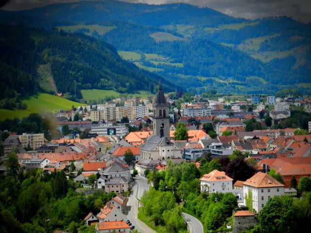
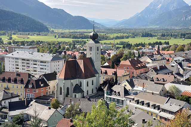
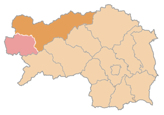
Murtal District (Bezirk Murtal)
.svg)
- district of Austria
 Hiking in Murtal District
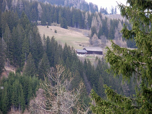
Murtal District, located in Styria, Austria, is a great destination for hiking enthusiasts. The region is characterized by its stunning landscapes, which include rolling hills, deep forests, and majestic mountain ranges, making it an ideal spot for nature lovers. Here are some highlights and recommendations for hiking in Murtal District:
Hiking Trails
-
Kreischberg: This area is popular for its well-maintained trails that cater to various skill levels. You can find lovely paths that lead to breathtaking panoramic views of the surrounding mountains.
-
Zirbitzkogel: A more challenging hike that rewards you with stunning vistas from the summit. The trail takes you through beautiful alpine meadows and diverse flora.
-
Mur Valley: This valley features a variety of trails along the Mur River, offering a more leisurely hike that allows you to enjoy the scenic beauty of the river and surrounding terrain.
-
Grüner See: A picturesque lake surrounded by mountains, it's a great location for a day hike. The area is known for its crystal-clear water and lush greenery, making it perfect for a relaxing picnic.
Tips for Hiking in Murtal District
-
Trail Markings: Most hiking trails in Murtal are well-marked, but it’s always a good idea to carry a local hiking map or download a hiking app to help navigate the paths.
-
Weather Conditions: The weather can vary significantly in the mountains, so check forecasts before you head out and be prepared for sudden changes.
-
Footwear and Gear: Proper hiking boots are essential due to uneven terrain. Additionally, consider taking trekking poles for support on steeper trails.
-
Local Wildlife: Be aware of local wildlife. It's advisable to stay on the marked trails and respect nature.
-
Guided Tours: If you're not familiar with the area, consider joining a guided hiking tour to enhance your experience and learn more about the local ecosystem and history.
Conclusion
Murtal District offers a diverse range of hiking opportunities suitable for all experience levels, from gentle walks to more demanding climbs. With its lush landscapes and serene environment, it's a fantastic place for outdoor adventures. Always remember to pack essentials and enjoy the breathtaking beauty that the region has to offer!
- Country:

- Capital: Judenburg
- Licence Plate Code: JU
- Coordinates: 47° 10' 21" N, 14° 39' 37" E


- GPS tracks (wikiloc): [Link]
- AboveSeaLevel: 714 м m
- Area: 1675.38 sq km
- Web site: http://www.bh-murtal.steiermark.at/
- Wikipedia en: wiki(en)
- Wikipedia: wiki(de)
- Wikidata storage: Wikidata: Q526517
- Wikipedia Commons Category: [Link]
- Freebase ID: [/m/0r4nqlv]
- GeoNames ID: Alt: [8604685]
- VIAF ID: Alt: [294235143]
- archINFORM location ID: [14692]
Includes regions:
Pöls-Oberkurzheim
- municipality in Austria
Hiking in Pöls-Oberkurzheim
Pöls-Oberkurzheim is a picturesque area located in Styria, Austria, known for its beautiful natural surroundings, making it an excellent destination for hiking enthusiasts. The region offers a variety of hiking trails that cater to different skill levels, from easy walks suitable for families to more challenging routes for experienced hikers....
- Country:
- Postal Code: 8753, 8754, 8761, 8762
- Local Dialing Code: 03579
- Licence Plate Code: MT
- Coordinates: 47° 13' 10" N, 14° 35' 2" E
- GPS tracks (wikiloc): [Link]
- AboveSeaLevel: 790 м m
- Area: 62.54 sq km
- Population: 2969
- Web site: [Link]
Pölstal
- municipality in Austria
Hiking in Pölstal
Pölstal is a beautiful valley located in the Austrian Alps, specifically in the state of Styria. It offers stunning landscapes, lush greenery, and a variety of hiking trails that cater to different skill levels. Here are some key points to consider when hiking in Pölstal:...
- Country:
- Postal Code: 8762, 8763, 8765
- Licence Plate Code: MT
- Coordinates: 47° 17' 0" N, 14° 29' 0" E
- GPS tracks (wikiloc): [Link]
- AboveSeaLevel: 915 м m
- Area: 270.22 sq km
- Population: 2670
- Web site: [Link]
Sankt Marein-Feistritz
- municipality in Austria
Hiking in Sankt Marein-Feistritz
Sankt Marein-Feistritz, located in the Styria region of Austria, offers a range of beautiful hiking opportunities in a picturesque setting characterized by lush forests, rolling hills, and scenic views of the surrounding countryside. Here are some key points to consider when planning your hiking adventure in this area:...
- Country:
- Postal Code: 8715, 8733
- Local Dialing Code: 03515
- Licence Plate Code: MT
- Coordinates: 47° 16' 16" N, 14° 51' 38" E
- GPS tracks (wikiloc): [Link]
- AboveSeaLevel: 698 м m
- Area: 70.61 sq km
- Population: 2010
- Web site: [Link]


Zeltweg
- municipality in Austria
Hiking in Zeltweg
Zeltweg, located in the Styria region of Austria, is surrounded by beautiful landscapes and offers a variety of outdoor activities, including hiking. Here are some key aspects to consider if you're planning a hiking trip in the Zeltweg area:...
- Country:
- Postal Code: 8740
- Local Dialing Code: 03577
- Licence Plate Code: MT
- Coordinates: 47° 11' 26" N, 14° 45' 4" E
- GPS tracks (wikiloc): [Link]
- AboveSeaLevel: 659 м m
- Area: 9 sq km
- Population: 7212
- Web site: [Link]

Judenburg
- municipality in Austria
Hiking in Judenburg
Judenburg, located in the Austrian region of Styria, is surrounded by beautiful landscapes, making it a great destination for hiking enthusiasts. The area offers a variety of trails that cater to different skill levels, from leisurely walks to more challenging hikes....
- Country:
- Postal Code: 8750
- Local Dialing Code: 03572
- Licence Plate Code: MT
- Coordinates: 47° 10' 21" N, 14° 39' 37" E
- GPS tracks (wikiloc): [Link]
- AboveSeaLevel: 737 м m
- Area: 64 sq km
- Population: 9960
- Web site: [Link]

Sankt Marein bei Knittelfeld
- former municipality in Austria
Hiking in Sankt Marein bei Knittelfeld
Sankt Marein bei Knittelfeld, located in Styria, Austria, offers a variety of beautiful hiking opportunities amid picturesque landscapes. The region is characterized by its lush forests, rolling hills, and stunning panoramic views, making it an ideal destination for both novice and experienced hikers....
- Country:
- Local Dialing Code: 03515
- Licence Plate Code: KF
- Coordinates: 47° 16' 16" N, 14° 51' 38" E
- GPS tracks (wikiloc): [Link]
- AboveSeaLevel: 698 м m
- Area: 60.64 sq km
- Population: 1245

Unzmarkt-Frauenburg
- municipality in Austria
Hiking in Unzmarkt-Frauenburg
Unzmarkt-Frauenburg, located in the heart of Styria in Austria, is a lovely destination for hikers and outdoor enthusiasts. The area offers a mix of beautiful landscapes, including rolling hills, dense forests, and stunning views of the surrounding mountains, making it a nice spot for various hiking experiences....
- Country:
- Postal Code: 8800
- Local Dialing Code: 03583
- Licence Plate Code: MT
- Coordinates: 47° 12' 1" N, 14° 26' 44" E
- GPS tracks (wikiloc): [Link]
- AboveSeaLevel: 745 м m
- Area: 36.55 sq km
- Population: 1346
- Web site: [Link]
Amering
- former municipality in Austria
Hiking in Amering
Amering is a region located in the Styrian Alps of Austria, known for its beautiful landscapes and outdoor recreational opportunities, including hiking. When hiking in Amering, you can enjoy stunning views of mountains, lush forests, and pristine alpine meadows....
- Country:
- Postal Code: 8742
- Local Dialing Code: 03578
- Licence Plate Code: JU
- Coordinates: 47° 3' 0" N, 14° 44' 0" E
- GPS tracks (wikiloc): [Link]
- AboveSeaLevel: 784 м m
- Area: 48 sq km
- Population: 1079

Knittelfeld
- municipality in Austria
Hiking in Knittelfeld
Knittelfeld, located in Austria's Styria region, offers a variety of hiking opportunities amidst beautiful landscapes, including rolling hills, forests, and mountainous terrain. Here are some highlights of hiking in and around Knittelfeld:...
- Country:
- Postal Code: 8720
- Local Dialing Code: 03512
- Licence Plate Code: MT
- Coordinates: 47° 12' 54" N, 14° 49' 46" E
- GPS tracks (wikiloc): [Link]
- AboveSeaLevel: 645 м m
- Area: 13.81 sq km
- Population: 12626
- Web site: [Link]

Sankt Lorenzen bei Knittelfeld
- former municipality in Austria
Hiking in Sankt Lorenzen bei Knittelfeld
Sankt Lorenzen bei Knittelfeld is a picturesque village located in the district of Knittelfeld in Styria, Austria. The area is known for its stunning natural landscapes, which provide excellent opportunities for hiking enthusiasts of all levels. Here are some key highlights regarding hiking in and around Sankt Lorenzen:...
- Country:
- Postal Code: 8715
- Local Dialing Code: 03515
- Licence Plate Code: KF
- Coordinates: 47° 15' 0" N, 14° 53' 0" E
- GPS tracks (wikiloc): [Link]
- AboveSeaLevel: 610 м m
- Area: 35.88 sq km
- Population: 803
Apfelberg
- former municipality in Austria
Hiking in Apfelberg
Apfelberg is a fantastic area for hiking enthusiasts, offering beautiful landscapes and varying terrain suitable for different skill levels. While it may not be as widely known as some other hiking destinations, it provides a unique experience for those looking to explore nature....
- Country:
- Postal Code: 8720
- Local Dialing Code: 03512
- Licence Plate Code: KF
- Coordinates: 47° 12' 10" N, 14° 50' 5" E
- GPS tracks (wikiloc): [Link]
- AboveSeaLevel: 625 м m
- Area: 9.29 sq km
- Population: 1145
Seckau
- municipality in Austria
Hiking in Seckau
Seckau, located in the Styria region of Austria, is known for its stunning natural landscapes and diverse hiking trails. Nestled within the Eastern Alps, it offers a variety of hiking experiences suitable for all skill levels, from leisurely walks to more challenging hikes....
- Country:
- Postal Code: 8732
- Local Dialing Code: 03514
- Licence Plate Code: MT
- Coordinates: 47° 16' 30" N, 14° 47' 6" E
- GPS tracks (wikiloc): [Link]
- AboveSeaLevel: 843 м m
- Area: 46.26 sq km
- Population: 1281
- Web site: [Link]

Hohentauern
- municipality in Austria
Hiking in Hohentauern
Hohentauern, located in the Austrian Alps, is a stunning area known for its beautiful alpine landscapes, diverse flora and fauna, and a variety of hiking trails suitable for all experience levels. Here are some key points to consider if you're planning to hike in Hohentauern:...
- Country:
- Postal Code: 8785
- Local Dialing Code: 03618
- Licence Plate Code: MT
- Coordinates: 47° 26' 3" N, 14° 29' 1" E
- GPS tracks (wikiloc): [Link]
- AboveSeaLevel: 1274 м m
- Area: 92.63 sq km
- Population: 408
- Web site: [Link]

Spielberg
- municipality in Austria
Hiking in Spielberg
Hiking in Spielberg, Styria, can be a delightful experience for outdoor enthusiasts. Located in the picturesque region of Styria, Spielberg offers a mix of beautiful landscapes, well-marked trails, and a variety of terrains suitable for hikers of all levels....
- Country:
- Licence Plate Code: MT
- Coordinates: 47° 13' 0" N, 14° 47' 0" E
- GPS tracks (wikiloc): [Link]
- AboveSeaLevel: 660 м m
- Area: 22.24 sq km
- Population: 5383
- Web site: [Link]
Bretstein
- former municipality in Austria
Hiking in Bretstein
Bretstein is a picturesque area located in Austria, known for its beautiful landscapes, scenic trails, and diverse hiking opportunities. Here’s an overview of what you can expect when hiking in the Bretstein region:...
- Country:
- Postal Code: 8763
- Local Dialing Code: 03573
- Licence Plate Code: JU
- Coordinates: 47° 20' 0" N, 14° 25' 0" E
- GPS tracks (wikiloc): [Link]
- AboveSeaLevel: 1036 м m
- Area: 91.31 sq km
- Population: 302
Eppenstein
- former municipality in Austria
Hiking in Eppenstein
Eppenstein is a charming location in Austria, known for its beautiful landscapes and various hiking opportunities. Nestled in the Styrian region, hikers can enjoy a mix of serene forest trails, mountainous terrain, and picturesque views. Here are some key points about hiking in Eppenstein:...
- Country:
- Local Dialing Code: 03577
- Licence Plate Code: JU
- Coordinates: 47° 7' 51" N, 14° 44' 22" E
- GPS tracks (wikiloc): [Link]
- AboveSeaLevel: 736 м m
- Area: 57.53 sq km
- Population: 1224

Fohnsdorf
- municipality in Austria
Hiking in Fohnsdorf
Fohnsdorf, located in Austria, is surrounded by picturesque landscapes and offers a variety of hiking opportunities for enthusiasts of all levels. Here are some highlights and tips for hiking in and around Fohnsdorf:...
- Country:
- Postal Code: 8753
- Local Dialing Code: 03573
- Licence Plate Code: JU
- Coordinates: 47° 12' 30" N, 14° 40' 46" E
- GPS tracks (wikiloc): [Link]
- AboveSeaLevel: 736 м m
- Area: 54.62 sq km
- Population: 7693
- Web site: [Link]
Oberzeiring
- former municipality in Austria
Hiking in Oberzeiring
Oberzeiring is a picturesque village located in Styria, Austria, nestled in the Eastern Alps. The region is known for its stunning natural landscapes, diverse flora and fauna, and a network of well-marked hiking trails that cater to various skill levels. Here are some highlights regarding hiking in and around Oberzeiring:...
- Country:
- Local Dialing Code: 03571
- Licence Plate Code: JU
- Coordinates: 47° 15' 0" N, 14° 29' 0" E
- GPS tracks (wikiloc): [Link]
- AboveSeaLevel: 932 м m
- Area: 38.23 sq km
Reifling
- former municipality in Austria
Hiking in Reifling
Reifling, which is located in Austria, offers a variety of hiking opportunities that cater to different skill levels and preferences. The region is known for its stunning natural landscapes, including lush forests, rolling hills, and beautiful alpine scenery....
- Country:
- Postal Code: 8750
- Local Dialing Code: 03572
- Licence Plate Code: JU
- Coordinates: 47° 9' 0" N, 14° 41' 0" E
- GPS tracks (wikiloc): [Link]
- AboveSeaLevel: 815 м m
- Area: 16.22 sq km
- Population: 376
Sankt Anna am Lavantegg
- former municipality in Austria
Hiking in Sankt Anna am Lavantegg
Sankt Anna am Lavantegg is a beautiful hiking destination located in the eastern part of Austria, in the state of Styria. It offers a scenic landscape characterized by lush forests, rolling hills, and breathtaking views of the surrounding mountains. Here are some highlights for hiking in this area:...
- Country:
- Postal Code: 8742
- Local Dialing Code: 03578
- Licence Plate Code: MT
- Coordinates: 47° 2' 19" N, 14° 41' 19" E
- GPS tracks (wikiloc): [Link]
- AboveSeaLevel: 1180 м m
- Area: 47.16 sq km
- Population: 388
Reisstraße
- former municipality in Austria
Hiking in Reisstraße
Reisstraße, known for its scenic landscapes, is a popular spot for hikers who want to experience nature. While I don't have specific information on a hiking trail named Reisstraße, it may refer to a location in a particular region known for its outdoor activities....
- Country:
- Postal Code: 8741
- Local Dialing Code: 03516
- Licence Plate Code: JU
- Coordinates: 47° 8' 5" N, 14° 49' 47" E
- GPS tracks (wikiloc): [Link]
- AboveSeaLevel: 842 м m
- Area: 62.28 sq km
- Population: 166
Pusterwald
- municipality in Austria
Hiking in Pusterwald
Pusterwald is a lovely destination for hiking enthusiasts, located in the Steiermark region of Austria. It is known for its beautiful landscapes, pristine nature, and variety of trails suitable for different skill levels. Here are some key points to consider if you’re planning a hiking trip to Pusterwald:...
- Country:
- Postal Code: 8764
- Local Dialing Code: 03574
- Licence Plate Code: MT
- Coordinates: 47° 18' 31" N, 14° 22' 30" E
- GPS tracks (wikiloc): [Link]
- AboveSeaLevel: 1072 м m
- Area: 105.21 sq km
- Population: 450
- Web site: [Link]

Sankt Margarethen bei Knittelfeld
- municipality in Austria
Hiking in Sankt Margarethen bei Knittelfeld
Sankt Margarethen bei Knittelfeld is a picturesque village located in the Austrian state of Styria, surrounded by beautiful landscapes and mountainous terrain ideal for hiking enthusiasts. The area offers a variety of hiking trails catering to different skill levels, making it accessible for both beginners and experienced hikers....
- Country:
- Postal Code: 8720
- Local Dialing Code: 03512
- Licence Plate Code: MT
- Coordinates: 47° 13' 36" N, 14° 51' 32" E
- GPS tracks (wikiloc): [Link]
- AboveSeaLevel: 623 м m
- Area: 148.22 sq km
- Population: 2750
- Web site: [Link]
Weißkirchen in Steiermark
- municipality in Austria
Hiking in Weißkirchen in Steiermark
Weißkirchen in Steiermark is a beautiful village located in the heart of Austria's Styria region, surrounded by lush landscapes and rolling hills. The area offers a variety of hiking opportunities, catering to different skill levels and preferences. Here are some highlights if you're considering hiking in Weißkirchen:...
- Country:
- Postal Code: 8741
- Local Dialing Code: 03577
- Licence Plate Code: MT
- Coordinates: 47° 9' 14" N, 14° 44' 19" E
- GPS tracks (wikiloc): [Link]
- AboveSeaLevel: 689 м m
- Area: 1.27 sq km
- Population: 4853
- Web site: [Link]
Sankt Wolfgang-Kienberg
- former municipality in Austria
Hiking in Sankt Wolfgang-Kienberg
Sankt Wolfgang-Kienberg, located in Austria, is a beautiful area known for its scenic landscapes and outdoor activities, including hiking. The region is characterized by its stunning views of the surrounding mountains, forests, and lakes, making it a popular destination for both casual hikers and experienced trekkers alike....
- Country:
- Postal Code: 8742
- Local Dialing Code: 03578
- Licence Plate Code: MT
- Coordinates: 47° 6' 1" N, 14° 38' 53" E
- GPS tracks (wikiloc): [Link]
- AboveSeaLevel: 1260 м m
- Area: 20.39 sq km
- Population: 372
Sankt Johann am Tauern
- former municipality in Austria
Hiking in Sankt Johann am Tauern
Sankt Johann am Tauern is a charming village located in Austria, nestled in the mountainous region of Styria. This area is known for its picturesque landscapes, making it an excellent destination for hiking enthusiasts. Here are some key points to consider for hiking in Sankt Johann am Tauern:...
- Country:
- Postal Code: 8765
- Local Dialing Code: 03575
- Licence Plate Code: JU
- Coordinates: 47° 21' 0" N, 14° 28' 0" E
- GPS tracks (wikiloc): [Link]
- AboveSeaLevel: 1056 м m
- Area: 84.77 sq km
- Population: 475

Gaal
- municipality in Austria
Hiking in Gaal
Gaal, located in Styria, Austria, is a delightful destination for hiking enthusiasts. The region is characterized by its stunning natural landscapes, rolling hills, dense forests, and panoramic views. Here are some highlights and considerations for hiking in this area:...
- Country:
- Postal Code: 8731
- Local Dialing Code: 03513
- Licence Plate Code: KF
- Coordinates: 47° 16' 23" N, 14° 40' 12" E
- GPS tracks (wikiloc): [Link]
- AboveSeaLevel: 900 м m
- Area: 197.37 sq km
- Population: 1376
- Web site: [Link]

Sankt Peter ob Judenburg
- municipality in Austria
Hiking in Sankt Peter ob Judenburg
Sankt Peter ob Judenburg, located in the Styria region of Austria, is a beautiful area for hiking enthusiasts. Surrounded by the scenic landscape of the Judenburg highlands and the nearby mountains, it offers a variety of trails suitable for different skill levels....
- Country:
- Postal Code: 8755
- Local Dialing Code: 03572; 03579
- Licence Plate Code: MT
- Coordinates: 47° 11' 0" N, 14° 35' 0" E
- GPS tracks (wikiloc): [Link]
- AboveSeaLevel: 750 м m
- Area: 50.36 sq km
- Population: 1108
- Web site: [Link]
Flatschach
- former municipality in Austria
Hiking in Flatschach
Flatschach is a picturesque area located in Austria, known for its stunning natural landscapes and access to various hiking trails. Here’s what you need to know about hiking in Flatschach:...
- Country:
- Postal Code: 8720
- Local Dialing Code: 03577
- Licence Plate Code: KF
- Coordinates: 47° 13' 0" N, 14° 45' 17" E
- GPS tracks (wikiloc): [Link]
- AboveSeaLevel: 682 м m
- Area: 7.43 sq km
- Population: 192
Großlobming
- municipality in Austria
Hiking in Großlobming
Lobmingtal, a picturesque valley located in Austria, offers a variety of hiking opportunities that cater to different skill levels and preferences. Nestled in the Styria region, it boasts stunning landscapes, lush greenery, and mountainous terrain, making it an excellent destination for outdoor enthusiasts....
- Country:
- Postal Code: 8734
- Local Dialing Code: 03512
- Licence Plate Code: MT
- Coordinates: 47° 11' 4" N, 14° 48' 32" E
- GPS tracks (wikiloc): [Link]
- AboveSeaLevel: 614 м m
- Area: 54.38 sq km
- Population: 1852
- Web site: [Link]
Sankt Oswald-Möderbrugg
- former municipality in Austria
Hiking in Sankt Oswald-Möderbrugg
Sankt Oswald-Möderbrugg is a picturesque area in Austria, located in the state of Styria. It offers a variety of hiking trails that cater to different skill levels and interests, making it an excellent destination for both novice and experienced hikers....
- Country:
- Local Dialing Code: 03571
- Licence Plate Code: JU
- Coordinates: 47° 17' 0" N, 14° 29' 0" E
- GPS tracks (wikiloc): [Link]
- AboveSeaLevel: 915 м m
- Area: 56.26 sq km
- Population: 1157
Pöls
- former municipality in Austria
Hiking in Pöls
Pöls, located in Austria, is a bit lesser-known but offers some beautiful hiking opportunities, especially for those who enjoy scenic landscapes and a more tranquil environment. The region is surrounded by the stunning backdrop of the Styrian Alps, providing plenty of trails that cater to different skill levels....
- Country:
- Local Dialing Code: 03579
- Licence Plate Code: JU
- Coordinates: 47° 13' 10" N, 14° 35' 2" E
- GPS tracks (wikiloc): [Link]
- AboveSeaLevel: 790 м m
- Area: 33.52 sq km
- Population: 2367


Feistritz bei Knittelfeld
- former municipality in Austria
Hiking in Feistritz bei Knittelfeld
Feistritz bei Knittelfeld, located in Styria, Austria, is a beautiful area for hiking, surrounded by lush landscapes, rolling hills, and scenic views. The region offers a variety of hiking trails suitable for different skill levels, from leisurely walks to more challenging hikes....
- Country:
- Postal Code: 8715
- Local Dialing Code: 03515
- Licence Plate Code: KF
- Coordinates: 47° 16' 5" N, 14° 53' 33" E
- GPS tracks (wikiloc): [Link]
- AboveSeaLevel: 647 м m
- Area: 9.93 sq km
- Population: 784
Kleinlobming
- former municipality in Austria
Hiking in Kleinlobming
Kleinlobming is a charming destination located in Austria, known for its stunning landscapes and opportunities for outdoor activities, including hiking. The region is characterized by its picturesque hills, dense forests, and beautiful meadows, making it an ideal spot for both novice and experienced hikers....
- Country:
- Local Dialing Code: 03516
- Licence Plate Code: KF
- Coordinates: 47° 9' 0" N, 14° 50' 50" E
- GPS tracks (wikiloc): [Link]
- AboveSeaLevel: 759 м m
- Area: 47.12 sq km
- Population: 616
Obdach
- municipality in Austria
Hiking in Obdach
Obdach, a picturesque village in Austria, is situated in the scenic region of Styria. This area is known for its stunning landscapes, rolling hills, and beautiful forests, making it an excellent destination for hiking enthusiasts....
- Country:
- Postal Code: 8742
- Local Dialing Code: 03578
- Licence Plate Code: JU
- Coordinates: 47° 4' 0" N, 14° 42' 0" E
- GPS tracks (wikiloc): [Link]
- AboveSeaLevel: 877 м m
- Area: 42.89 sq km
- Population: 3810
- Web site: [Link]
Oberweg
- former municipality in Austria
Hiking in Oberweg
Oberweg, located in the heart of the Swiss Alps, is an impressive destination for hiking enthusiasts. It's renowned for its breathtaking alpine scenery, well-maintained trails, and a variety of routes catering to all skill levels. Here are some key points about hiking in Oberweg:...
- Country:
- Postal Code: 8750
- Local Dialing Code: 03572
- Licence Plate Code: JU
- Coordinates: 47° 9' 21" N, 14° 38' 32" E
- GPS tracks (wikiloc): [Link]
- AboveSeaLevel: 760 м m
- Area: 34.25 sq km
- Population: 578
Rachau
- former municipality in Austria
Hiking in Rachau
Rachau is a lesser-known hiking destination located in Austria, specifically in Styria, surrounded by beautiful landscapes and natural scenery. Though it might not be as popular as some major hiking regions, it offers a range of hiking opportunities for both beginners and experienced trekkers....
- Country:
- Postal Code: 8720
- Local Dialing Code: 03512
- Licence Plate Code: KF
- Coordinates: 47° 13' 2" N, 14° 54' 54" E
- GPS tracks (wikiloc): [Link]
- AboveSeaLevel: 760 м m
- Area: 104.93 sq km
- Population: 613
Sankt Georgen ob Judenburg
- municipality in Austria
Hiking in Sankt Georgen ob Judenburg
Sankt Georgen ob Judenburg is a picturesque village located in the Styria region of Austria. It offers a variety of hiking opportunities amid stunning natural landscapes, making it a great destination for outdoor enthusiasts. Here are some highlights and tips for hiking in this area:...
- Country:
- Postal Code: 8756
- Local Dialing Code: 03583
- Licence Plate Code: MT
- Coordinates: 47° 12' 23" N, 14° 29' 53" E
- GPS tracks (wikiloc): [Link]
- AboveSeaLevel: 734 м m
- Area: 44.32 sq km
- Population: 850
- Web site: [Link]
Oberkurzheim
- former municipality in Austria
Hiking in Oberkurzheim
Oberkurzheim is a picturesque area that offers a range of hiking opportunities, typically characterized by beautiful landscapes, lush greenery, and well-marked trails. Though specific details about Oberkurzheim may vary, here are some general aspects to consider when hiking in the region:...
- Country:
- Postal Code: 8761
- Local Dialing Code: 03579
- Licence Plate Code: MT
- Coordinates: 47° 13' 48" N, 14° 34' 55" E
- GPS tracks (wikiloc): [Link]
- AboveSeaLevel: 861 м m
- Area: 29.15 sq km
- Population: 693

Kobenz
- municipality in Austria
Hiking in Kobenz
Kobenz is a charming area located in Austria, known for its breathtaking landscapes and excellent hiking opportunities. Situated near the scenic Enns Valley, Kobenz offers access to beautiful mountain trails, lush forests, and stunning views of the surrounding Alps....
- Country:
- Postal Code: 8723
- Licence Plate Code: MT
- Coordinates: 47° 15' 0" N, 14° 51' 0" E
- GPS tracks (wikiloc): [Link]
- AboveSeaLevel: 627 м m
- Area: 17.64 sq km
- Population: 1864
- Web site: [Link]
Maria Buch-Feistritz
- former municipality in Austria
Hiking in Maria Buch-Feistritz
Maria Buch-Feistritz is a small municipality located in the beautiful Styria region of Austria, nestled amidst picturesque landscapes that make it an appealing destination for hiking enthusiasts. The area is characterized by rolling hills, lush forests, and charming villages, offering a variety of trails suitable for different skill levels....
- Country:
- Local Dialing Code: 03577
- Licence Plate Code: JU
- Coordinates: 47° 9' 15" N, 14° 42' 26" E
- GPS tracks (wikiloc): [Link]
- AboveSeaLevel: 660 м m
- Area: 28.47 sq km
- Population: 2241
Shares border with regions:
Liezen District
- district of Austria
Hiking in Liezen District
The Liezen District, located in the Styria region of Austria, is a fantastic destination for hiking enthusiasts. It boasts stunning landscapes characterized by rugged mountains, lush forests, and scenic valleys. Here are some highlights and tips for hiking in the Liezen District:...
- Country:
- Capital: Liezen
- Licence Plate Code: LI
- Coordinates: 47° 31' 37" N, 14° 6' 58" E
- GPS tracks (wikiloc): [Link]
- AboveSeaLevel: 945 м m
- Area: 3317 sq km
- Population: 79862
- Web site: [Link]


Murau District
- district of Austria
Hiking in Murau District
Murau District, located in Styria, Austria, is a fantastic destination for hiking enthusiasts. Characterized by its stunning natural landscapes, lush forests, and picturesque alpine scenery, the area offers a variety of trails suitable for different skill levels, from gentle walks to challenging hikes....
- Country:
- Licence Plate Code: MU
- Coordinates: 47° 7' 1" N, 14° 16' 59" E
- GPS tracks (wikiloc): [Link]
- AboveSeaLevel: 1510 м m
- Area: 1384 sq km
- Population: 28388


Graz-Umgebung District
- district in Austria
Hiking in Graz-Umgebung District
Graz-Umgebung District, located around the city of Graz in Austria, offers a wide range of hiking opportunities, featuring scenic landscapes, lush forests, and picturesque hilltops. Here are some highlights and recommendations for hiking in this area:...
- Country:
- Capital: Graz
- Licence Plate Code: GU
- Coordinates: 47° 3' 43" N, 15° 24' 54" E
- GPS tracks (wikiloc): [Link]
- AboveSeaLevel: 522 м m
- Area: 1100.7 sq km
- Population: 148830
- Web site: [Link]