Nantes-en-Ratier (Nantes-en-Ratier)
- commune in Isère, France
Nantes-en-Rattier is a charming village located in the Isère department of the Auvergne-Rhône-Alpes region in southeastern France. It offers a serene environment ideal for hiking enthusiasts looking to explore the natural beauty of the French Alps.
Hiking Trails:
-
Local Trails: Nantes-en-Rattier has several marked hiking trails that cater to different skill levels, including both easy walks perfect for families and more challenging hikes for seasoned trekkers. The trails often showcase stunning views of the surrounding mountains, valleys, and the unique flora and fauna of the region.
-
Verney Dam Loop: One popular trail takes you around the Verney Dam, where you can enjoy picturesque views of the water and mountains. The loop provides a moderate hiking experience and includes opportunities for picnicking.
-
Mountain Trails: For those looking for more adventure, trails leading up to the surrounding peaks can be found. These hikes often offer rewarding panoramic views, especially at sunrise or sunset.
Best Time to Hike:
- Spring and Fall: Typically, late spring (May to June) and early fall (September to October) are the best times for hiking in this region, as the weather is generally pleasant, and the trails are less crowded.
- Summer: Summer months can also be enjoyable, but be prepared for warmer temperatures, especially at lower elevations.
Preparation:
- Maps and Guides: It is advised to carry a good map and possibly download hiking apps that work offline, as mobile reception may vary in remote areas.
- Gear: Sturdy hiking boots, plenty of water, snacks, sun protection, and weather-appropriate clothing are essential for a comfortable hiking experience.
Nearby Attractions:
- Natural Parks: Consider exploring nearby natural parks, such as the Ecrins National Park, which offers additional hiking opportunities and stunning landscapes.
- Cultural Sites: Nantes-en-Rattier is also near various cultural and historical sites that may enhance your trip by providing insight into the region's heritage.
Whether you're looking for peaceful walks or challenging hikes, Nantes-en-Rattier offers diverse terrain and beautiful scenery. Always remember to follow local guidelines, respect the environment, and stay safe on the trails!
- Country:

- Postal Code: 38350
- Coordinates: 44° 56' 6" N, 5° 49' 36" E


- GPS tracks (wikiloc): [Link]
- AboveSeaLevel: 930 м m
- Area: 12.13 sq km
- Population: 465
- Wikipedia en: wiki(en)
- Wikipedia: wiki(fr)
- Wikidata storage: Wikidata: Q1154638
- Wikipedia Commons Category: [Link]
- Freebase ID: [/m/03g_0z5]
- GeoNames ID: Alt: [6616664]
- SIREN number: [213802739]
- BnF ID: [15258085c]
- INSEE municipality code: 38273
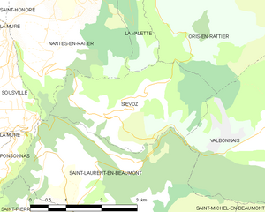
Shares border with regions:


La Valette
- commune in Isère, France
La Valette, located in the stunning landscape of Malta, offers a unique hiking experience characterized by its rich history and scenic views. Here are some points to consider when planning a hike in La Valette:...
- Country:

- Postal Code: 38350
- Coordinates: 44° 56' 31" N, 5° 51' 23" E


- GPS tracks (wikiloc): [Link]
- AboveSeaLevel: 850 м m
- Area: 7.87 sq km
- Population: 73


Siévoz
- commune in Isère, France
Siévoz is a beautiful area in the French Alps, known for its scenic landscapes and hiking opportunities. If you're planning a hiking trip there, here are some key points to consider:...
- Country:

- Postal Code: 38350
- Coordinates: 44° 54' 12" N, 5° 50' 15" E


- GPS tracks (wikiloc): [Link]
- Area: 7.37 sq km
- Population: 136


Saint-Honoré
- commune in Isère, France
Saint-Honoré is a charming village located in the Isère department of the Auvergne-Rhône-Alpes region in southeastern France. It is surrounded by the beautiful Vercors and Chartreuse mountain ranges, making it an excellent base for hiking enthusiasts. Here are some highlights and tips for hiking in and around Saint-Honoré:...
- Country:

- Postal Code: 38350
- Coordinates: 44° 57' 16" N, 5° 48' 24" E


- GPS tracks (wikiloc): [Link]
- Area: 14.58 sq km
- Population: 806

Saint-Laurent-en-Beaumont
- commune in Isère, France
 Hiking in Saint-Laurent-en-Beaumont
Saint-Laurent-en-Beaumont is a charming commune located in the Isère department in the Auvergne-Rhône-Alpes region of southeastern France. It offers excellent opportunities for hiking and outdoor activities, set amidst stunning natural scenery, including mountains and forests....
- Country:

- Postal Code: 38350
- Coordinates: 44° 52' 45" N, 5° 51' 1" E


- GPS tracks (wikiloc): [Link]
- Area: 13.15 sq km
- Population: 462
- Web site: [Link]


Sousville
- commune in Isère, France
Sousville is situated in the picturesque region of the French Alps, providing a stunning backdrop for hiking enthusiasts. The area is known for its diverse landscapes, including rolling hills, rocky terrain, and lush forests, making it an excellent destination for hikers of all levels....
- Country:

- Postal Code: 38350
- Coordinates: 44° 54' 48" N, 5° 48' 26" E


- GPS tracks (wikiloc): [Link]
- AboveSeaLevel: 760 м m
- Area: 2.93 sq km
- Population: 141
