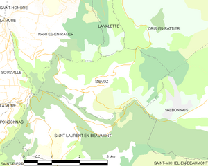
Siévoz (Siévoz)
- commune in Isère, France
Siévoz is a beautiful area in the French Alps, known for its scenic landscapes and hiking opportunities. If you're planning a hiking trip there, here are some key points to consider:
Trails and Difficulty
- Variety of Trails: Siévoz offers a range of hiking trails suitable for different skill levels, from easy, family-friendly walks to challenging mountain hikes.
- Difficulty Levels: You can find trails that cater to beginners as well as more experienced hikers. Be sure to check trail maps and descriptions to match your skill level with the appropriate trail.
Highlights
- Nature: The region is renowned for its stunning alpine scenery, including breathtaking mountain vistas, lush forests, and clear lakes.
- Wildlife: Keep an eye out for local wildlife, including various species of birds and possibly deer or chamois in the higher altitudes.
Best Time to Hike
- Season: The best months for hiking in Siévoz are typically from late spring to early autumn (around May to September) when the weather is mild and the trails are accessible.
- Weather Considerations: Always check the weather forecast before heading out, as mountain weather can change rapidly.
Preparation
- Gear: Wear appropriate hiking gear, including sturdy hiking boots, breathable clothing, and a good backpack. Don’t forget essentials like water, snacks, a map, and sunscreen.
- Navigation: While many trails are well-marked, it’s always good to carry a map or a GPS device.
Local Regulations
- Respect Nature: Follow Leave No Trace principles to preserve the natural beauty of the area. Stay on marked trails, and be cautious with fire and litter.
In summary, hiking in Siévoz can be a rewarding experience, with its stunning landscapes and rich wildlife. Just remember to prepare adequately and choose trails that match your experience level. Enjoy your hike!
- Country:

- Postal Code: 38350
- Coordinates: 44° 54' 12" N, 5° 50' 15" E


- GPS tracks (wikiloc): [Link]
- Area: 7.37 sq km
- Population: 136
- Wikipedia en: wiki(en)
- Wikipedia: wiki(fr)
- Wikidata storage: Wikidata: Q1067481
- Wikipedia Commons Category: [Link]
- Freebase ID: [/m/03nvkt1]
- GeoNames ID: Alt: [6433420]
- SIREN number: [213804891]
- INSEE municipality code: 38489
Shares border with regions:


La Valette
- commune in Isère, France
La Valette, located in the stunning landscape of Malta, offers a unique hiking experience characterized by its rich history and scenic views. Here are some points to consider when planning a hike in La Valette:...
- Country:

- Postal Code: 38350
- Coordinates: 44° 56' 31" N, 5° 51' 23" E


- GPS tracks (wikiloc): [Link]
- AboveSeaLevel: 850 м m
- Area: 7.87 sq km
- Population: 73


Oris-en-Rattier
- commune in Isère, France
Oris-en-Rattier is a charming little village in the Isère department in the Auvergne-Rhône-Alpes region of France. Nestled within the stunning landscapes of the French Alps, it offers a range of hiking opportunities for enthusiasts of all levels....
- Country:

- Postal Code: 38350
- Coordinates: 44° 55' 16" N, 5° 52' 12" E


- GPS tracks (wikiloc): [Link]
- Area: 18.83 sq km
- Population: 111

Saint-Laurent-en-Beaumont
- commune in Isère, France
 Hiking in Saint-Laurent-en-Beaumont
Saint-Laurent-en-Beaumont is a charming commune located in the Isère department in the Auvergne-Rhône-Alpes region of southeastern France. It offers excellent opportunities for hiking and outdoor activities, set amidst stunning natural scenery, including mountains and forests....
- Country:

- Postal Code: 38350
- Coordinates: 44° 52' 45" N, 5° 51' 1" E


- GPS tracks (wikiloc): [Link]
- Area: 13.15 sq km
- Population: 462
- Web site: [Link]


Nantes-en-Ratier
- commune in Isère, France
Nantes-en-Rattier is a charming village located in the Isère department of the Auvergne-Rhône-Alpes region in southeastern France. It offers a serene environment ideal for hiking enthusiasts looking to explore the natural beauty of the French Alps....
- Country:

- Postal Code: 38350
- Coordinates: 44° 56' 6" N, 5° 49' 36" E


- GPS tracks (wikiloc): [Link]
- AboveSeaLevel: 930 м m
- Area: 12.13 sq km
- Population: 465


Valbonnais
- commune in Isère, France
Valbonnais is a beautiful area located in the French Alps, specifically in the Isère department. It’s known for its stunning natural landscapes, diversity of hiking trails, and rich cultural heritage. Here’s what you need to know about hiking in Valbonnais:...
- Country:

- Postal Code: 38740
- Coordinates: 44° 54' 0" N, 5° 54' 15" E


- GPS tracks (wikiloc): [Link]
- Area: 23.95 sq km
- Population: 499
- Web site: [Link]
