Saint-Laurent-en-Beaumont (Saint-Laurent-en-Beaumont)

- commune in Isère, France
 Hiking in Saint-Laurent-en-Beaumont
Saint-Laurent-en-Beaumont is a charming commune located in the Isère department in the Auvergne-Rhône-Alpes region of southeastern France. It offers excellent opportunities for hiking and outdoor activities, set amidst stunning natural scenery, including mountains and forests.
Hiking Opportunities:
-
Scenic Trails: The area features a network of well-marked hiking trails catering to various skill levels. Whether you are looking for a leisurely walk or a more challenging hike, you'll find routes that suit your preferences.
-
Breathtaking Views: Hikers can enjoy panoramic views of the surrounding mountains and valleys. The trails often lead through picturesque landscapes that include lush forests, clear streams, and alpine meadows.
-
Nature and Wildlife: While hiking in Saint-Laurent-en-Beaumont, keep an eye out for local flora and fauna. The region is home to diverse wildlife, and the varied ecosystems can be fascinating to explore.
-
Local Attractions: In addition to natural beauty, the area may feature local historical sites or traditional villages that you can visit along the way. These can provide insights into the region's culture and history.
Preparing for Your Hike:
-
Trail Maps: It's advisable to have a good map of the area, which can often be obtained from local tourist offices or online resources. Many trails are marked, but having a map is helpful for navigation.
-
Weather Conditions: Before heading out, check the weather conditions, as they can change rapidly in mountainous areas. Dress in layers and be prepared for varying temperatures.
-
Safety Gear: Make sure to wear sturdy hiking boots, carry enough water, and bring snacks. A first-aid kit is also a good idea, as well as a fully charged cell phone for emergencies.
-
Respect Nature: Follow the Leave No Trace principles to minimize your impact on the environment. Stick to marked paths, and be mindful of wildlife.
Local Hiking Groups:
If you're new to hiking or want to meet fellow outdoor enthusiasts, consider joining a local hiking group or guided tour. These can provide a more enriching experience and ensure you explore the area safely.
Conclusion:
Hiking in Saint-Laurent-en-Beaumont offers a wonderful way to experience the natural beauty and tranquility of the French Alps. Whether you're a novice hiker or a seasoned pro, the trails here promise an enjoyable adventure in nature.
- Country:

- Postal Code: 38350
- Coordinates: 44° 52' 45" N, 5° 51' 1" E


- GPS tracks (wikiloc): [Link]
- Area: 13.15 sq km
- Population: 462
- Web site: http://www.mairie-saint-laurent-en-beaumont.fr
- Wikipedia en: wiki(en)
- Wikipedia: wiki(fr)
- Wikidata storage: Wikidata: Q1150622
- Wikipedia Commons Category: [Link]
- Freebase ID: [/m/03nvh0c]
- GeoNames ID: Alt: [6433361]
- SIREN number: [213804131]
- BnF ID: [152582221]
- INSEE municipality code: 38413
Shares border with regions:

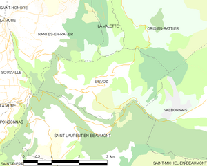
Siévoz
- commune in Isère, France
Hiking in Siévoz
Siévoz is a beautiful area in the French Alps, known for its scenic landscapes and hiking opportunities. If you're planning a hiking trip there, here are some key points to consider:...
- Country:
- Postal Code: 38350
- Coordinates: 44° 54' 12" N, 5° 50' 15" E
- GPS tracks (wikiloc): [Link]
- Area: 7.37 sq km
- Population: 136


Saint-Pierre-de-Méaroz
- commune in Isère, France
Hiking in Saint-Pierre-de-Méaroz
Saint-Pierre-de-Méaroz is a small village located in the Auvergne-Rhône-Alpes region of France, often considered part of the scenic landscapes of the French Alps. The area offers a variety of hiking opportunities that cater to different skill levels and preferences....
- Country:
- Postal Code: 38350
- Coordinates: 44° 52' 30" N, 5° 49' 25" E
- GPS tracks (wikiloc): [Link]
- Area: 4.64 sq km
- Population: 132


Nantes-en-Ratier
- commune in Isère, France
Hiking in Nantes-en-Ratier
Nantes-en-Rattier is a charming village located in the Isère department of the Auvergne-Rhône-Alpes region in southeastern France. It offers a serene environment ideal for hiking enthusiasts looking to explore the natural beauty of the French Alps....
- Country:
- Postal Code: 38350
- Coordinates: 44° 56' 6" N, 5° 49' 36" E
- GPS tracks (wikiloc): [Link]
- AboveSeaLevel: 930 м m
- Area: 12.13 sq km
- Population: 465


Saint-Michel-en-Beaumont
- commune in Isère, France
Hiking in Saint-Michel-en-Beaumont
Saint-Michel-en-Beaumont is a picturesque village located in the Auvergne-Rhône-Alpes region of southeastern France. This area is known for its stunning natural landscapes, rolling hills, and diverse outdoor activities, making it a great destination for hiking enthusiasts....
- Country:
- Postal Code: 38350
- Coordinates: 44° 52' 6" N, 5° 53' 59" E
- GPS tracks (wikiloc): [Link]
- Area: 8.04 sq km
- Population: 31
- Web site: [Link]


Valbonnais
- commune in Isère, France
Hiking in Valbonnais
Valbonnais is a beautiful area located in the French Alps, specifically in the Isère department. It’s known for its stunning natural landscapes, diversity of hiking trails, and rich cultural heritage. Here’s what you need to know about hiking in Valbonnais:...
- Country:
- Postal Code: 38740
- Coordinates: 44° 54' 0" N, 5° 54' 15" E
- GPS tracks (wikiloc): [Link]
- Area: 23.95 sq km
- Population: 499
- Web site: [Link]

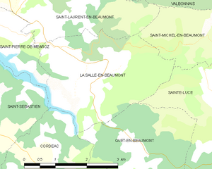
La Salle-en-Beaumont
- commune in Isère, France
Hiking in La Salle-en-Beaumont
La Salle-en-Beaumont is a picturesque commune located in the Isère department of the Auvergne-Rhône-Alpes region in southeastern France. It is surrounded by the stunning natural landscapes of the French Alps, making it an excellent destination for hiking enthusiasts....
- Country:
- Postal Code: 38350
- Coordinates: 44° 51' 43" N, 5° 51' 50" E
- GPS tracks (wikiloc): [Link]
- Area: 9.26 sq km
- Population: 323
- Web site: [Link]


Sousville
- commune in Isère, France
Hiking in Sousville
Sousville is situated in the picturesque region of the French Alps, providing a stunning backdrop for hiking enthusiasts. The area is known for its diverse landscapes, including rolling hills, rocky terrain, and lush forests, making it an excellent destination for hikers of all levels....
- Country:
- Postal Code: 38350
- Coordinates: 44° 54' 48" N, 5° 48' 26" E
- GPS tracks (wikiloc): [Link]
- AboveSeaLevel: 760 м m
- Area: 2.93 sq km
- Population: 141


Ponsonnas
- commune in Isère, France
Hiking in Ponsonnas
Ponsonnas is a small commune located in the Isère department in the Auvergne-Rhône-Alpes region of France. It presents a charming destination for those who love hiking and exploring nature....
- Country:
- Postal Code: 38350
- Coordinates: 44° 53' 21" N, 5° 47' 48" E
- GPS tracks (wikiloc): [Link]
- Area: 2.9 sq km
- Population: 281